 view gallery view gallery S89.3 km S89.3 km
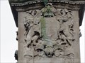
|   Queen Victoria's Coat of Arms - Leeds, UK Queen Victoria's Coat of Arms - Leeds, UK
in Coats of Arms These coat of arms are on the front of a statue of Queen Victoria in Woodhouse Moor Park. posted by:  dtrebilc dtrebilc location: Yorkshire, United Kingdom date approved: 03/19/2017 last visited: never |
 view gallery view gallery SW104.4 km SW104.4 km
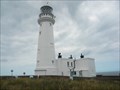
|  Flamborough Light House Flamborough Light House
in Coastal Lighthouses The Lighthouse at Flamborough, Yorkshire posted by:  Smithbats Smithbats location: Yorkshire, United Kingdom date approved: 01/20/2011 last visited: 09/27/2015 |
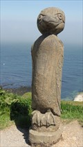 view gallery view gallerySW104.4 km |  Gannet – Flamborough Head, UK Gannet – Flamborough Head, UK
in Figurative Public Sculpture This wooden sculpture of a gannet stands on cliffs near to the nesting sites of many real life gannets. posted by: dtrebilc location: Yorkshire, United Kingdom date approved: 06/22/2012 last visited: 08/23/2012 |
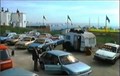 view gallery view gallerySW104.6 km |  Flamborough Head, Yorks, UK – Hunting Venus (1999) Flamborough Head, Yorks, UK – Hunting Venus (1999)
in Movie Locations At the start of the film Simon buys a car from a car dealer in the car park at Flamborough Head. posted by: bill&ben location: Yorkshire, United Kingdom date approved: 06/14/2014 last visited: never |
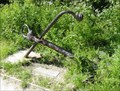 view gallery view gallerySW107 km |  South Landing Nature Reserve Anchor – Flamborough Head, UK South Landing Nature Reserve Anchor – Flamborough Head, UK
in Anchors This rusty anchor stands at the entrance to the South Landing nature reserve on the headland at Flamborough. posted by: dtrebilc location: Yorkshire, United Kingdom date approved: 11/18/2012 last visited: never |
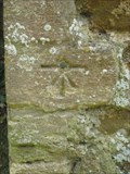 view gallery view gallerySW113.3 km |  Cut Bench mark with rivet - All Saints Church, North Runcton, Norfolk Cut Bench mark with rivet - All Saints Church, North Runcton, Norfolk
in U.K. and Ireland Trigpoints A cut benchmark with rivet on this Grade I listed Georgian Church in North Runcton. posted by: Norfolk12 location: Eastern England, United Kingdom date approved: 08/23/2010 last visited: never |
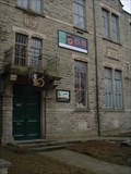 view gallery view gallery SE118.8 km SE118.8 km
|  The Boo, Waterfoot, Lancashire The Boo, Waterfoot, Lancashire
in Live Stage Theaters A theatre and theatre workshop for Horse + Bamboo Theatre. The co-ordinates are from the front of the building. posted by: Aldenbob location: North West England, United Kingdom date approved: 10/22/2008 last visited: 10/25/2008 |
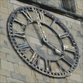 view gallery view gallerySW132.9 km |  St Patrick's Church Clock - Patrington, UK St Patrick's Church Clock - Patrington, UK
in Town Clocks The square tower on this church has a clock face on three sides of the tower. posted by: dtrebilc location: Yorkshire, United Kingdom date approved: 11/19/2021 last visited: never |
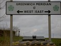 view gallery view gallerySW132.9 km |  Patrington, Humberside Meridian Marker Patrington, Humberside Meridian Marker
in Greenwich Meridian Markers On The B1445 to the east of Patrington, Humberside on the road to Spurn Head. posted by: splowe location: Yorkshire, United Kingdom date approved: 02/17/2007 last visited: 12/29/2015 |
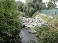
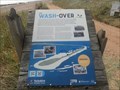 view gallery view gallerySW133.4 km |  The Wash-Over - Spurn Head, UK The Wash-Over - Spurn Head, UK
in UK Historical Markers Spurn Head is a narrow spit of land with the Humber estuary on one side and the North Sea on the over that is susceptible to storm damage. posted by: dtrebilc location: Yorkshire, United Kingdom date approved: 09/23/2021 last visited: never |
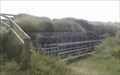 view gallery view gallerySW137.1 km |  Port War Signal Station - Spurn , UK Port War Signal Station - Spurn , UK
in World War I Sites This small fortiefied military base controlled the shipping lanes off the Humber Estuary at the entrance to the North Sea. posted by: dtrebilc location: Yorkshire, United Kingdom date approved: 11/17/2021 last visited: never |
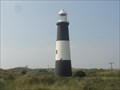 view gallery view gallerySW137.3 km | Spurn Lighthouse - Spurn Head, UK in Coastal Lighthouses This lighthouse was built in 1895 and replaced two earlier ones. posted by: dtrebilc location: Yorkshire, United Kingdom date approved: 09/21/2021 last visited: never |
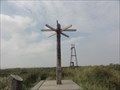 view gallery view gallerySW138.2 km |  Direction Arrows - Spurn Point, UK Direction Arrows - Spurn Point, UK
in Direction and Distance Arrows The direction arrows are at Spurn Point posted by: dtrebilc location: Yorkshire, United Kingdom date approved: 09/21/2021 last visited: never |
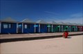 view gallery view gallerySW155.8 km |  Mablethorpe in Lincolnshire UK Mablethorpe in Lincolnshire UK
in Beach Huts Beach huts in Mablethorpe posted by: V70PDB location: East Midlands, United Kingdom date approved: 04/14/2007 last visited: 03/09/2008 |
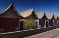 view gallery view gallerySW156.1 km | Beach Huts at Trusthorpe Lincolnshire UK in Beach Huts Beach Huts at Trusthorpe in Lincolnshire posted by: V70PDB location: East Midlands, United Kingdom date approved: 05/11/2007 last visited: 10/22/2011 |
 view gallery view gallerySW159.2 km |  Former Ticklepenny's Lock On Louth Navigation - Keddington, UK Former Ticklepenny's Lock On Louth Navigation - Keddington, UK
in Waterway Locks, Planes and Lifts This lock was the third lock on the Louth Navigation. posted by: dtrebilc location: Eastern England, United Kingdom date approved: 09/24/2021 last visited: never |
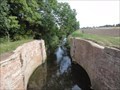
 view gallery view gallerySW159.8 km | Former Keddington Church Lock On Louth Navigation - Keddington, UK in Waterway Locks, Planes and Lifts This lock was the second lock on the Louth Navigation posted by: dtrebilc location: Eastern England, United Kingdom date approved: 09/24/2021 last visited: never |
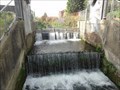 view gallery view gallerySW160.3 km | Former Town Lock On The Louth Navigation - Louth, UK in Waterway Locks, Planes and Lifts This lock was the first lock on the Louth Navigation in the town of Louth. posted by: dtrebilc location: Yorkshire, United Kingdom date approved: 09/24/2021 last visited: never |
|