 view gallery view gallery S3.9 km S3.9 km
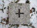
|   TP am geographischen Mittelpunkt Schleswig-Holsteins - Nortorf, Schleswig-Holstein, Germany TP am geographischen Mittelpunkt Schleswig-Holsteins - Nortorf, Schleswig-Holstein, Germany
in German Trigonometric Points [DE] Trigonometrischer Punkt am geographischen Mittelpunkt Schleswig-Holsteins.
[EN] Trigonometric point at the geographical center of Schleswig-Holstein. posted by:  king.hubi king.hubi location: Schleswig-Holstein, Germany date approved: 02/03/2013 last visited: 09/02/2020 |
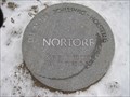 view gallery view galleryS3.9 km |  N.B.54°11'07.9353" Ö.L.9°49'19.5452" Die Mitte Schleswig-Holsteins, Nortorf, Germany N.B.54°11'07.9353" Ö.L.9°49'19.5452" Die Mitte Schleswig-Holsteins, Nortorf, Germany
in Permanent Geographic Coordinates [DE] Geographischer Mittelpunkt Schleswig-Holsteins.
[EN] Geographical Center of Schleswig-Holstein. posted by: king.hubi location: Schleswig-Holstein, Germany date approved: 02/03/2013 last visited: 09/02/2020 |
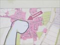
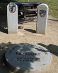 view gallery view galleryS3.9 km |  Der geographische Mittelpunkt Schleswig-Holsteins Der geographische Mittelpunkt Schleswig-Holsteins
in Geographical Centers Der geographische Mittelpunkt Schleswig-Holsteins befindet sich im Ortsteil Thienbüttel der Stadt Nortorf im Kreis Rendsburg-Eckernförde. posted by: KBreker location: Schleswig-Holstein, Germany date approved: 02/07/2011 last visited: 01/26/2020 |
 view gallery view gallery SE6.4 km SE6.4 km
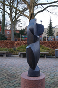
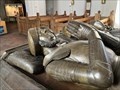
|  Figur Nortorf - SH, Germany Figur Nortorf - SH, Germany
in Abstract Public Sculptures [DE] abstrackte Frauenfigur vor der Post in Nortorf
[ENG] abstract female figure in front of the post office in Nortorf posted by: EDTA location: Schleswig-Holstein, Germany date approved: 03/06/2016 last visited: 09/02/2020 |
 view gallery view gallery NW11.4 km NW11.4 km
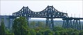
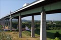
|  Rendsburger Hochbrücke mit Schwebefähre, Rendsburg, Germany Rendsburger Hochbrücke mit Schwebefähre, Rendsburg, Germany
in Engineering Landmarks Bei Eröffnung am 1. Oktober 1913 war sie die längste Eisenbahnbrücke Deutschlands und die kühnste und bedeutendste Stahlbaukonstruktion Europas *** At the time the Bridge was opened on 1 October 1913 it was the longest train bridge in Germany posted by: 4spring location: Schleswig-Holstein, Germany date approved: 11/23/2016 last visited: 09/11/2022 |
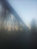 view gallery view galleryNW11.4 km |  Rendsburger Hochbrücke Rendsburger Hochbrücke
in Railroad Bridges Die Rendsburger Hochbrücke ist eine als Stahlkonstruktion in den Jahren 1911 bis 1913 erbaute Eisenbahnbrücke, die den Nord-Ostsee-Kanal überspannt. posted by: aendgraend location: Schleswig-Holstein, Germany date approved: 06/10/2019 last visited: 08/16/2024 |
 view gallery view gallery N12.7 km N12.7 km
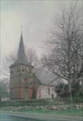
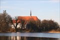
|  Maria-Magdalena-Kirche -Bovenau, Germany Maria-Magdalena-Kirche -Bovenau, Germany
in Picture Perfect Postcards [D] aus Feldsteinen errichtete Saalkirche stammt aus dem 13. Jahrhundert und Maria-Magdalena geweiht
[EN] single-nave hall church built with cobblestone dated back to the 16th century and consecrated Maria-Magdalena posted by: seapanda location: Schleswig-Holstein, Germany date approved: 09/24/2017 last visited: 07/04/2020 |
 view gallery view galleryN12.9 km |  Maria-Magdalenen-Kirche - Bovenau, Germany Maria-Magdalenen-Kirche - Bovenau, Germany
in Lutheran Churches [D] aus Feldsteinen errichtete Saalkirche stammt aus dem 13. Jahrhundert und Maria-Magdalena geweiht
[EN] single-nave hall church built with cobblestone dated back to the 16th century and consecrated Maria-Magdalena posted by: seapanda location: Schleswig-Holstein, Germany date approved: 09/13/2017 last visited: 07/04/2020 |
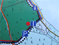
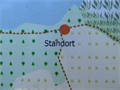
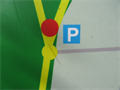 view gallery view galleryS12.9 km |  Viertshöher Moor, Naturschutzring Aukrug e.V. - SH, Germany Viertshöher Moor, Naturschutzring Aukrug e.V. - SH, Germany
in 'You Are Here' Maps [DE] eine Karte mit dem eigenen Standort am Parkplatz am Wanderweg am Viertshöher Moor
[ENG] a map with the own location at a parking lot at a hiking trail through "Viertshöher Moor" posted by: EDTA location: Schleswig-Holstein, Germany date approved: 04/14/2016 last visited: 05/04/2018 |
 view gallery view galleryN13.5 km |  Europabrücke (Rendsburg), Germany Europabrücke (Rendsburg), Germany
in Wikipedia Entries Die Europabrücke ist eine 1498 m (4913 ft) lange Brücke, die im Zuge der Bundesautobahn 7 den Nord-Ostsee-Kanal überquert.
This bridge is about 4913 feet long and goes oner the Nord-Ostsee-Kanal near by Rendsburg. posted by: Herzilein location: Schleswig-Holstein, Germany date approved: 03/18/2013 last visited: 03/31/2021 |
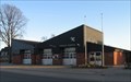 view gallery view galleryNW14 km |  Freiwillige Feuerwehr Borgstedt Freiwillige Feuerwehr Borgstedt
in Firehouses Gerätehaus in Borgstedt posted by:  CA* CA* location: Schleswig-Holstein, Germany date approved: 10/20/2011 last visited: 05/11/2017 |
 view gallery view gallery E14.3 km E14.3 km
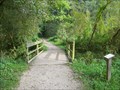
|  Brücke am Bordesholmer Ökopfad, SH, Germany Brücke am Bordesholmer Ökopfad, SH, Germany
in Hiking Path Footbridges [DE] Eine Brücke um einen kleinen Bach auf dem Bordesholmer Ökopfad zu überqoeren. [ENG] A bridge to cross a small stream at the "Bordesholmer Ökopfad". posted by: EDTA location: Schleswig-Holstein, Germany date approved: 10/07/2015 last visited: 11/12/2015 |
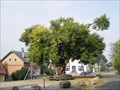 view gallery view galleryE14.5 km |  Bordesholmer Linde, SH, Germany Bordesholmer Linde, SH, Germany
in Exceptional Trees [DE] Diese ca. 700 Jahre alte Linde ist einer der ältesten Bäume in Schleswig Holstein.
[ENG] This about 700 year old lime tree is one of the oldest trees in Schleswig Holstein. posted by: EDTA location: Schleswig-Holstein, Germany date approved: 10/31/2015 last visited: 10/30/2017 |
 view gallery view galleryE14.5 km |  Frederick I. of Denmark - Bordesholm, SH, D Frederick I. of Denmark - Bordesholm, SH, D
in Grave of a Famous Person Frederick I (Danish and Norwegian: Frederik; German: Friedrich; Swedish: Fredrik; 7 October 1471 – 10 April 1533) was King of Denmark and Norway.
His tomb with his wife is in Bordesholm Abbey near Kiel. posted by: André de Montbard location: Schleswig-Holstein, Germany date approved: 02/25/2024 last visited: never |
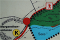
 view gallery view galleryE14.5 km | FFH-Gebiet ,,Wald am Bordesholmer See" - SH, Germany in 'You Are Here' Maps [DE] eine Karte mit dem eigenen Standort am Parkplatz im FFH-Naturschutzgrebiet Bordesholmer See [ENG] a map with the own location on the parking area in the nature reserve "Bordesholmer See" posted by: EDTA location: Schleswig-Holstein, Germany date approved: 04/18/2016 last visited: 05/18/2018 |
 view gallery view galleryE14.5 km |  Bordesholmer Kloster Bordesholmer Kloster
in Abbeys, Convents and Monasteries Das ehemalige Bordesholmer Kloster mit einer gotischen Hallenkirche der Augustiner Chorherren. Heute wird es als Ev.-Luth. Kirche und für kulturelle Veranstaltungen genutzt. posted by: Chilihead68 location: Schleswig-Holstein, Germany date approved: 02/28/2011 last visited: 02/17/2024 |
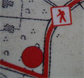 view gallery view gallerySE15.1 km | Karte am NSG am Einfelder See, Neumünster, SH, Germany in 'You Are Here' Maps [DE] Eine Karte mit dem eigenen Standort am Nordende des NSG am Wanderweg um den Einfelder See. [ENG] A map with your own position at the northern end of
nature reserve at the trail around the lake in Einfeld. posted by: EDTA location: Schleswig-Holstein, Germany date approved: 10/31/2015 last visited: 07/13/2022 |
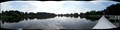
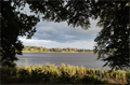 view gallery view gallerySE15.1 km |  Einfelder See - SH, Germany Einfelder See - SH, Germany
in Scenic Overlooks [DE] Rastplatz mit Ausblick am Wanderweg am Einfelder See
[ENG] Rest area with outlook at the trail on Einfelder See posted by: EDTA location: Schleswig-Holstein, Germany date approved: 01/15/2017 last visited: 07/13/2022 |
 view gallery view gallerySE15.1 km | Karte am NSG am Einfelder See, Neumünster, SH, Germany in 'You Are Here' Maps [DE] Eine Karte mit dem eigenen Standort am Südende des NSG am Wanderweg um den Einfelder See.
[ENG] A map with your own position at the southern end of nature reserve at the trail around the lake in Einfeld. posted by: EDTA location: Schleswig-Holstein, Germany date approved: 10/31/2015 last visited: 08/13/2019 |
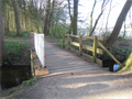 view gallery view galleryE15.1 km | Brücke am Bordesholmer Ökopfad - SH, Germany in Hiking Path Footbridges [DE] Eine Brücke um den Stintgraben, einen kleinen Bach auf dem Bordesholmer Ökopfad zu überqoeren. [ENG] A bridge to cross the "Stintgraben", a small stream at the "Bordesholmer Ökopfad". posted by: EDTA location: Schleswig-Holstein, Germany date approved: 04/19/2016 last visited: 05/18/2018 |
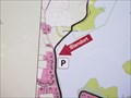 view gallery view gallerySE15.3 km | Karte am Einfelder See, Neumünster, SH, Germany in 'You Are Here' Maps [DE] Eine Karte mit dem eigenen Standort am Wanderweg am Einfelder See. [ENG] A map with your own position at the trail around the lake in Einfeld. posted by: EDTA location: Schleswig-Holstein, Germany date approved: 10/04/2015 last visited: 08/13/2019 |
 view gallery view gallerySE15.4 km | Karte am Nordeufer des Einfelder Sees, Neumünster, SH, Germany in 'You Are Here' Maps [DE] Eine Karte mit dem eigenen Standort am Wanderweg am Einfelder See. [ENG] A map with your own position at the trail around the lake in Einfeld. posted by: EDTA location: Schleswig-Holstein, Germany date approved: 10/05/2015 last visited: 08/17/2018 |
 view gallery view gallerySE15.4 km | Dorfbucht Mühbrook, Einfelder See - SH, Germany in Scenic Overlooks [DE] Blick über die Dorfbucht in Mühbrook
[ENG] View over the bay of "Einfelder See" in Mühbrook posted by: EDTA location: Schleswig-Holstein, Germany date approved: 09/17/2016 last visited: 08/17/2018 |
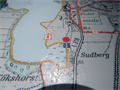
 view gallery view galleryE15.4 km | Standortkarte am Bordesholmer See - SH, Germany in 'You Are Here' Maps [DE] eine Karte mit dem eigenen Standort am Wanderweg am Bordesholmer See [ENG] a map with the own location at a hiking trail at "Bordesholmer See" posted by: EDTA location: Schleswig-Holstein, Germany date approved: 04/18/2016 last visited: 08/17/2018 |
 view gallery view galleryE15.6 km | FFH-Gebiet ,,Wald am Bordesholmer See" - SH, Germany in 'You Are Here' Maps [DE] eine Karte mit dem eigenen Standort am Wanderweg im FFH-Naturschutzgrebiet Bordesholmer See [ENG] a map with the own location on the trail in the nature reserve "Bordesholmer See" posted by: EDTA location: Schleswig-Holstein, Germany date approved: 04/18/2016 last visited: 08/17/2018 |
|