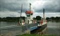
 view gallery view gallery W12.1 km W12.1 km
|   Kanalfähre Oldenbüttel - Oldenbüttel, S-H, Deutschland Kanalfähre Oldenbüttel - Oldenbüttel, S-H, Deutschland
in Ferries and Ferry Landings Spitzfährenanleger Oldenbüttel am Nord-Ostsee-Kanal in Schleswig-Holstein posted by:  Windschattenwanderer Windschattenwanderer location: Schleswig-Holstein, Germany date approved: 07/09/2017 last visited: 06/13/2022 |
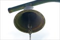 view gallery view galleryW12.1 km |  Rufglocke am Fähranleger - Oldenbüttel, S-H, Deutschland Rufglocke am Fähranleger - Oldenbüttel, S-H, Deutschland
in Bells Fähr-Rufglocke am Fähranleger Oldenbüttel in Schleswig-Holstein posted by: Windschattenwanderer location: Schleswig-Holstein, Germany date approved: 07/17/2017 last visited: never |
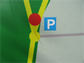
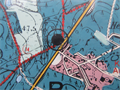
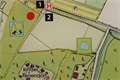
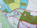 view gallery view gallery SE12.2 km SE12.2 km
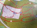
|  Karte am Boxberg, SH, Germany Karte am Boxberg, SH, Germany
in 'You Are Here' Maps [DE] Eine Karte mit dem eigenen Standort an einem Parkplatz am Boxberg. [ENG] A map with your own position at a parking area at "Boxberg". posted by: EDTA location: Schleswig-Holstein, Germany date approved: 10/13/2015 last visited: 08/22/2018 |
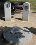 view gallery view gallery E12.4 km E12.4 km
|  Der geographische Mittelpunkt Schleswig-Holsteins Der geographische Mittelpunkt Schleswig-Holsteins
in Geographical Centers Der geographische Mittelpunkt Schleswig-Holsteins befindet sich im Ortsteil Thienbüttel der Stadt Nortorf im Kreis Rendsburg-Eckernförde. posted by: KBreker location: Schleswig-Holstein, Germany date approved: 02/07/2011 last visited: 01/26/2020 |
 view gallery view galleryE12.4 km |  N.B.54°11'07.9353" Ö.L.9°49'19.5452" Die Mitte Schleswig-Holsteins, Nortorf, Germany N.B.54°11'07.9353" Ö.L.9°49'19.5452" Die Mitte Schleswig-Holsteins, Nortorf, Germany
in Permanent Geographic Coordinates [DE] Geographischer Mittelpunkt Schleswig-Holsteins.
[EN] Geographical Center of Schleswig-Holstein. posted by: king.hubi location: Schleswig-Holstein, Germany date approved: 02/03/2013 last visited: 09/02/2020 |
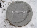
 view gallery view galleryE12.4 km |  TP am geographischen Mittelpunkt Schleswig-Holsteins - Nortorf, Schleswig-Holstein, Germany TP am geographischen Mittelpunkt Schleswig-Holsteins - Nortorf, Schleswig-Holstein, Germany
in German Trigonometric Points [DE] Trigonometrischer Punkt am geographischen Mittelpunkt Schleswig-Holsteins.
[EN] Trigonometric point at the geographical center of Schleswig-Holstein. posted by: king.hubi location: Schleswig-Holstein, Germany date approved: 02/03/2013 last visited: 09/02/2020 |
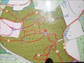
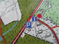
 view gallery view gallerySE12.7 km | Karte am höchsten Punkt des Boxberges, SH, Germany in 'You Are Here' Maps [DE] Eine Karte mit dem eigenen Standort an einem Parkplatz am Boxberg. [ENG] A map with your own position at a parking area at "Boxberg". posted by: EDTA location: Schleswig-Holstein, Germany date approved: 10/13/2015 last visited: 08/22/2018 |
 view gallery view gallerySE13 km | Karte am Boxberg, SH, Germany in 'You Are Here' Maps [DE] Eine Karte mit dem eigenen Standort an einem Parkplatz am Boxberg. [ENG] A map with your own position at a parking area at "Boxberg". posted by: EDTA location: Schleswig-Holstein, Germany date approved: 10/13/2015 last visited: 08/22/2018 |
 view gallery view gallerySE13 km | Viertshöher Moor, Naturschutzring Aukrug e.V. - SH, Germany in 'You Are Here' Maps [DE] eine Karte mit dem eigenen Standort am Parkplatz am Wanderweg am Viertshöher Moor
[ENG] a map with the own location at a parking lot at a hiking trail through "Viertshöher Moor" posted by: EDTA location: Schleswig-Holstein, Germany date approved: 04/14/2016 last visited: 05/04/2018 |
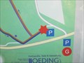 view gallery view gallerySE13.4 km | Karte am Boxberg, SH, Germany in 'You Are Here' Maps [DE] Eine Karte mit dem eigenen Standort an einem Parkplatz am Boxberg. [ENG] A map with your own position at a parking area at "Boxberg". posted by: EDTA location: Schleswig-Holstein, Germany date approved: 10/13/2015 last visited: 05/14/2018 |
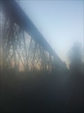
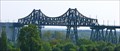 view gallery view gallery N14.3 km N14.3 km
|  Rendsburger Hochbrücke mit Schwebefähre, Rendsburg, Germany Rendsburger Hochbrücke mit Schwebefähre, Rendsburg, Germany
in Engineering Landmarks Bei Eröffnung am 1. Oktober 1913 war sie die längste Eisenbahnbrücke Deutschlands und die kühnste und bedeutendste Stahlbaukonstruktion Europas *** At the time the Bridge was opened on 1 October 1913 it was the longest train bridge in Germany posted by: 4spring location: Schleswig-Holstein, Germany date approved: 11/23/2016 last visited: 09/11/2022 |
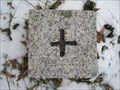
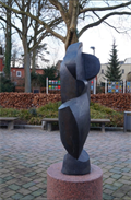 view gallery view galleryE14.5 km |  Figur Nortorf - SH, Germany Figur Nortorf - SH, Germany
in Abstract Public Sculptures [DE] abstrackte Frauenfigur vor der Post in Nortorf
[ENG] abstract female figure in front of the post office in Nortorf posted by: EDTA location: Schleswig-Holstein, Germany date approved: 03/06/2016 last visited: 09/02/2020 |
 view gallery view galleryN14.5 km |  Rendsburger Hochbrücke Rendsburger Hochbrücke
in Railroad Bridges Die Rendsburger Hochbrücke ist eine als Stahlkonstruktion in den Jahren 1911 bis 1913 erbaute Eisenbahnbrücke, die den Nord-Ostsee-Kanal überspannt. posted by: aendgraend location: Schleswig-Holstein, Germany date approved: 06/10/2019 last visited: 09/11/2022 |
 view gallery view gallerySE14.5 km | Naturpark Aukrug - SH, Germany in 'You Are Here' Maps [DE] eine Karte mit dem eigenen Standort am Parkplatz am Naturpark in Aukrug [ENG] a map with the own location at the parking area at the nature park in Aukrug posted by: EDTA location: Schleswig-Holstein, Germany date approved: 02/25/2018 last visited: 11/07/2020 |
 view gallery view gallerySE14.5 km | Naturschutz und Erholung in Aukrug - SH, Germany in 'You Are Here' Maps [DE] eine Karte mit dem eigenen Standort am Parkplatz am Naturschutzgebiet in Aukrug [ENG] a map with the own location at the parking area at the nature reserve in Aukrug posted by: EDTA location: Schleswig-Holstein, Germany date approved: 04/18/2016 last visited: 05/14/2018 |
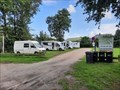 view gallery view galleryN15.1 km |  Freibad Fockbek - Fockbek, SH, Germany Freibad Fockbek - Fockbek, SH, Germany
in Free Overnight RV Parking Locations DE: Dieser Stellplatz befindet sich beim Freibad in Fockbek.
---
EN: This mobile home parking space is located at the outdoor pool in Fockbek. posted by: FamilieFrohne location: Schleswig-Holstein, Germany date approved: 08/08/2023 last visited: never |
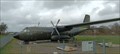 view gallery view gallery NW17.4 km NW17.4 km
|  Transall C-160D - Hohn, Germany Transall C-160D - Hohn, Germany
in Static Aircraft Displays Eine ausgemusterte Transall C-160D des Lufttransportgeschwaders 63 (LTG 63), ausgestellt auf einem Feld nahe des Fliegerhorsts Hohn. / A retired Transall C-160D of the Air Transport Wing 63, on display on a field near the airbase Hohn. posted by: Astartus location: Schleswig-Holstein, Germany date approved: 04/25/2024 last visited: never |
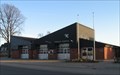 view gallery view galleryN18.8 km |  Freiwillige Feuerwehr Borgstedt Freiwillige Feuerwehr Borgstedt
in Firehouses Gerätehaus in Borgstedt posted by:  CA* CA* location: Schleswig-Holstein, Germany date approved: 10/20/2011 last visited: 05/11/2017 |
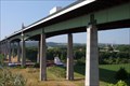 view gallery view galleryN19.3 km |  Europabrücke (Rendsburg), Germany Europabrücke (Rendsburg), Germany
in Wikipedia Entries Die Europabrücke ist eine 1498 m (4913 ft) lange Brücke, die im Zuge der Bundesautobahn 7 den Nord-Ostsee-Kanal überquert.
This bridge is about 4913 feet long and goes oner the Nord-Ostsee-Kanal near by Rendsburg. posted by: Herzilein location: Schleswig-Holstein, Germany date approved: 03/18/2013 last visited: 03/31/2021 |
 view gallery view gallerySE21.1 km |  Burger King - Aalbek - Neumunster, Germany Burger King - Aalbek - Neumunster, Germany
in Burger King Restaurants A Burger King Restaurant at the motorway station Aalbek posted by: Herzilein location: Schleswig-Holstein, Germany date approved: 03/18/2013 last visited: 03/26/2015 |
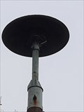 view gallery view gallery SW21.2 km SW21.2 km
|  Sirene an der Dorfstraße - Bokelrehm, SH, Germany Sirene an der Dorfstraße - Bokelrehm, SH, Germany
in Outdoor Warning Sirens DE: Auf einem Mast befindet sich eine Sirene an der Dorfstraße im Schleswig-Holsteinischen Ort Bokelrehm.
EN: There is a siren on a mast on Dorfstrasse in the Schleswig-Holstein town of Bokelrehm. posted by: FamilieFrohne location: Schleswig-Holstein, Germany date approved: 10/31/2021 last visited: 08/30/2023 |
 view gallery view gallerySE22 km |  Tierpark Neumünster Tierpark Neumünster
in Zoos Die Tierparkkasse hat täglich geöffnet:
Januar, Februar 09:00 - 16:00 Uhr
März 09:00 - 17:00 Uhr
April - August 09:00 - 18:00 Uhr
September, Oktober 09:00 - 17:00 Uhr
November, Dezember 09:00 - 16:00 Uhr posted by: Sebi Neumi location: Schleswig-Holstein, Germany date approved: 04/01/2013 last visited: 11/01/2015 |
 view gallery view gallerySE22.2 km | Karte am Stadwald Neumünster, SH, Germany in 'You Are Here' Maps [DE] Eine Karte mit dem eigenen Standort am Nordrand des Stadtwaldes von Neumünster. [ENG] A map with the own location on the northern edge of the city forest of Neumünster. posted by: EDTA location: Schleswig-Holstein, Germany date approved: 11/02/2015 last visited: 02/09/2016 |
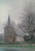 view gallery view gallery NE22.2 km NE22.2 km
|  Maria-Magdalena-Kirche -Bovenau, Germany Maria-Magdalena-Kirche -Bovenau, Germany
in Picture Perfect Postcards [D] aus Feldsteinen errichtete Saalkirche stammt aus dem 13. Jahrhundert und Maria-Magdalena geweiht
[EN] single-nave hall church built with cobblestone dated back to the 16th century and consecrated Maria-Magdalena posted by: seapanda location: Schleswig-Holstein, Germany date approved: 09/24/2017 last visited: 07/04/2020 |
 view gallery view galleryNE22.4 km |  Maria-Magdalenen-Kirche - Bovenau, Germany Maria-Magdalenen-Kirche - Bovenau, Germany
in Lutheran Churches [D] aus Feldsteinen errichtete Saalkirche stammt aus dem 13. Jahrhundert und Maria-Magdalena geweiht
[EN] single-nave hall church built with cobblestone dated back to the 16th century and consecrated Maria-Magdalena posted by: seapanda location: Schleswig-Holstein, Germany date approved: 09/13/2017 last visited: 07/04/2020 |
|