 view gallery view gallery NE2.4 km NE2.4 km
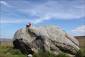
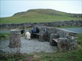
|   The Great Stone of Fourstones The Great Stone of Fourstones
in Places of Geologic Significance The Great Stone of Fourstones
This is an absolute cracker! It is HUGE and you can see it as you drive along the moor from Bentham. Fantastic views over to Ingleborough; climb up the carved steps and sit a-top this huge piece of stone and just gaze upon the view. A big old lump of rock in the middle of a very bleak and often featureless moor which makes it very hard to miss! posted by:  angellica angellica location: East Midlands, United Kingdom date approved: 07/17/2011 last visited: 12/12/2014 |
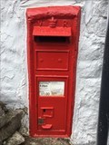
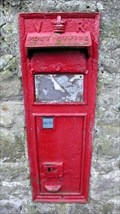
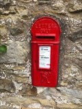 view gallery view galleryNE3.5 km |  Victorian Wall Post Box - High Bentham, Yorkshire, UK Victorian Wall Post Box - High Bentham, Yorkshire, UK
in Victorian Post Boxes A very rare Victorian lamp post box in High Bentham in Yorkshire posted by: ntpayne location: Yorkshire, United Kingdom date approved: 08/13/2018 last visited: never |
 view gallery view gallery N4.5 km N4.5 km
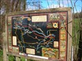
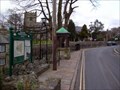
|  Bentham Heritage Trail, N Yorkshire Bentham Heritage Trail, N Yorkshire
in 'You Are Here' Maps Bentham Heritage Trail is marked out with a delightful series of geocaches. This is the map you need at the start at the cattle grid to St. Margaret Church. posted by: flipflopnick location: Yorkshire, United Kingdom date approved: 03/24/2008 last visited: 02/16/2009 |
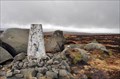
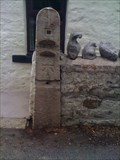 view gallery view galleryN5.1 km |  Toll Bar House Cut Benchmark. Low Bentham. North Yorkshire. UK Toll Bar House Cut Benchmark. Low Bentham. North Yorkshire. UK
in U.K. and Ireland Trigpoints Located on a gate stoop outside the Toll Bar house on the B6480, in between Wennington and Low Bentham. North Yorkshire. posted by:  thebigchip thebigchip location: United Kingdom date approved: 07/13/2009 last visited: never |
 view gallery view galleryN5.1 km |  Toll Bar House, Low Bentham. UK Toll Bar House, Low Bentham. UK
in Bygone Toll Houses Situated on the B6480 between Wennington and Low Bentham. This also is a waymark for a cut bench mark. posted by: thebigchip location: United Kingdom date approved: 07/13/2009 last visited: never |
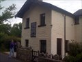
 view gallery view galleryN5.8 km |  Calf Cop Meeting House, Low Bentham Calf Cop Meeting House, Low Bentham
in Quaker Meeting Houses Calf Cop is still used as a Meeting House, with parking for three cars. There is a still active burial ground around the building. posted by: flipflopnick location: Yorkshire, United Kingdom date approved: 10/29/2009 last visited: never |
 view gallery view gallery S6.9 km S6.9 km
| Wolfhole Crag in U.K. and Ireland Trigpoints A pillar amongst weathered gritstone rocks at the summit of a remote hill in the Forest of Bowland. posted by: Happy Humphrey location: United Kingdom date approved: 03/10/2008 last visited: 06/14/2008 |
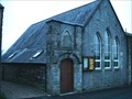 view gallery view galleryN9.3 km |  Westhouse Methodist church- Westhouse, Ingleton, Yorkshire England Westhouse Methodist church- Westhouse, Ingleton, Yorkshire England
in Methodist Churches The former Wesleyan chapel which is now a Methodist church can be found here in the small village of Lower Westhouse. posted by: fellsmanhiker location: Yorkshire, United Kingdom date approved: 01/20/2009 last visited: 02/10/2009 |
 view gallery view galleryNE9.5 km | Ingleton Village Map, N. Yorks in 'You Are Here' Maps On the parish council notice board is a village map. posted by: flipflopnick location: Yorkshire, United Kingdom date approved: 03/16/2008 last visited: 04/07/2012 |
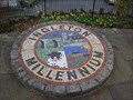 view gallery view galleryNE9.5 km |  Ingleton Millennium Garden, N. Yorks Ingleton Millennium Garden, N. Yorks
in Made for the Millennium Ingleton Millennium Garden is one of several projects in the village funded from Yorkshire Dales Millennium Trust. The millennium sign is a mosaic disc. posted by: flipflopnick location: Yorkshire, United Kingdom date approved: 03/17/2008 last visited: 04/09/2011 |
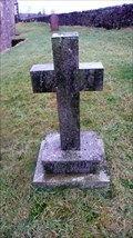
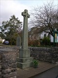 view gallery view galleryNE9.7 km |  Great War Memorial, Ingleton, N Yorks Great War Memorial, Ingleton, N Yorks
in World War I Memorials and Monuments This Celtic cross is on the side of Main Street, outside St Mary's parish church. posted by: flipflopnick location: Yorkshire, United Kingdom date approved: 03/16/2008 last visited: 04/07/2012 |
 view gallery view galleryN9.7 km | Victorian Wall Post Box - Thornton in Lonsdale, nr. Ingleton, Yorkshire, UK in Victorian Post Boxes A Victorian wall post box in Thornton in Lonsdale, near Ingleton in Yorkshire posted by: ntpayne location: Yorkshire, United Kingdom date approved: 08/13/2018 last visited: never |
 view gallery view galleryNE9.7 km |  Inglesport, N. Yorks Inglesport, N. Yorks
in Outdoor Recreation Stores Inglesport is THE caving specialist shop in the area. Run by cavers with an excellent cafe upstairs. posted by: flipflopnick location: Yorkshire, United Kingdom date approved: 03/26/2008 last visited: 11/30/2009 |
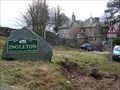 view gallery view galleryNE9.8 km |  Ingleton - Land of Caves and Waterfalls (N. Yorks) Ingleton - Land of Caves and Waterfalls (N. Yorks)
in Welcome Signs Ingleton is on the edge of limestone country, and a popular caving area with some show caves. posted by: flipflopnick location: Yorkshire, United Kingdom date approved: 03/17/2008 last visited: 04/07/2012 |
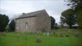
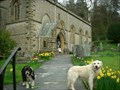 view gallery view galleryNE10.3 km |  St.James Parish church-Clapham village,Yorkshire Dales St.James Parish church-Clapham village,Yorkshire Dales
in This Old Church At the head of the famous village of Clapham in the Yorkshire Dales and sited dramatically on the Craven Fault stands the lofty spacious Parish church of St.James the apostle. posted by: fellsmanhiker location: United Kingdom date approved: 04/28/2008 last visited: 12/13/2009 |
 view gallery view gallery W10.9 km W10.9 km
|  Edith Caroline Rivett, Aughton, Lancashire Edith Caroline Rivett, Aughton, Lancashire
in Grave of a Famous Person Edith Caroline Rivett was a prolific detective crime authoress. She used many pseudonyms. Carol Carnac, E C R Lorac, Carol Rivett, Mary le Bourne. Her work has a dedicated following although no longer in print. posted by: flipflopnick location: North West England, United Kingdom date approved: 12/24/2012 last visited: never |
 view gallery view galleryN11.1 km | Thornton-in-Lonsdale Millennium viewpoint, Ingleton Yorkshire in Made for the Millennium This fine viewpoint was built to commemorate the millennium at Thornton-in-Lonsdale, near Ingleton. posted by: Tashington location: North West England, United Kingdom date approved: 01/19/2009 last visited: 02/10/2009 |
 view gallery view galleryN11.1 km |  Thornton in Lonsdale Orientation Table viewing station. Thornton in Lonsdale Orientation Table viewing station.
in Orientation Tables The Orientation table at this location identifies the surrounding fells of the Forest of Bowland and the Peaks of The Yorkshire Dales. posted by: fellsmanhiker location: United Kingdom date approved: 05/28/2008 last visited: 09/30/2008 |
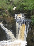 view gallery view galleryN11.1 km |  Pecca Twin Falls Ingleton England Pecca Twin Falls Ingleton England
in Waterfalls The third of the nine falls on the Ingleton Waterfalls Trail posted by: CEO44 location: North West England, United Kingdom date approved: 05/13/2015 last visited: never |
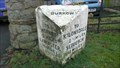 view gallery view galleryN11.4 km |  Burrow Road Milestone, Burrow, Lancashire Burrow Road Milestone, Burrow, Lancashire
in Milestones A large stone distance marker along the old Lancaster to Kirkby Stephen turnpike, showing distances to towns on route and current parish. Well cared for. Grade 2 listed structure. posted by: flipflopnick location: North West England, United Kingdom date approved: 01/17/2013 last visited: never |
 view gallery view galleryN11.4 km | Burrow Victorian Postbox, Lancashire in Victorian Post Boxes The Postbox is embedded in the wall of a barn at the junction of Woodman Lane and Burrow Road. LA6 151 posted by: flipflopnick location: North West England, United Kingdom date approved: 01/18/2013 last visited: never |
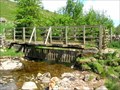 view gallery view galleryNE11.6 km |  Clapdale footbridge, North Yorkshire Clapdale footbridge, North Yorkshire
in Hiking Path Footbridges This wooden footbridge spans Clapham Beck. Steep field on one side, unsurfaced track on other side leading to Ingleborough fell. posted by: flipflopnick location: Yorkshire, United Kingdom date approved: 05/27/2008 last visited: 09/03/2014 |
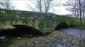 view gallery view galleryN11.7 km |  Burrow Bridge, Lancashire Burrow Bridge, Lancashire
in Stone Bridges Burrow Bridge is a fine stone bridge which carries the A683 main road over Leck Beck just before the river merges with the Lune River. posted by: flipflopnick location: North West England, United Kingdom date approved: 01/17/2013 last visited: never |
 view gallery view galleryN11.7 km |  Burrow Bridge - 1735 - Burrow, Lancashire Burrow Bridge - 1735 - Burrow, Lancashire
in Bridge Date Stones and Plaques Burrow Bridge has two dates inscribed in stone. When the bridge was rebuilt and widened in 1968, this replaced the earlier construction of 1735. The earlier supervisors and notaries name's are listed for the 1735 rebuild. Grade 2 listed structures. posted by: flipflopnick location: North West England, United Kingdom date approved: 01/19/2013 last visited: never |
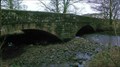 view gallery view galleryN11.7 km |  Burrow Bridge, Burrow, Lancashire Burrow Bridge, Burrow, Lancashire
in Arch Bridges Burrow Bridge has been here in many forms since before 1695 when it is shown on a map. The current structure is the result of re-widening in 1968. Bridge not a listed structure. posted by: flipflopnick location: North West England, United Kingdom date approved: 01/17/2013 last visited: never |
|