 view gallery view gallery E17.5 km E17.5 km
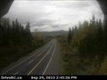
|   Francois Lake Ferry Landing Traffic Webcam - Burns Lake, BC Francois Lake Ferry Landing Traffic Webcam - Burns Lake, BC
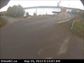
in Web Cameras Hwy 35 at Southbank ferry landing on Francois Lake. Another quick side trip - this time for a free ferry ride. We seldom pass up a chance for one of those. posted by:  T0SHEA T0SHEA location: British Columbia, Canada date approved: 10/01/2013 last visited: 01/10/2014 |
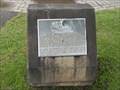
 view gallery view gallery NE36.2 km NE36.2 km
|  Tintagel Castle Stone - Tintagel, British Columbia, Canada Tintagel Castle Stone - Tintagel, British Columbia, Canada
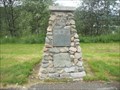
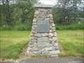
in Gifts from Other Countries A stone from the castle walls of Tintagel Castle in Cornwall, England, was given to its namesake city in British Columbia, Canada. posted by: Marine Biologist location: British Columbia, Canada date approved: 08/04/2013 last visited: 04/28/2019 |
 view gallery view galleryNE36.2 km |  Tintagel - Tintagel, British Columbia, Canada Tintagel - Tintagel, British Columbia, Canada
in UK Historical Markers A stone from the castle walls of Tintagel Castle in Cornwall, England, was given to its namesake city in British Columbia, Canada, and has an historical marker about it. posted by: Marine Biologist location: British Columbia, Canada date approved: 03/15/2014 last visited: 04/28/2019 |
 view gallery view galleryNE36.2 km |  Centennial Marker - Tintagel Rest Area - Tintagel, British Columbia, Canada Centennial Marker - Tintagel Rest Area - Tintagel, British Columbia, Canada
in Community Commemoration This Canadian centennial commemoration cairn includes a stone from the castle walls of Tintagel Castle in Cornwall, England, the namesake for this British Columbia city of Tintagel. posted by: Marine Biologist location: British Columbia, Canada date approved: 08/04/2013 last visited: 04/28/2019 |
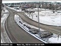
 view gallery view galleryNE42.2 km | Hwy 16 at Augier Rd Traffic Webcam - Burns Lake, BC in Web Cameras Hwy 16 at Augier Rd, about 22 km east of Burns Lake. posted by: T0SHEA location: British Columbia, Canada date approved: 10/01/2013 last visited: 01/14/2014 |
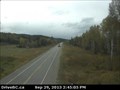
 view gallery view gallery N52.1 km N52.1 km
| Six Mile Hill Traffic Webcam - Burns Lake, BC in Web Cameras This is a relatively new camera, on Hiway 16, 40 km west of Burns Lake. posted by: T0SHEA location: British Columbia, Canada date approved: 10/04/2013 last visited: 01/14/2014 |
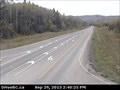
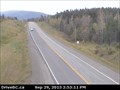
 view gallery view galleryE57.6 km | Savory Rest Area Traffic Webcam - Burns Lake, BC in Web Cameras Along Hwy 16 at a very welcome rest area about 48 km east of Burns Lake. According to the large sign at the rest area, we're entering "<i>The Lakes District</i>". posted by: T0SHEA location: British Columbia, Canada date approved: 10/01/2013 last visited: 01/14/2014 |
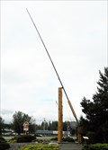 view gallery view gallery NW59.7 km NW59.7 km
|  LARGEST -- Fly Fishing Rod in the World LARGEST -- Fly Fishing Rod in the World
in Superlatives The city of Houston, British Columbia, which is known as the "Steelhead Capital" claims to have the world's largest fly fishing rod. The large fishing rod is located in Steelhead Park along Trans-Canada Yellowhead Highway 16. posted by: Marine Biologist location: British Columbia, Canada date approved: 08/10/2013 last visited: 06/24/2023 |
 view gallery view galleryNW59.7 km |  From Mexico to Canada - Houston, BC From Mexico to Canada - Houston, BC
in British Columbia Heritage Markers In 1983, this historic grinding stone was given to Equity Silver Mines Limited in British Columbia by its sister mine Minera Real de Angeles in Mexico. It's located in Steelhead Park in Houston, British Columbia. posted by: Marine Biologist location: British Columbia, Canada date approved: 08/12/2013 last visited: 06/24/2023 |
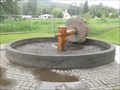 view gallery view galleryNW59.7 km |  Mexican Grinding Stone - Houston, BC, Canada Mexican Grinding Stone - Houston, BC, Canada
in Millstones In 1983, this historic grinding stone was given to Equity Silver Mines Limited in British Columbia by its sister mine Minera Real de Angeles in Mexico. It's located in Steelhead Park in Houston, British Columbia. posted by: Marine Biologist location: British Columbia, Canada date approved: 08/08/2013 last visited: 06/24/2023 |
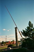 view gallery view galleryNW59.9 km |  Ginormous Fly Fishing Rod Ginormous Fly Fishing Rod
in Ginormous Everyday Objects A ginormous fly fishing rod in Houston, BC, the "Steelhead Capital of the World. posted by:  Hippie Kidz Hippie Kidz location: British Columbia, Canada date approved: 09/21/2007 last visited: 06/24/2023 |
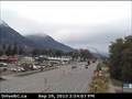
 view gallery view galleryNW70.7 km | Hungry Hill Traffic Webcam - Houston, BC in Web Cameras Hwy 16 at Anderson Road, 14 km NW of Houston. Another one of those places which make one wonder how they got their name. posted by: T0SHEA location: British Columbia, Canada date approved: 10/04/2013 last visited: 01/14/2014 |
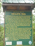 view gallery view galleryE88.7 km | Cheslatta Trail - Fraser Lake, BC in British Columbia Heritage Markers This marker about the Cheslatta Trail is located along the Trans-Canada Yellowhead Highway 16 near Fraser Lake, British Columbia. posted by: Marine Biologist location: British Columbia, Canada date approved: 08/07/2013 last visited: never |
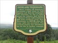 view gallery view galleryNW96.9 km | Overland Telegraph - Telkwa, BC in British Columbia Heritage Markers This marker about the Overland Telegraph is located along the Trans-Canada Yellowhead Highway 16 near Telkwa, British Columbia. posted by: Marine Biologist location: British Columbia, Canada date approved: 08/12/2013 last visited: never |
 view gallery view galleryNW96.9 km | WORST -- Insect Epidemic in British Columbia's History in Superlatives Although tapering off, the mountain pine beetle infestation of the lodgepole pine forests of British Columbia, was and continues to be the worst insect epidemic in British Columbia's history. posted by: Marine Biologist location: British Columbia, Canada date approved: 08/10/2013 last visited: never |
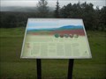
 view gallery view galleryNW96.9 km |  The Cycles of Nature - Telkwa, BC, Canada The Cycles of Nature - Telkwa, BC, Canada
in Flora and Fauna Information Signs This sign about the cycles of nature focuses on the mountain pine beetle infestation of the lodgepole pine forests of British Columbia. The sign is located at a rest area along the Trans-Canada Yellowhead Highway near Telkwa, British Columbia. posted by: Marine Biologist location: British Columbia, Canada date approved: 08/09/2013 last visited: never |
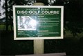 view gallery view galleryNW113 km |  Ranger Park Disk Golf Course - Smithers, BC Ranger Park Disk Golf Course - Smithers, BC
in Disc Golf Courses This is the most northern course in British Columbia. posted by: Hippie Kidz location: British Columbia, Canada date approved: 03/26/2009 last visited: never |
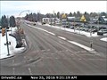 view gallery view galleryNW113.6 km | Smithers East Traffic Webcam - Smithers, BC in Web Cameras This is one of four cameras in a pod in the town of Smithers on Hiway 16 at Main Street. posted by: T0SHEA location: British Columbia, Canada date approved: 12/02/2016 last visited: never |
 view gallery view galleryNW113.6 km | Smithers North Traffic Webcam - Smithers, BC in Web Cameras This is one of four cameras in a pod in the town of Smithers on Hiway 16 at Main Street. posted by: T0SHEA location: British Columbia, Canada date approved: 12/02/2016 last visited: never |
 view gallery view galleryNW113.6 km | Smithers South Traffic Webcam - Smithers, BC in Web Cameras This is one of four cameras in a pod in the town of Smithers on Hiway 16 at Main Street. posted by: T0SHEA location: British Columbia, Canada date approved: 12/02/2016 last visited: never |
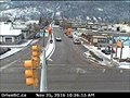
 view gallery view galleryNW113.8 km | Smithers Traffic Webcam - Smithers, BC in Web Cameras In the town of Smithers on Hiway 16 at Main Street, looking west. Pretty much self explanatory. posted by: T0SHEA location: British Columbia, Canada date approved: 10/04/2013 last visited: 01/14/2014 |
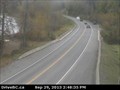 view gallery view galleryNW133.7 km | Hiway 16 at Trout Creek Traffic Webcam - Smithers, BC in Web Cameras Hiway 16 at the Trout Creek bridge, about 20 km. northwest of Smithers. What are the odds that this is a good place to get one's flies wet, or for drowning worms? posted by: T0SHEA location: British Columbia, Canada date approved: 10/04/2013 last visited: 01/14/2014 |
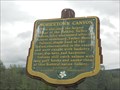 view gallery view galleryNW140.3 km | Moricetown Canyon - Moricetown, BC in British Columbia Heritage Markers This marker about the Moricetown Canyon is located along the Trans-Canada Yellowhead Highway 16 near Moricetown, British Columbia. posted by: Marine Biologist location: British Columbia, Canada date approved: 08/07/2013 last visited: 03/02/2023 |
|