 view gallery view gallery S7.7 km S7.7 km
|   Lancaster Bomber ED393 VN-K - Canal Head, UK Lancaster Bomber ED393 VN-K - Canal Head, UK
in Plane Crash Sites This simple marker stone marks the spot where Lancaster Bomber ED393 VN-K crashed during the Second World wat at the end of the Pocklington Canal just outside Pocklington. posted by:  dtrebilc dtrebilc location: Yorkshire, United Kingdom date approved: 10/26/2020 last visited: never |
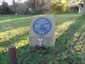
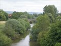
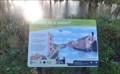 view gallery view galleryS7.9 km |  Pocklington Canal - Canal Head, UK Pocklington Canal - Canal Head, UK
in UK Historical Markers This information board at the start of the Pocklington Canal tells the history of the canal. posted by: dtrebilc location: Yorkshire, United Kingdom date approved: 10/26/2020 last visited: never |
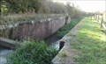
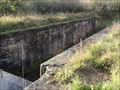
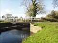
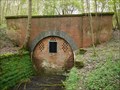
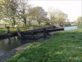 view gallery view galleryS7.9 km |  Top Lock On The Pocklington Canal - Canal Head,UK Top Lock On The Pocklington Canal - Canal Head,UK
in Waterway Locks, Planes and Lifts This lock is the highest Lock on the Pocklington Canal and is on the un-navigable section of the Canal. posted by: dtrebilc location: Yorkshire, United Kingdom date approved: 10/27/2020 last visited: never |
 view gallery view galleryS8.2 km | Silburn Lock On The Pocklington Canal - Allethorpe, UK in Waterway Locks, Planes and Lifts This lock is on the un-navigable section of the Pocklington Canal, but is accessible from the tow path that is still open along the whole length of the canal. posted by: dtrebilc location: Yorkshire, United Kingdom date approved: 10/27/2020 last visited: never |
 view gallery view gallery W8.4 km W8.4 km
|  Stamford Bridge Stamford Bridge
in Battlefields Fought between the armies of King Harold Godwinson of England and King Harald Hardrada of Norway this was the second major battle fought by the English in 1066 posted by:  reelcutter reelcutter location: Yorkshire, United Kingdom date approved: 02/28/2011 last visited: 10/28/2020 |
 view gallery view galleryS8.7 km | Giles Lock On The Pocklington Canal - Allethorpe, UK in Waterway Locks, Planes and Lifts This lock is on the un-navigable section of the Pocklington Canal, but is accessible from the tow path that is still open along the whole length of the canal. posted by: dtrebilc location: Yorkshire, United Kingdom date approved: 10/27/2020 last visited: never |
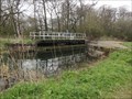
 view gallery view galleryS9.5 km | Sandhill Lock On The Pocklington Canal - Bielby, UK in Waterway Locks, Planes and Lifts This lock is on the un-navigable section of the Pocklington Canal, but is accessible from the tow path that is still open along the whole length of the canal. posted by: dtrebilc location: Yorkshire, United Kingdom date approved: 10/27/2020 last visited: never |
 view gallery view galleryS10 km | Coates Lock On The Pocklington Canal - Bielby, UK in Waterway Locks, Planes and Lifts This lock is on the un-navigable section of the Pocklington Canal, but is accessible from the tow path that is still open along the whole length of the canal. posted by: dtrebilc location: Yorkshire, United Kingdom date approved: 10/27/2020 last visited: never |
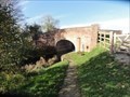
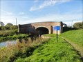
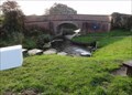 view gallery view galleryS10 km |  Coates Bridge - Bielby, UK Coates Bridge - Bielby, UK
in Arch Bridges This single arch brick bridge carries a minor road over the un-navigable section of the Pocklington Canal. posted by: dtrebilc location: Yorkshire, United Kingdom date approved: 10/29/2020 last visited: never |
 view gallery view gallery NE11.1 km NE11.1 km
|  Wharram Percy,deserted village.Yorkshire England. Wharram Percy,deserted village.Yorkshire England.
in Ghost Towns Wharram Percy,was once a thriving medieval community,it is now looked after by English Heritage and is open to the public to walk freely amongst the grounds and ruins. posted by: fellsmanhiker location: Yorkshire, United Kingdom date approved: 03/26/2008 last visited: 08/06/2023 |
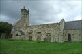
 view gallery view galleryNE11.1 km |  St.Martins church,Wharram Percy.Yorkshire England. St.Martins church,Wharram Percy.Yorkshire England.
in Medieval Churches The deserted village of Wharram Percy was once a thriving medieval community.The deserted village set on the side of a remote picturesque valley in the Yorkshire Wolds,was abandoned in 1500 leaving only the church,to serve for a further 400 years. posted by: fellsmanhiker location: United Kingdom date approved: 03/29/2008 last visited: 08/09/2023 |
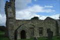 view gallery view galleryNE11.1 km |  Wharram Percy deserted village.Yorkshire UK. Wharram Percy deserted village.Yorkshire UK.
in English Heritage - Cadw - Historic Scotland The deserted village of Wharram Percy was once a thriving medieval community. The deserted village is set on the side of a remote picturesque valley of the Yorkshire Wolds.
posted by: fellsmanhiker location: United Kingdom date approved: 03/26/2008 last visited: 08/06/2023 |
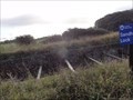
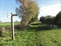
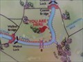 view gallery view galleryS11.1 km |  "You Are Here" At Swing Bridge 8 Over Pocklington Canal - Bileby, UK "You Are Here" At Swing Bridge 8 Over Pocklington Canal - Bileby, UK
in 'You Are Here' Maps The Pocklington Canal is 9.5 miles long and has a towpath along one side of the canal. This map is very close to swing bridge 8 over the canal. posted by: dtrebilc location: Yorkshire, United Kingdom date approved: 10/31/2020 last visited: never |
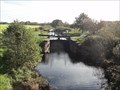
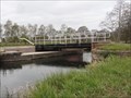
 view gallery view galleryS11.3 km |  Swing Bridge Number 8 On The Pocklington Canal - Bielby, UK Swing Bridge Number 8 On The Pocklington Canal - Bielby, UK
in Moving Bridges This swing bridge is the eastern most swing bridge on the Pocklington Canal and is an accommodation bridge for a nearby farm. posted by: dtrebilc location: Yorkshire, United Kingdom date approved: 05/08/2021 last visited: never |
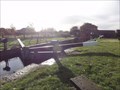
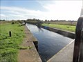
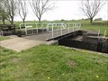
 view gallery view galleryS11.3 km | Walbut Lock On The Pocklington Canal - Bielby,UK in Waterway Locks, Planes and Lifts This lock was restored in 2018 and became the last navigable lock on the Pocklington Canal. posted by: dtrebilc location: Yorkshire, United Kingdom date approved: 05/18/2021 last visited: never |
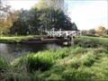
 view gallery view galleryS11.3 km | Walbut Bridge - Thornton, UK in Arch Bridges This single arch brick bridge carries a minor road over the navigable section of the Pocklington Canal. posted by: dtrebilc location: Yorkshire, United Kingdom date approved: 10/29/2020 last visited: never |
 view gallery view galleryS11.3 km | Thornton Lock On The Pocklington Canal - Thornton, UK in Waterway Locks, Planes and Lifts This lock is on the navigable section of the Pocklington Canal. posted by: dtrebilc location: Yorkshire, United Kingdom date approved: 05/18/2021 last visited: never |
 view gallery view galleryNE11.3 km |  Burdale Tunnel, E Yorkshire, UK Burdale Tunnel, E Yorkshire, UK
in Abandoned Train Tunnels The Burdale Tunnel was on the Malton & Driffield Junction Railway, is 1746 yards in length and passes beneath Wharram Percey Wold. posted by: Team Sieni location: North East England, United Kingdom date approved: 05/12/2010 last visited: 01/22/2017 |
 view gallery view galleryS11.4 km | Church Bridge - Thornton, UK in Arch Bridges This single arch brick bridge carries a minor road over the navigable section of the Pocklington Canal. posted by: dtrebilc location: Yorkshire, United Kingdom date approved: 10/31/2020 last visited: never |
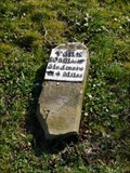 view gallery view galleryNE11.4 km |  Milestone, A166, Fimber, E Yorks UK Milestone, A166, Fimber, E Yorks UK
in Milestones A fine looking milestone that is marked on the current OS maps. Unfortunately it has been completely uprooted. It is to be hoped that it will be repaired soon. posted by: Team Sieni location: Yorkshire, United Kingdom date approved: 03/14/2012 last visited: never |
 view gallery view gallery SW11.6 km SW11.6 km
|  Pocklington Canal Distances - Melbourne, UK Pocklington Canal Distances - Melbourne, UK
in Direction and Distance Arrows This distance sign on the Pocklington Canal is almost at the half way point near to a marina at Melbourne. posted by: dtrebilc location: Yorkshire, United Kingdom date approved: 11/29/2020 last visited: never |
 view gallery view gallerySW11.6 km | Swing Bridge Number 7 On The Pocklington Canal - Melbourne, UK in Moving Bridges This swing bridge on the Pocklington Canal is next to an entrance to Melbourne marina and gives access to this and the village.. posted by: dtrebilc location: Yorkshire, United Kingdom date approved: 05/08/2021 last visited: never |
 view gallery view gallerySW11.6 km | Swing Bridge Number 6 On The Pocklington Canal - Melbourne, UK in Moving Bridges This swing bridge is an accommodation bridge for a nearby farm. posted by: dtrebilc location: Yorkshire, United Kingdom date approved: 05/08/2021 last visited: never |
 view gallery view gallerySW11.7 km | Swing Bridge Number 4 On The Pocklington Canal - Melbourne, UK in Moving Bridges This swing bridge on the Pocklington Canal was built as an accommodation bridge for a nearby farm. posted by: dtrebilc location: Yorkshire, United Kingdom date approved: 05/08/2021 last visited: never |
 view gallery view gallerySW11.9 km | Swing Bridge Number 3 On The Pocklington Canal - Storwood, UK in Moving Bridges This swing bridge is an accommodation bridge for a nearby farm. posted by: dtrebilc location: Yorkshire, United Kingdom date approved: 05/08/2021 last visited: never |
|