 view gallery view gallery SW0.2 km SW0.2 km
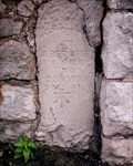
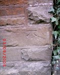
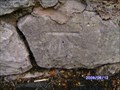
|   Mochdre, 369 # Conway Road Mochdre, 369 # Conway Road
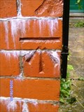
in U.K. and Ireland Trigpoints Cut mark: On stone gatepost E side road N side entrance of house No. 369 Conway Road, Mochdre, Conwy. posted by:  Meirion Meirion location: North Wales, United Kingdom date approved: 08/26/2009 last visited: never |
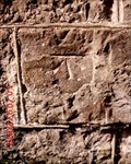
 view gallery view gallery S0.2 km S0.2 km
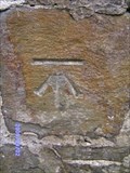
| Mochdre, Tanrallt Street in U.K. and Ireland Trigpoints Cut mark: On gatepost at junction of wall between the houses Pennant & Hathaway NW side road Tanrallt Street, Mochdre, Conwy. posted by: Meirion location: North Wales, United Kingdom date approved: 08/26/2009 last visited: never |
 view gallery view gallerySW0.3 km | Mochdre, Mountain View PH in U.K. and Ireland Trigpoints Cut mark: On the Mountain View Public House SW angle S face, Mochdre, Conwy. posted by: Meirion location: North Wales, United Kingdom date approved: 12/27/2007 last visited: never |
 view gallery view gallery N0.3 km N0.3 km
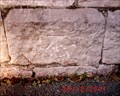
| Mochdre, Milestone in U.K. and Ireland Trigpoints Cut mark: On milestone SE side road Abergele 8 miles, Mochdre, Conwy. posted by: Meirion location: North Wales, United Kingdom date approved: 01/14/2008 last visited: never |
 view gallery view galleryN0.3 km |  Milestone on Conway Road, Mochdre, Conwy, Wales Milestone on Conway Road, Mochdre, Conwy, Wales
in Milestones A milestone in Mochdre, Conwy, Wales. posted by: Meirion location: North Wales, United Kingdom date approved: 09/14/2008 last visited: never |
 view gallery view galleryS0.5 km | Mochdre, Eglwys Nasareth in U.K. and Ireland Trigpoints Cut mark: On Nazareth Welsh Presbyterian Church E face 0.7m SE angle, Mochdre, Conwy. posted by: Meirion location: North Wales, United Kingdom date approved: 11/16/2008 last visited: never |
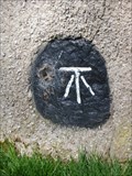
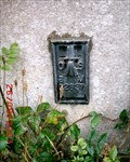 view gallery view gallery NE0.6 km NE0.6 km
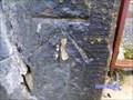
| Mochdre, Capel Seion in U.K. and Ireland Trigpoints Flush Bracket: On Seion Chapel (Now St. David's Catholic Church) NW face W angle, Mochdre, Conwy. posted by: Meirion location: North Wales, United Kingdom date approved: 09/26/2007 last visited: 09/26/2007 |
 view gallery view galleryN0.8 km | Bron-y-Nant, Old Hospital in U.K. and Ireland Trigpoints Cut mark: On building at Bron-y-Nant Hospital off Dinerth Road NE face E angle, Bron-y-Nant, Conwy. posted by: Meirion location: North Wales, United Kingdom date approved: 08/12/2009 last visited: never |
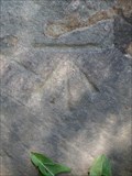
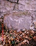
 view gallery view galleryS0.8 km |  Cut Mark - Mynydd Lane, Mochdre, Conwy, Wales Cut Mark - Mynydd Lane, Mochdre, Conwy, Wales
in European Historic Survey Stones, Monuments and Benchmarks An Ordnance Survey benchmark on Mynydd Lane, Mochdre, Conwy, Wales. posted by: Meirion location: North Wales, United Kingdom date approved: 03/22/2012 last visited: never |
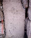
 view gallery view galleryS0.8 km | Cut Mark - Mynydd Lane, Mochdre, Conwy, Wales in U.K. and Ireland Trigpoints Cut mark: On large stone in wall on the N side of Mynydd Lane, Mochdre, Conwy, Wales. posted by: Meirion location: North Wales, United Kingdom date approved: 03/16/2012 last visited: never |
 view gallery view gallery E0.8 km E0.8 km
| Colwyn Bay, Old Highway #2 in U.K. and Ireland Trigpoints Cut mark: On wall S side Old Highway 6.8m E of gateway, Colwyn Bay, Conwy. posted by: Meirion location: North Wales, United Kingdom date approved: 09/05/2009 last visited: never |
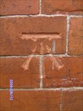
 view gallery view gallerySW1 km | Mochdre, Ty Gwyn Farm in U.K. and Ireland Trigpoints Flush Bracket: On outbuilding of Ty Gwyn Farm NW face W angle, Mochdre, Conwy. posted by: Meirion location: North Wales, United Kingdom date approved: 01/06/2008 last visited: never |
 view gallery view galleryN1 km | Bron-y-Nant, 39 # Dinerth Road in U.K. and Ireland Trigpoints Rivet: At the corner wall of No. 39 Dinerth Road at junction of Bodnant Road 0.5m SE of GPO marker, Bron-y-Nant, Conwy. posted by: Meirion location: North Wales, United Kingdom date approved: 08/12/2009 last visited: never |
 view gallery view gallery SE1 km SE1 km
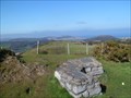
|  The View - Mochdre, Conwy, Wales The View - Mochdre, Conwy, Wales
in Scenic Overlooks A lookout spot known as The View above Mochdre, Conwy, Wales. posted by: Meirion location: North Wales, United Kingdom date approved: 03/15/2012 last visited: never |
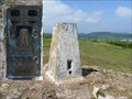
 view gallery view gallerySE1 km |  The View - Mochdre, Conwy, Wales The View - Mochdre, Conwy, Wales
in Orientation Tables An orientation table at the summit of The View, Mochdre, Conwy, Wales. posted by: Meirion location: North Wales, United Kingdom date approved: 03/15/2012 last visited: never |
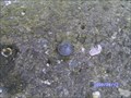
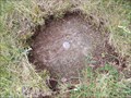
 view gallery view gallerySE1 km | Bolt - The View, Mochdre, Conwy, Wales in U.K. and Ireland Trigpoints Bolt: A triangulation bolt in a rocky outcrop at the summit of The View, Mochdre, Conwy, Wales. posted by: Meirion location: North Wales, United Kingdom date approved: 03/15/2012 last visited: never |
 view gallery view gallerySE1 km | Bolt - The View, Mochdre, Conwy, Wales in European Historic Survey Stones, Monuments and Benchmarks An Ordnance Survey bolt triangulation point located at The View, Mochdre, Conwy, Wales. posted by: Meirion location: North Wales, United Kingdom date approved: 03/18/2012 last visited: never |
 view gallery view galleryNE1.1 km | Colwyn Bay, Llanrwst Road in U.K. and Ireland Trigpoints Cut mark: On wall SW side Llanrwst Road at wall junction, Colwyn Bay, Conwy. posted by: Meirion location: North Wales, United Kingdom date approved: 09/15/2008 last visited: never |
 view gallery view galleryE1.1 km | Colwyn Bay, Old Highway in U.K. and Ireland Trigpoints Cut mark: On wall NE side Old Highway 4.7m NW of fence junction opposite, Colwyn Bay, Conwy. posted by: Meirion location: North Wales, United Kingdom date approved: 09/04/2009 last visited: never |
 view gallery view gallerySE1.1 km | Cut Mark - Mynydd-bach on Mynydd Lane, Mochdre, Conwy, Wales in U.K. and Ireland Trigpoints Cut mark: On boundary wall of house 'Mynydd-bach' on the N side of Mynydd Lane, Mochdre, Conwy, Wales. posted by: Meirion location: North Wales, United Kingdom date approved: 03/16/2012 last visited: never |
 view gallery view gallerySE1.1 km | Cut Mark - Mynydd-bach on Mynydd Lane, Mochdre, Conwy, Wales in European Historic Survey Stones, Monuments and Benchmarks An Ordnance Survey benchmark on Mynydd Lane, Mochdre, Conwy, Wales. posted by: Meirion location: North Wales, United Kingdom date approved: 03/22/2012 last visited: never |
 view gallery view gallery NW1.1 km NW1.1 km
| Surface Block - Bod-Ruffydd, Bryn Pydew, Conwy, Wales in U.K. and Ireland Trigpoints Surface Block: On the top of a grassy hill, Bryn Pydew, Conwy, Wales posted by: Meirion location: North Wales, United Kingdom date approved: 06/10/2011 last visited: never |
 view gallery view galleryN1.3 km | Bron-y-Nant, 98 # Dinerth Road in U.K. and Ireland Trigpoints Cut mark: On wall No. 98 Dinerth Road 6m NW of wall junction, Bron-y-Nant, Conwy. posted by: Meirion location: North Wales, United Kingdom date approved: 08/12/2009 last visited: never |
 view gallery view galleryNE1.3 km | Colwyn Bay, Tan -Y- Bryn Road #4 in U.K. and Ireland Trigpoints Cut mark: On wall W side Tan -Y- Bryn Road 1m N wall junction opposite, Colwyn Bay, Conwy. posted by: Meirion location: North Wales, United Kingdom date approved: 09/11/2008 last visited: never |
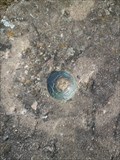
 view gallery view galleryN1.3 km | Triangulation Pillar - Bryn Euryn, Colwyn Bay, Conwy, Wales in European Historic Survey Stones, Monuments and Benchmarks An Ordnance Survey triangulation pillar located on the rocky summit of Bryn Euryn, Colwyn Bay, Conwy, Wales. posted by: Meirion location: North Wales, United Kingdom date approved: 12/01/2011 last visited: 04/07/2015 |
|