 view gallery view gallery N0.3 km N0.3 km
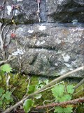
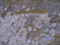
|   Llangaffo, Eglwys Sant Caffo Llangaffo, Eglwys Sant Caffo
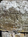
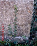
in U.K. and Ireland Trigpoints Cut mark: On SW face & 1m from W angle of the tower at Eglwys Sant Caffo, Llangaffo, Ynys Môn. posted by:  Meirion Meirion location: North Wales, United Kingdom date approved: 05/17/2010 last visited: never |
 view gallery view gallery NW1.3 km NW1.3 km
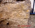
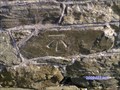
| Llangaffo, Railway Bridge in U.K. and Ireland Trigpoints Cut mark: On parapet of railway bridge on E side of the road 1.4m N angle wall, Llangaffo, Ynys Môn. posted by: Meirion location: North Wales, United Kingdom date approved: 05/17/2010 last visited: never |
 view gallery view gallery E1.8 km E1.8 km
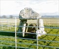
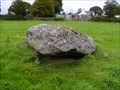
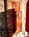
|  Bodowyr Burial Chamber, near Llangaffo, Ynys Môn, Wales Bodowyr Burial Chamber, near Llangaffo, Ynys Môn, Wales
in Megalithic Monuments A well preserved Burial Chamber, near Llangaffo, Ynys Môn, Wales. posted by: Meirion location: North Wales, United Kingdom date approved: 06/29/2007 last visited: 09/28/2009 |
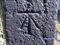
 view gallery view galleryNW1.9 km | Llangaffo, Pont Marquis in U.K. and Ireland Trigpoints Cut mark: On parapet of Pont Marquis SW side of road at corner of stream, Llangaffo, Ynys Môn. posted by: Meirion location: North Wales, United Kingdom date approved: 05/17/2010 last visited: never |
 view gallery view gallery SE2.1 km SE2.1 km
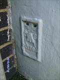
| Dwyran, Llys Newydd in U.K. and Ireland Trigpoints Flush Bracket: On E angle of SE face house Llys Newydd NW side of road, Dwyran, Ynys Môn. posted by: Meirion location: North Wales, United Kingdom date approved: 05/16/2010 last visited: never |
 view gallery view gallery S2.4 km S2.4 km
| Dwyran, Capel Dwyran in U.K. and Ireland Trigpoints Cut mark: On N angle of NE face of Capel Dwyran SE side of road, Dwyran, Ynys Môn. posted by: Meirion location: North Wales, United Kingdom date approved: 05/15/2010 last visited: never |
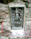
 view gallery view galleryS2.6 km | Llangeinwen, St. Ceinwen's Church in U.K. and Ireland Trigpoints Cut mark: On buttress at S angle of SW face of St. Ceinwen's Church, Llangeinwen, Ynys Môn. posted by: Meirion location: North Wales, United Kingdom date approved: 05/16/2010 last visited: never |
 view gallery view galleryS2.7 km | Dwyran, Primary School in U.K. and Ireland Trigpoints Flush Bracket: On N angle of local Primary School SE side of road, Dwyran, Ynys Môn. posted by: Meirion location: North Wales, United Kingdom date approved: 05/13/2010 last visited: never |
 view gallery view gallerySE3.1 km | Brynsiencyn, Penrhos Farm in U.K. and Ireland Trigpoints Flush Bracket: On building at Penrhos Farm SE side road NW face 2.1m N angle, Brynsiencyn, Ynys Môn. posted by: Meirion location: North Wales, United Kingdom date approved: 02/12/2008 last visited: never |
 view gallery view galleryE3.5 km | Brynsiencyn, Merddyn Gwyn Churn Stand in U.K. and Ireland Trigpoints Cut mark: On Churn-stand NE side Road 5m SE of entrance to Merddyn Gwyn, Brynsiencyn, Ynys Môn. posted by: Meirion location: North Wales, United Kingdom date approved: 09/28/2009 last visited: never |
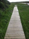 view gallery view galleryS3.7 km |  Stepping Stones and Boardwalk - Nr Dwyran, Anglesey, North Wales, UK Stepping Stones and Boardwalk - Nr Dwyran, Anglesey, North Wales, UK
in Coastal Boardwalks On the banks of the River Braint lies this boardwalk which leads to the large stepping stones across the water. The river feeds into the Menai Strait only a short distance away. posted by: Dragontree location: North Wales, United Kingdom date approved: 07/18/2012 last visited: never |
 view gallery view gallery W3.7 km W3.7 km
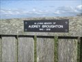
|  Audrey Broughton, The Cob, Malltraeth, Ynys Môn, Wales Audrey Broughton, The Cob, Malltraeth, Ynys Môn, Wales
in Dedicated Benches A dedicated bench to the memory of Audrey Broughton on the Cob in Malltraeth, Ynys Môn, Wales. posted by: Meirion location: North Wales, United Kingdom date approved: 04/10/2018 last visited: never |
 view gallery view galleryE3.7 km | Perthi-duon Burial Chamber, Brynsiencyn, Ynys Môn, Wales in Megalithic Monuments The remains of a burial chamber, Brynsiencyn, Ynys Môn, Wales. posted by: Meirion location: North Wales, United Kingdom date approved: 09/28/2009 last visited: never |
 view gallery view galleryW3.9 km | Malltraeth, Chapel in U.K. and Ireland Trigpoints On Chapel NE side High Street S angle SW face, Malltraeth, Ynys Môn. posted by: Meirion location: United Kingdom date approved: 02/01/2008 last visited: never |
 view gallery view galleryE3.9 km | Brynsiencyn, Capel Horeb in U.K. and Ireland Trigpoints Cut mark: On Capel Horeb on Tai Newydd S angle SE face, Brynsiencyn, Ynys Môn. posted by: Meirion location: North Wales, United Kingdom date approved: 02/12/2008 last visited: never |
 view gallery view gallerySE4 km |  Victorian Post Box, Brynsiencyn, Ynys Môn, Wales Victorian Post Box, Brynsiencyn, Ynys Môn, Wales
in Victorian Post Boxes The remains of a VR post box, near Brynsiencyn, Ynys Môn, Wales. posted by: Meirion location: North Wales, United Kingdom date approved: 02/12/2008 last visited: never |
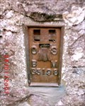
 view gallery view gallerySE4 km | Brynsiencyn, Ty Coch OSBM Bolt in U.K. and Ireland Trigpoints OSBM BOLT: On buttress of wall on the SE side of road 39m SW fence junction, Brynsiencyn, Ynys Môn. posted by: Meirion location: North Wales, United Kingdom date approved: 02/12/2008 last visited: never |
 view gallery view galleryE4 km | Brynsiencyn, Old School in U.K. and Ireland Trigpoints Flush Bracket: on the old school building on the W side road SE face 1.8m E angle, Brynsiencyn, Ynys Môn. posted by: Meirion location: North Wales, United Kingdom date approved: 02/12/2008 last visited: never |
 view gallery view gallery NE4.3 km NE4.3 km
| Gaerwen, Old Railway Bridge in U.K. and Ireland Trigpoints Cut mark: On the parapet of old railway bridge W side road 3m S of fence junction, Gaerwen, Ynys Môn. posted by: Meirion location: North Wales, United Kingdom date approved: 04/10/2009 last visited: never |
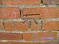
 view gallery view galleryE4.5 km | Brynsiencyn, St Nidan's Church in U.K. and Ireland Trigpoints Cut mark: On St Nidan's Church NE face 0.8m E angle, Brynsiencyn, Ynys Môn. posted by: Meirion location: North Wales, United Kingdom date approved: 02/12/2008 last visited: never |
 view gallery view galleryNE4.7 km | Pentre Berw, Eglwys Berea in U.K. and Ireland Trigpoints Cut mark: On gatepost NW side road 1.7m SW production SW face of chapel, Pentre Berw, Ynys Môn. posted by: Meirion location: North Wales, United Kingdom date approved: 08/01/2007 last visited: 08/01/2007 |
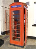 view gallery view galleryNE4.8 km |  Red Kiosk, near Level Crossing, Gaerwen, Ynys Môn, Wales. Red Kiosk, near Level Crossing, Gaerwen, Ynys Môn, Wales.
in Red Telephone Boxes A red kiosk in Gaerwen, Ynys Môn, Wales. posted by: Meirion location: North Wales, United Kingdom date approved: 03/21/2009 last visited: 03/18/2020 |
 view gallery view galleryNE4.8 km | Pentre Berw, Gatepost on Holyhead Road in U.K. and Ireland Trigpoints Cut mark: On gatepost NE side Holyhead Road at wall junction, Pentre Berw, Ynys Môn. posted by: Meirion location: North Wales, United Kingdom date approved: 04/13/2009 last visited: never |
 view gallery view galleryNE5 km | Gaerwen, Small Bridge in U.K. and Ireland Trigpoints Cut mark: On the parapet of small Bridge SW side Holyhead Road 5m NW wall junction, Gaerwen, Ynys Môn. posted by: Meirion location: North Wales, United Kingdom date approved: 04/08/2009 last visited: never |
 view gallery view galleryNE5 km | Gaerwen, Community Centre in U.K. and Ireland Trigpoints Cut mark: On community centre E side road NW face 1.2m N angle, Gaerwen, Ynys Môn. posted by: Meirion location: North Wales, United Kingdom date approved: 04/05/2009 last visited: never |
|