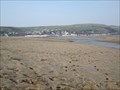
 view gallery view gallery SW1.6 km SW1.6 km
|   Ynyslas, Ceredigion, Wales, UK Ynyslas, Ceredigion, Wales, UK
in Wikipedia Entries Ynyslas is a sand beach with a large area of sand dunes at its centre, it forms a small peninsular at the north-west point of the county of Ceredigion. posted by:  Ddraig Ddu Ddraig Ddu location: South Wales, United Kingdom date approved: 04/04/2012 last visited: never |
 view gallery view gallerySW1.6 km |  Ynyslas Beach, Ceredigion, Wales, UK Ynyslas Beach, Ceredigion, Wales, UK
in Beaches Ynyslas is a sand beach with a large area of sand dunes at its centre, it forms a small peninsular at the north-west point of the county of Ceredigion. posted by: Ddraig Ddu location: South Wales, United Kingdom date approved: 04/04/2012 last visited: never |
 view gallery view gallerySW1.6 km |  Ynylsas National Park of Wales, Ceredigion, Wales, UK Ynylsas National Park of Wales, Ceredigion, Wales, UK
in National Parks of the World Ynyslas is a National Park of Wales and is built up of a sand beach with a large area of sand dunes at its centre, it forms a small peninsular at the north-west point of the county of Ceredigion. It is a wildlife reserve for endangered bird species. posted by: Ddraig Ddu location: South Wales, United Kingdom date approved: 04/16/2012 last visited: never |
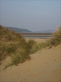 view gallery view gallerySW1.8 km |  Ynylsas National Park of Wales, Ceredigion, Wales, UK Ynylsas National Park of Wales, Ceredigion, Wales, UK
in Official Local Tourism Attractions Ynyslas is a National Park of Wales and is built up of a sand beach with a large area of sand dunes at its centre, it forms a small peninsular at the north-west point of the county of Ceredigion. It is a wildlife reserve for endangered bird species. posted by: Ddraig Ddu location: South Wales, United Kingdom date approved: 04/11/2012 last visited: never |
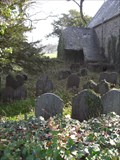 view gallery view gallery SE5 km SE5 km
|  Llancynfelin Grave Yard, Llancynfelin, Borth, Ceredigion, Wales, UK Llancynfelin Grave Yard, Llancynfelin, Borth, Ceredigion, Wales, UK
in Abandoned Cemeteries A grave yard located around an abandoned church (I believe it is St Johns). It is overgrown and many of the grave stones are hard to even read. posted by: Ddraig Ddu location: South Wales, United Kingdom date approved: 04/06/2011 last visited: never |
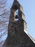 view gallery view gallerySE5 km |  Bell Tower, Abandoned Church, Llancynfelyn, Borth, Ceredigion, Wales Bell Tower, Abandoned Church, Llancynfelyn, Borth, Ceredigion, Wales
in Bell Towers A bell tower on an abandoned church in Llancynfelyn that looks to have not been used for at least ten years. The bell tower and bell still look in good condition, but I am unsure if they still work posted by: Ddraig Ddu location: South Wales, United Kingdom date approved: 06/19/2011 last visited: never |
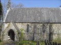 view gallery view gallerySE5 km |  Llancynfelin Church, Llancynfelin, Ceredigion, Wales, UK Llancynfelin Church, Llancynfelin, Ceredigion, Wales, UK
in Country Churches A church in Llancynfelin that looks in good condition, but is no longer in regular usage. It originally served a 18c and 19c community that prospered around a new nearby lead mine. posted by: Ddraig Ddu location: South Wales, United Kingdom date approved: 04/09/2011 last visited: never |
 view gallery view gallery S5.3 km S5.3 km
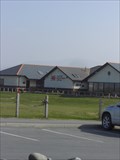
|  Borth & Ynyslas Golf Course, Borth, Ceredigion, Wales, UK Borth & Ynyslas Golf Course, Borth, Ceredigion, Wales, UK
in Public and Private Golf Courses A golf course in Borth posted by: Ddraig Ddu location: South Wales, United Kingdom date approved: 03/29/2011 last visited: never |
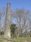 view gallery view gallerySE5.3 km |  Chimney, The Old Lead Mine, Llancynfelyn, Ceredigion, Wales, UK Chimney, The Old Lead Mine, Llancynfelyn, Ceredigion, Wales, UK
in Lonely Chimneys Near Llancynfelin in Ceredigion is a large complex of mine shafts and worked lodes which are believed to have been worked in the Roman period. Part of this lead to a 18m chimney being built, but has been out of use since at least the 1850's. posted by: Ddraig Ddu location: South Wales, United Kingdom date approved: 03/31/2011 last visited: never |
 view gallery view gallery NW5.5 km NW5.5 km
|  Salvation Army Drop Off, Car Park, Tywyn, Gwynedd, Wales, UK Salvation Army Drop Off, Car Park, Tywyn, Gwynedd, Wales, UK
in Permanent Charity Donation Locations A salvation army drop off box at the end of a car park in Tywyn, just off stations road. posted by: Ddraig Ddu location: North Wales, United Kingdom date approved: 07/04/2011 last visited: never |
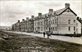 view gallery view galleryS5.5 km |  B4353 houses, Princes Street, Borth, Ceredigion, Wales, UK B4353 houses, Princes Street, Borth, Ceredigion, Wales, UK
in Photos Then and Now The houses in the picture have changed very little since the 1930's, although a few houses have popped up, and the sea defences have been vastly improved. posted by: Ddraig Ddu location: South Wales, United Kingdom date approved: 03/14/2011 last visited: never |
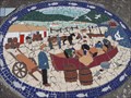
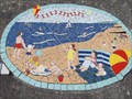 view gallery view galleryS5.6 km |  2000ad, Borth Time line - Princess Street, Borth, Ceredigion, Wales, UK 2000ad, Borth Time line - Princess Street, Borth, Ceredigion, Wales, UK
in Mosaics On the side of the flood defences in Borth is a 8000 year time line of the history and development of Borth. This one depicts the happy beach scheme of the modern day. Its is also a celebration of the year 2000 posted by: Ddraig Ddu location: South Wales, United Kingdom date approved: 03/13/2011 last visited: never |
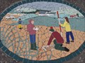 view gallery view galleryS5.6 km | 1997ad, Borth Time line - Princess Street, Borth, Ceredigion, Wales, UK in Mosaics On the side of the flood defences in Borth is a 8000 year time line of the history and development of Borth. This one depicts improvement done to the beach area and some work down to help reduce the effect of flooding. posted by: Ddraig Ddu location: South Wales, United Kingdom date approved: 03/13/2011 last visited: never |
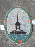 view gallery view galleryS5.6 km | 1983ad, Borth Time line - Princess Street, Borth, Ceredigion, Wales, UK in Mosaics On the side of the flood defences in Borth is a 8000 year time line of the history and development of Borth. This one shows the partial destruction of the monument on the nearby hill to the south of Borth. posted by: Ddraig Ddu location: South Wales, United Kingdom date approved: 03/13/2011 last visited: never |
 view gallery view galleryS5.6 km | 1900ad, Borth Time line - Princess Street, Borth, Ceredigion, Wales, UK in Mosaics On the side of the flood defences in Borth is a 8000 year time line of the history and development of Borth. This one depicts the nation dress of Wales for ladies to wear full gown and bonnets, a practice still done for some of St Davids day. posted by: Ddraig Ddu location: South Wales, United Kingdom date approved: 03/13/2011 last visited: never |
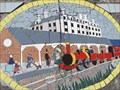 view gallery view galleryS5.6 km | 1880ad, Borth Time line - Princess Street, Borth, Ceredigion, Wales, UK in Mosaics On the side of the flood defences in Borth is a 8000 year time line of the history and development of Borth. This shows the introduction of a stop on the rail line in Borth in the 1880's posted by: Ddraig Ddu location: South Wales, United Kingdom date approved: 03/13/2011 last visited: never |
 view gallery view gallerySE5.6 km |  Cut Mark, A487, Tre'r Ddol, Ceredigion, Wales, UK Cut Mark, A487, Tre'r Ddol, Ceredigion, Wales, UK
in European Historic Survey Stones, Monuments and Benchmarks A cut mark on a mile stone on the east side of the A487 between Tre'r Ddol and Furnace in Ceredigion. posted by: Ddraig Ddu location: South Wales, United Kingdom date approved: 11/26/2011 last visited: never |
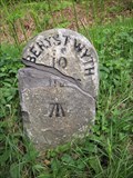 view gallery view gallerySE5.6 km |  Milestone, A487, Tre'r Ddol, Ceredigion, Wales, UK Milestone, A487, Tre'r Ddol, Ceredigion, Wales, UK
in Milestones A milestone on the A487 between Tre'r Ddol and Furnace that has at some point been decapitated and re-set. There is also a cut mark on it from the OS. posted by: Ddraig Ddu location: South Wales, United Kingdom date approved: 05/20/2011 last visited: never |
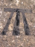 view gallery view gallerySE5.6 km |  Cut Mark, A487, Tre'r Ddol, Ceredigion, Wales, UK Cut Mark, A487, Tre'r Ddol, Ceredigion, Wales, UK
in U.K. and Ireland Trigpoints A cut mark on a mile stone on the east side of the A487 between Tre'r Ddol and Furnace in Ceredigion. posted by: Ddraig Ddu location: South Wales, United Kingdom date approved: 05/16/2011 last visited: never |
 view gallery view galleryS5.6 km | 1850ad, Borth Time line - Princess Street, Borth, Ceredigion, Wales, UK in Mosaics On the side of the flood defences in Borth is a 8000 year time line of the history and development of Borth. This one depicts the rise of the fish industry in the area with the popular Victorian holiday resort to the south of Aberystwyth. posted by: Ddraig Ddu location: South Wales, United Kingdom date approved: 03/13/2011 last visited: never |
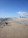 view gallery view galleryS5.6 km |  Borth Beach, Borth, Ceredigion, Wales, UK Borth Beach, Borth, Ceredigion, Wales, UK
in Rock-Hounding A public beach where you are allowed to take trinkets home, just don't fill your boot. posted by: Ddraig Ddu location: South Wales, United Kingdom date approved: 07/19/2011 last visited: 07/30/2013 |
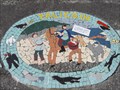
 view gallery view galleryS5.8 km | 1800ad, Borth Time line - Princess Street, Borth, Ceredigion, Wales, UK in Mosaics On the side of the flood defences in Borth is a 8000 year time line of the history and development of Borth. This depicts the three churches that were built here in the 1800's, each ones close to the centre of borth. posted by: Ddraig Ddu location: South Wales, United Kingdom date approved: 03/13/2011 last visited: never |
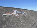
 view gallery view galleryS5.8 km | 1700ad, Borth Time line - Princess Street, Borth, Ceredigion, Wales, UK in Mosaics On the side of the flood defences in Borth is a 8000 year time line of the history and development of Borth. This one shows the myth that a evil sea hag drove the ship to run a ground near Borth posted by: Ddraig Ddu location: South Wales, United Kingdom date approved: 03/13/2011 last visited: never |
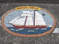
 view gallery view galleryS5.8 km | 1565ad, Borth Time line - Princess Street, Borth, Ceredigion, Wales, UK in Mosaics On the side of the flood defences in Borth is a 8000 year time line of the history and development of Borth. This one depicts the possible landing points for Spanish migrants. posted by: Ddraig Ddu location: South Wales, United Kingdom date approved: 03/13/2011 last visited: never |
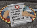
 view gallery view galleryS5.8 km | 1300ad, Borth Time line - Princess Street, Borth, Ceredigion, Wales, UK in Mosaics On the side of the flood defences in Borth is a 8000 year time line of the history and development of Borth. This one depicts the trade between here and the lime kilns in Taliesin. posted by: Ddraig Ddu location: South Wales, United Kingdom date approved: 03/13/2011 last visited: never |
|