 view gallery view gallery W1.1 km W1.1 km
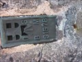
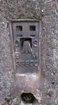
|   Flush Bracket, Plynmon Fawr, Ceredigion, Wales, UK Flush Bracket, Plynmon Fawr, Ceredigion, Wales, UK
in European Historic Survey Stones, Monuments and Benchmarks A flush bracket on a trig point pillar on the summit of Plymonfawr in Ceredigion. posted by:  Ddraig Ddu Ddraig Ddu location: South Wales, United Kingdom date approved: 07/27/2014 last visited: never |
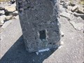 view gallery view galleryW1.1 km |  Triangulation Pillar - Plynmon Fawr, Ceredigion, Wales, UK Triangulation Pillar - Plynmon Fawr, Ceredigion, Wales, UK
in U.K. and Ireland Trigpoints A flush bracket on a trig point pillar on the summit of Plymonfawr in Ceredigion. posted by: Ddraig Ddu location: South Wales, United Kingdom date approved: 07/26/2014 last visited: never |
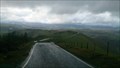
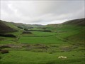 view gallery view gallery S4.2 km S4.2 km
|  Layby, A44, Eisteddfa Gurig, Ceredigion, Wales, UK Layby, A44, Eisteddfa Gurig, Ceredigion, Wales, UK
in Scenic Roadside Look-Outs A layby on the east side of a large flat valley near Eisteddfa Gurig. posted by: Ddraig Ddu location: South Wales, United Kingdom date approved: 11/14/2011 last visited: never |
 view gallery view galleryW4.5 km |  Windfarm Fast Tracked - Nant-y-Moch, Ceredigion, Wales, UK Windfarm Fast Tracked - Nant-y-Moch, Ceredigion, Wales, UK
in News Article Locations Furious protestors have been left devastated as controversial plans to build the biggest windfarm in Wales near Aberystwyth could now be pushed through by a new Bristol-based commission designed to fast-track major planning applications. posted by: Ddraig Ddu location: South Wales, United Kingdom date approved: 12/10/2011 last visited: never |
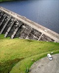
 view gallery view galleryW4.7 km |  Nant Y Moch Dam, Ponterwyd, Ceredigion, Wales Nant Y Moch Dam, Ponterwyd, Ceredigion, Wales
in Water Dams Nant-y-moch Dam and Reservoir was created in 1964. The construction of the dam flooded the valley south of it, which included the hamlet of Nant-y-moch. posted by: Ddraig Ddu location: South Wales, United Kingdom date approved: 12/26/2010 last visited: never |
 view gallery view gallery N8.5 km N8.5 km
| Wynford's View Point, Aberhosan, Powys, Wales, UK in Scenic Roadside Look-Outs A roadside layby with a circular dispay of the local peeks and a stunning view to boot posted by: Ddraig Ddu location: North Wales, United Kingdom date approved: 03/27/2016 last visited: never |
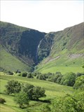 view gallery view gallery NW8.7 km NW8.7 km
|  Horsetail Falls, Glas Pwll, Ceredigion, Wales, UK Horsetail Falls, Glas Pwll, Ceredigion, Wales, UK
in Waterfalls Pistyll y Llyn is one of the tallest waterfalls in Wales. It is a horsetail type set of falls which are located in the Cambrian Mountains about 2 miles walk from Glaspwll in Powys, Wales to the north. posted by: Ddraig Ddu location: South Wales, United Kingdom date approved: 06/15/2011 last visited: 08/18/2015 |
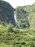 view gallery view galleryNW8.7 km |  Pistyll y Llyn, Horsetail Falls, Glas Pwll, Ceredigion, Wales, UK Pistyll y Llyn, Horsetail Falls, Glas Pwll, Ceredigion, Wales, UK
in Wikipedia Entries Pistyll y Llyn is one of the tallest waterfalls in Wales and the United Kingdom. It is a horsetail style set of falls which are located in the Cambrian Mountains about 4 km from Glaspwll in Powys, Wales. posted by: Ddraig Ddu location: South Wales, United Kingdom date approved: 01/18/2013 last visited: never |
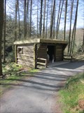
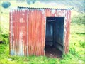 view gallery view galleryNW9 km |  Tin House, Waterfalls, Glas Pwll, Ceredigion, Wales, UK Tin House, Waterfalls, Glas Pwll, Ceredigion, Wales, UK
in Remote Backcountry Shelters A shelter at the base of a set of waterfalls a few miles south of Glas Pwll. Its use is unclear but as this is in a series of fields perhaps at one time it was used as an animal shelter. posted by: Ddraig Ddu location: South Wales, United Kingdom date approved: 06/22/2011 last visited: never |
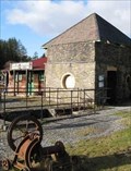
 view gallery view gallery SW9.2 km SW9.2 km
|  Silver Lead Mine, Llywernog, Ponterwyd, Aberystwyth, Ceredigion Silver Lead Mine, Llywernog, Ponterwyd, Aberystwyth, Ceredigion
in Official Local Tourism Attractions Llywernog Silver-Lead Mine is an award winning all weather tourist attraction in Mid Wales, close to Aberystwyth. It has guided tours, gold panning, tea rooms and gift shop all under the authority of the National Trust. posted by: Ddraig Ddu location: South Wales, United Kingdom date approved: 07/17/2011 last visited: never |
 view gallery view gallerySW9.2 km |  Silver Lead Mine, Llywernog, Ponterwyd, Aberystwyth, Ceredigion Silver Lead Mine, Llywernog, Ponterwyd, Aberystwyth, Ceredigion
in Mines Llywernog Silver-Lead Mine is an award winning all weather tourist attraction in Mid Wales, close to Aberystwyth. It has guided tours, gold panning, tea rooms and gift shop all under the authority of the National Trust. posted by: Ddraig Ddu location: South Wales, United Kingdom date approved: 01/23/2011 last visited: never |
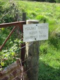 view gallery view galleryNW9.3 km |  Be Careful Young Trees, Glas Pwll, Machynlleth, Ceredigion, Wales, UK Be Careful Young Trees, Glas Pwll, Machynlleth, Ceredigion, Wales, UK
in Unintentionally Funny Signs A sign on the entrance to a small marsh area that has allot of trees on it. posted by: Ddraig Ddu location: South Wales, United Kingdom date approved: 09/24/2011 last visited: never |
 view gallery view gallerySW9.7 km | Wooden Shelter, Bwlch Nant Yr Arian, Ponterwyd, Ceredigion, Wales, UK in Remote Backcountry Shelters A wooden log cabin on a long circular walk from a car park at the nearby Nant Yr Arian walk. posted by: Ddraig Ddu location: South Wales, United Kingdom date approved: 03/25/2012 last visited: never |
 view gallery view galleryS10 km | Trigometric Pillar, Bryn Garw, Pen y Garn, Cwm Ystwyth, Ceredigion, Wales, UK in European Historic Survey Stones, Monuments and Benchmarks A trig Pillar on the top of Banc Garw on Pen y Garn. posted by: Ddraig Ddu location: North Wales, United Kingdom date approved: 03/29/2016 last visited: never |
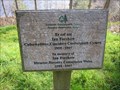
 view gallery view gallerySW10 km |  D.I Harris, Pondside, Bwlch Nant yr Arian, Ponterwyd, Ceredigion, Wales, UK D.I Harris, Pondside, Bwlch Nant yr Arian, Ponterwyd, Ceredigion, Wales, UK
in Dedicated Benches A dedicated chair, calling it a bench would be a bit of a push to be honest. posted by: Ddraig Ddu location: South Wales, United Kingdom date approved: 04/04/2012 last visited: never |
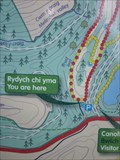
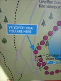 view gallery view gallerySW10 km |  Sign, Bwlch Nant Yr Arian, Ponterwyd, Ceredigion, Wales, UK Sign, Bwlch Nant Yr Arian, Ponterwyd, Ceredigion, Wales, UK
in 'You Are Here' Maps A sign showing your position relative to a series of walks around the two lakes in Bwlch Nant Yr Arian. posted by: Ddraig Ddu location: South Wales, United Kingdom date approved: 03/25/2012 last visited: never |
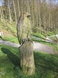 view gallery view gallerySW10 km |  Kestrel, Bwlch Nant yr Arian, Ponterwyd, Ceredigion, Wales, UK Kestrel, Bwlch Nant yr Arian, Ponterwyd, Ceredigion, Wales, UK
in Outside Wooden Display Carvings A wooden carving of a kestrel on the banks of the pond in Bwlch Nant yr Arian in the forestry commission site. posted by: Ddraig Ddu location: South Wales, United Kingdom date approved: 04/06/2012 last visited: never |
 view gallery view gallerySW10 km |  Ian Forshaw, Bwlch Nant yr Arian, Ponterwyd, Ceredigion, Wales, UK Ian Forshaw, Bwlch Nant yr Arian, Ponterwyd, Ceredigion, Wales, UK
in Dedicated Trees A dedicated tree to the memory of Ian Forshaw on the banks of the pond in Bwlch Nany yr Arian. posted by: Ddraig Ddu location: South Wales, United Kingdom date approved: 04/04/2012 last visited: never |
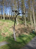 view gallery view gallerySW10 km |  Red Kite, Bwylsh Nant Yr Ariain, Ponterwyd, Ceredigion, Wales, UK Red Kite, Bwylsh Nant Yr Ariain, Ponterwyd, Ceredigion, Wales, UK
in Figurative Public Sculpture On the banks of the Nant Yr Arian pond area is a red kite sculpture made from iron and soaring to the east. posted by: Ddraig Ddu location: South Wales, United Kingdom date approved: 04/04/2012 last visited: never |
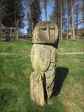 view gallery view gallerySW10 km | Owl, Bwlch Nant yr Arian, Ponterwyd, Ceredigion, Wales, UK in Outside Wooden Display Carvings A wooden carving on the side of a RSPCB shop in the shape of an owl. posted by: Ddraig Ddu location: South Wales, United Kingdom date approved: 04/06/2012 last visited: never |
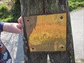
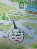 view gallery view gallerySW10.1 km | Sign, Bwlch Nant Yr Arian, Ponterwyd, Ceredigion, Wales, UK in 'You Are Here' Maps A sign with 'Rhydych chi yma' or 'you are here' in English on a look out point over the Bwlch Nant Yr Arian reserve and forestry commission site. posted by: Ddraig Ddu location: South Wales, United Kingdom date approved: 04/04/2012 last visited: never |
 view gallery view gallerySW10.1 km | Sign, Ridgeway, Bwlch Nant Yr Arian, Ponterwyd, Ceredigion, Wales, UK in 'You Are Here' Maps A sign showing your position relative to the two walks, the ridgeway and the 1 miles shorter walk to the west. posted by: Ddraig Ddu location: South Wales, United Kingdom date approved: 03/25/2012 last visited: never |
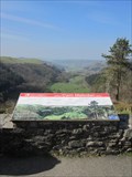 view gallery view gallerySW10.1 km |  Orientation Table, Bwlch Nant Yr Arian, Ponterwyd, Ceredigion, Wales, UK Orientation Table, Bwlch Nant Yr Arian, Ponterwyd, Ceredigion, Wales, UK
in Orientation Tables An orientation table on the view over the Rheidol valley, a view you can see over for 10 miles from this point to its mouth at Aberystwyth posted by: Ddraig Ddu location: South Wales, United Kingdom date approved: 03/28/2012 last visited: never |
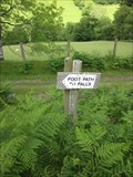
 view gallery view galleryNW10.1 km | Pride always come before a..?, Glas Pwll, Ceredigion, Wales, UK in Unintentionally Funny Signs A sign on the approach to the nearby waterfall after an approximate 1 miles walk over a T3 area. The sign clearly means that one should be walking to a set of waterfalls, but obviously could be misread as a footpath where one could fall over. posted by: Ddraig Ddu location: South Wales, United Kingdom date approved: 06/26/2011 last visited: never |
 view gallery view galleryNW10.3 km |  Falls Walk, Glas Pwll, Machynlleth, Ceredigion, Wales, UK Falls Walk, Glas Pwll, Machynlleth, Ceredigion, Wales, UK
in Self Guided Walks and Trails A self guided walk with some white topped stakes just to nudge you in the right direction. posted by: Ddraig Ddu location: South Wales, United Kingdom date approved: 06/15/2011 last visited: never |
|