 view gallery view gallery NW1.6 km NW1.6 km
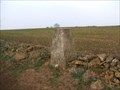
|   Illington Down Illington Down
in U.K. and Ireland Trigpoints Illington Down Trigpoint above Mickleton on the Gloucestershire/ Warwickshire border. posted by:  theblack theblack location: United Kingdom date approved: 12/17/2007 last visited: never |
 view gallery view gallery NE1.8 km NE1.8 km
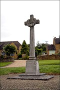
|  First World War Memorial, Ilmington, Warwickshire, UK First World War Memorial, Ilmington, Warwickshire, UK
in World War I Memorials and Monuments Ilmington War Memorial, Warwickshire. posted by:  Bear and Ragged Bear and Ragged location: West Midlands, United Kingdom date approved: 08/17/2008 last visited: never |
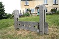 view gallery view galleryNE2.3 km |  Stocks -Ilmington, Warwickshire, UK Stocks -Ilmington, Warwickshire, UK
in Punishment and Disciplinary Devices Stocks. Village of Ilmington, Warwickshire. posted by: Bear and Ragged location: West Midlands, United Kingdom date approved: 06/04/2009 last visited: never |
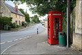 view gallery view galleryNW4.2 km |  Mickleton phone box, Gloucestershire, UK Mickleton phone box, Gloucestershire, UK
in Red Telephone Boxes Mickleton, Gloucestershire. posted by: Bear and Ragged location: Southern England, United Kingdom date approved: 07/27/2008 last visited: never |
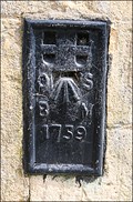
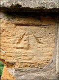
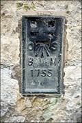 view gallery view galleryNW4.2 km | Flush Bracket, Mickleton, Gloucestershire, UK in U.K. and Ireland Trigpoints Flush Bracket, side of house, Mickleton, Gloucestershire. posted by: Bear and Ragged location: Southern England, United Kingdom date approved: 09/10/2008 last visited: 05/30/2014 |
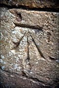 view gallery view galleryNW4.2 km | Cut Benchmark, Mickleton, Gloucestershire, UK in U.K. and Ireland Trigpoints Cut Benchmark, Mickleton, Gloucestershire. posted by: Bear and Ragged location: Southern England, United Kingdom date approved: 09/10/2008 last visited: never |
 view gallery view gallery N4.3 km N4.3 km
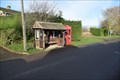
| Ted Telephone Box - Admington, Warwickshire, CV36 4JN in Red Telephone Boxes red box next to bus stop posted by: thek6project location: West Midlands, United Kingdom date approved: 01/12/2020 last visited: 01/10/2020 |
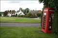 view gallery view galleryNW5 km | Upper Quinton, Warwickshire, UK in Red Telephone Boxes Upper Quinton, Warwickshire. posted by: Bear and Ragged location: West Midlands, United Kingdom date approved: 07/27/2008 last visited: 01/10/2020 |
 view gallery view gallery SW5.1 km SW5.1 km
| Flush Bracket, Chipping Campden, Gloucestershire, UK in U.K. and Ireland Trigpoints Flush Bracket, Chipping Campden, Gloucestershire. posted by: Bear and Ragged location: Southern England, United Kingdom date approved: 08/23/2008 last visited: 03/22/2020 |
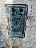 view gallery view gallerySW5.3 km | Flush Bracket - Wixey House, Chipping Campden, Gloucestershire in U.K. and Ireland Trigpoints Ordnance Survey flush bracket on Wixey House in Chipping Campden, Gloucestershire. posted by: JamesA60 location: West Midlands, United Kingdom date approved: 04/12/2020 last visited: never |
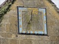
 view gallery view gallerySW5.3 km |  Grevel House Sundial, Chipping Campden, UK Grevel House Sundial, Chipping Campden, UK
in Sundials Grevel House has a square stone sundial dated 1815. Grevel House was the residence of William Gravel, a rich wool merchant in the 14th century. Grevel House is over 600 years old, perhaps the oldest house in Campden. posted by: arby101ca location: South West England, United Kingdom date approved: 08/13/2012 last visited: never |
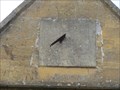
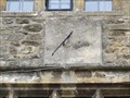
 view gallery view gallerySW5.5 km | Bookstore Sundial, Chipping Campden, UK in Sundials A circular sundial dated 1690 is on the recently closed bookstore on the High Street in Chipping Campden. The sundial is on a wedge to lower the declination. The 10 am substyle time indicates a declination of 26° posted by: arby101ca location: South West England, United Kingdom date approved: 08/13/2012 last visited: never |
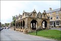 view gallery view gallerySW5.5 km |  Market Hall, Chipping Campden, Gloucestershire, UK Market Hall, Chipping Campden, Gloucestershire, UK
in National Trust U.K. Market Hall in Chipping Campden, Gloucestershire. posted by: Bear and Ragged location: Southern England, United Kingdom date approved: 08/23/2008 last visited: 03/22/2020 |
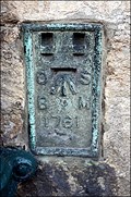
 view gallery view gallerySW5.5 km | Cut Benchmark, Market Hall, Chipping Campden, Gloucestershire in U.K. and Ireland Trigpoints Cut Benchmark, Market Hall, Chipping Campden. posted by: Bear and Ragged location: Southern England, United Kingdom date approved: 08/23/2008 last visited: never |
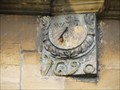
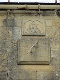
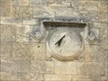 view gallery view gallerySW5.5 km | Sundial House Sundial, Chipping Campden, UK in Sundials There is the expected sundial on Sundial House on the High Street in Chipping Campden, near the Market Hall. This is a circular sundial dated 1647 declining about 35° east. posted by: arby101ca location: South West England, United Kingdom date approved: 08/13/2012 last visited: never |
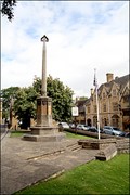 view gallery view gallerySW5.5 km | First World War Memorial, Chipping Campden, Gloucestershire, UK in World War I Memorials and Monuments First World War Memorial, Chipping Campden, Gloucestershire. posted by: Bear and Ragged location: Southern England, United Kingdom date approved: 08/23/2008 last visited: 03/22/2020 |
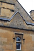 view gallery view gallerySW5.5 km |  1897 - Village Hall, Chipping Campden, Gloucestershire, UK 1897 - Village Hall, Chipping Campden, Gloucestershire, UK
in Dated Buildings and Cornerstones Village Hall in the Market Square. posted by: garmin_geek location: West Midlands, United Kingdom date approved: 05/07/2009 last visited: never |
 view gallery view gallerySW5.5 km |  Cotswold Way, Chipping Campden to Bath, Chipping Campden, Gloucestershire, UK Cotswold Way, Chipping Campden to Bath, Chipping Campden, Gloucestershire, UK
in Long Distance Hiking Trails Cotswold Way.
Chipping Campden to Bath. 100 miles. posted by: Bear and Ragged location: Southern England, United Kingdom date approved: 08/25/2008 last visited: 04/16/2009 |
 view gallery view gallerySW5.6 km | Cotswold House Hotel Sundial, Chipping Campden, UK in Sundials At the Cotswold House Hotel on the High Street of Chipping Campden is an intersting old sundial carved in stone and painted. The sundial is on the front of the building at the back, up a small lane. The dial declines about 51° east of south. posted by: arby101ca location: South West England, United Kingdom date approved: 08/13/2012 last visited: never |
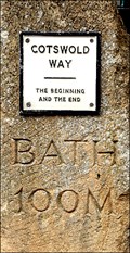
 view gallery view gallerySW5.6 km |  Cotswold Way, Chipping Campden, Gloucestershire, UK Cotswold Way, Chipping Campden, Gloucestershire, UK
in Hiking and walking trailheads Chipping Campden, Gloucestershire, UK is the Northern termunis of the 100 mile long Cotswold Way. The marker indicated "The beginning and the end" posted by: garmin_geek location: West Midlands, United Kingdom date approved: 05/06/2009 last visited: never |
 view gallery view gallerySW5.6 km | Dial House Sundial, Chipping Campden, UK in Sundials On Dial House on the High Street of Chipping Campden is an intersting old sundial carved in stone. The dial declines about 34° east of south. posted by: arby101ca location: South West England, United Kingdom date approved: 08/13/2012 last visited: never |
 view gallery view gallerySW5.6 km | Green Dragon House Sundial, Chipping Campden, UK in Sundials On Green Dragon House on the High Street of Chipping Campden is an intersting old sundial carved in stone. The dial declines about 45° east of south. The dial is dated 1700. posted by: arby101ca location: South West England, United Kingdom date approved: 08/13/2012 last visited: never |
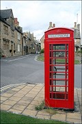 view gallery view gallerySW5.6 km | Chipping Campden phone box, Gloucestershire, UK in Red Telephone Boxes Chipping Campden, Gloucestershire. posted by: Bear and Ragged location: Southern England, United Kingdom date approved: 07/27/2008 last visited: never |
 view gallery view gallerySW5.6 km | Crosby House Sundial, Chipping Campden, UK in Sundials On Crosby House on the High street of Chipping Campden is an intersting old sundial carved in stone. The dial declines about 38° east of south. The dial is dated 1691 based on the plaque above. posted by: arby101ca location: South West England, United Kingdom date approved: 08/13/2012 last visited: never |
 view gallery view gallerySW5.6 km | Flush Bracket, Chipping Campden, Gloucestershire, UK in U.K. and Ireland Trigpoints Flush Bracket, Sheep Street, Chipping Campden. posted by: Bear and Ragged location: Southern England, United Kingdom date approved: 03/21/2009 last visited: never |
|