 view gallery view gallery N6.9 km N6.9 km
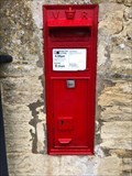
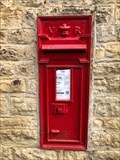
|   Victorian Wall Post Box - Little Barrington, near Burford - Oxfordshire - UK Victorian Wall Post Box - Little Barrington, near Burford - Oxfordshire - UK
in Victorian Post Boxes A Victorian wall post box in Little Barrington near Burford in the county of Oxfordshire, UK. posted by:  ntpayne ntpayne location: West Midlands, United Kingdom date approved: 12/20/2019 last visited: never |
 view gallery view gallery NE7.6 km NE7.6 km
|  St. John the Baptist Cemetery - Burford, Oxfordshire, UK St. John the Baptist Cemetery - Burford, Oxfordshire, UK
in Worldwide Cemeteries Beautiful cemetery located on the grounds of St. John the Baptist Church. posted by: Trail Blaisers location: United Kingdom date approved: 02/18/2013 last visited: 07/06/2010 |
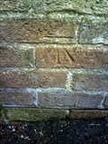
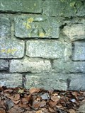
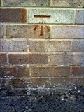
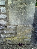
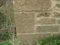 view gallery view galleryN7.7 km |  Cut Marks - River Windrush Tributary Bridge, Great Barrington, Oxfordshire, UK Cut Marks - River Windrush Tributary Bridge, Great Barrington, Oxfordshire, UK
in U.K. and Ireland Trigpoints Two Cut Marks on a bridge over this brook leading to the River Windrush. posted by: Dragontree location: West Midlands, United Kingdom date approved: 03/14/2009 last visited: 02/27/2015 |
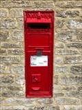 view gallery view galleryNE8.2 km | Victorian Wall Post Box - Widford, near Burford - Oxfordshire - UK in Victorian Post Boxes A Victorian wall post box in Widford near Burford in the county of Oxfordshire, UK. posted by: ntpayne location: West Midlands, United Kingdom date approved: 12/20/2019 last visited: never |
 view gallery view gallery NW9.5 km NW9.5 km
|  Lodge Park - Aldsworth, Nr Cheltenham, Gloucestershire Lodge Park - Aldsworth, Nr Cheltenham, Gloucestershire
in National Trust U.K. The Lodge stands in the Sherborne Estate and has been lovingly restored to its 17th century design. posted by: Dragontree location: West Midlands, United Kingdom date approved: 07/19/2014 last visited: never |
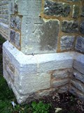
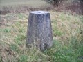
 view gallery view galleryN10.5 km | Triangulation Pillar - Downs Barn, Great Rissington, Gloucestershire in U.K. and Ireland Trigpoints A Trig Point beside a farm track and public footpath near Great Rissington. posted by: Dragontree location: West Midlands, United Kingdom date approved: 03/14/2009 last visited: 02/25/2015 |
 view gallery view galleryNE12.4 km | Victorian Wall Box - Fordwells - Witney - Oxfordshire - UK in Victorian Post Boxes A Victorian wall box in Fordwells near Witney, Oxfordshire, UK. posted by: ntpayne location: West Midlands, United Kingdom date approved: 07/31/2022 last visited: never |
 view gallery view galleryNW13.5 km |  Church of St Peter and St Paul - Northleach - Gloucestershire, UK Church of St Peter and St Paul - Northleach - Gloucestershire, UK
in Medieval Churches Known as the Cathedral of the Cotswolds, this "wool church" dates back at least 800 years on the same site. posted by:  The Pirate King The Pirate King location: South West England, United Kingdom date approved: 04/20/2024 last visited: 04/01/2010 |
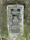
 view gallery view gallery E13.5 km E13.5 km
| Cut Benchmark - #103 Burford Road - Witney - UK in U.K. and Ireland Trigpoints Ordnanace Survey cut mark benchmark described on the Bench Mark Database. posted by: Postells location: Southern England, United Kingdom date approved: 09/04/2011 last visited: never |
 view gallery view galleryE13.5 km | Cut Benchmark - #32 Tower Hill - Witney - UK in U.K. and Ireland Trigpoints Ordnance Survey cut mark benchmark described on the Bench Mark Database. posted by: Postells location: Southern England, United Kingdom date approved: 09/04/2011 last visited: never |
 view gallery view galleryNE13.5 km |  The Shaven Crown, Shipton-Under-Wychwood, Oxon, UK The Shaven Crown, Shipton-Under-Wychwood, Oxon, UK
in Unique Chimneys and Chimney Pots A chimney on the Shaven Crown Inn with gargoyle detail at the top edge. The Shaven Crown is situated in the beautiful village of Shipton-under-Wychwood. posted by: Morn Hyland location: Southern England, United Kingdom date approved: 08/12/2009 last visited: never |
 view gallery view galleryE13.7 km | Cut Benchmark - The Old Chapel - Witney - UK in U.K. and Ireland Trigpoints Ordnance Survey cut mark benchmark discussed on the Bench Mark Database. posted by: Postells location: Southern England, United Kingdom date approved: 09/03/2011 last visited: never |
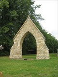 view gallery view galleryE13.7 km |  Witney Arch - Oxon Witney Arch - Oxon
in Freestanding Arches a small arch near a converted church in the historic town of Witney posted by: Norfolk12 location: United Kingdom date approved: 07/24/2009 last visited: 11/07/2010 |
 view gallery view galleryE13.7 km | Cut Benchmark - Tower Hill - Witney - UK in U.K. and Ireland Trigpoints Ordnance Survey cut mark benchmark described on the Bench Mark Database. posted by: Postells location: Southern England, United Kingdom date approved: 09/03/2011 last visited: never |
 view gallery view galleryE13.7 km | Cut Benchmark - #20 Ducklington Lane - Witney - UK in U.K. and Ireland Trigpoints Ordnance Survey cut mark benchmark described on the Bench Mark Database. posted by: Postells location: Southern England, United Kingdom date approved: 09/03/2011 last visited: never |
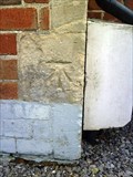 view gallery view galleryE13.8 km | Cut Benchmark - #55 Burford Road - Witney - UK in U.K. and Ireland Trigpoints Ordnance Survey cut mark benchmark described on the Bench Mark Database. posted by: Postells location: Southern England, United Kingdom date approved: 09/04/2011 last visited: never |
 view gallery view galleryE14 km | Cut Benchmark - #193 Moorland Road - Witney - UK in U.K. and Ireland Trigpoints Ordnance Survey cut mark benchmark described on the Bench Mark Database. posted by: Postells location: Southern England, United Kingdom date approved: 09/03/2011 last visited: 03/14/2015 |
 view gallery view galleryNW14 km | Fosse Way in U.K. and Ireland Trigpoints Fosse Way Trigpoint on the A429 near Northleach, Gloucestershire. posted by: theblack location: United Kingdom date approved: 12/09/2007 last visited: 06/07/2015 |
 view gallery view galleryE14.2 km | Cut Benchmark - #122 Corn Street - Witney - UK in U.K. and Ireland Trigpoints Ordnance Survey cut mark benchmark described on the Bench Mark Database. posted by: Postells location: Southern England, United Kingdom date approved: 09/04/2011 last visited: never |
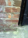 view gallery view galleryE14.2 km | Cut Benchmark - #1 The Springs - Witney - UK in U.K. and Ireland Trigpoints Ordnance Survey cut mark benchmark described on the Bench Mark Database. posted by: Postells location: Southern England, United Kingdom date approved: 09/04/2011 last visited: never |
 view gallery view galleryE14.2 km | Cut Benchmark - #18 The Crofts - Witney - UK in U.K. and Ireland Trigpoints Ordnance Survey cut mark benchmark described on the Bench Mark Database. posted by: Postells location: Southern England, United Kingdom date approved: 09/04/2011 last visited: never |
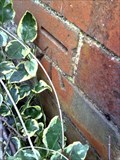
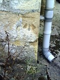
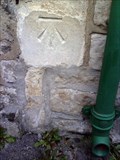
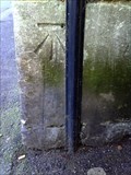
 view gallery view galleryN14.2 km | Cut Benchmark - Hillside House, Little Rissington in U.K. and Ireland Trigpoints Cut Ordnance Survey Benchmark on the wall of a house in Little Rissington. posted by: JamesA60 location: West Midlands, United Kingdom date approved: 07/27/2019 last visited: never |
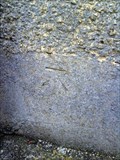 view gallery view galleryE14.3 km | Cut Benchmark - #18 Burford Road - Witney - UK in U.K. and Ireland Trigpoints Ordnance Survey cut mark benchmark described on the Bench Mark Database. posted by: Postells location: Southern England, United Kingdom date approved: 09/04/2011 last visited: never |
 view gallery view galleryE14.3 km | Cut Benchmark - #51 Corn Street - Witney - UK in U.K. and Ireland Trigpoints Ordnance Survey cut mark benchmark described on the Bench Mark Database. posted by: Postells location: Southern England, United Kingdom date approved: 09/04/2011 last visited: never |
 view gallery view galleryE14.3 km | Cut Benchmark - Thames Water Pumping Station - Witney - UK in U.K. and Ireland Trigpoints Survey cut mark benchmark described on the Bench Mark Database. posted by: Postells location: Southern England, United Kingdom date approved: 09/03/2011 last visited: never |
|