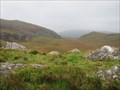
 view gallery view gallery NW25.3 km NW25.3 km
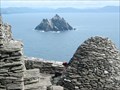
|   Skellig Michael Skellig Michael
in World Heritage Sites A monastic complex located on Skellig Michael, an island 9 miles off County Kerry, Ireland. posted by:  Team KTO'Brien Team KTO'Brien location: Ireland date approved: 09/10/2006 last visited: 07/06/2011 |
 view gallery view gallery N26.6 km N26.6 km
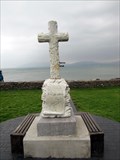
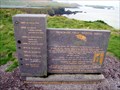
|  T. C. Millerick Memorial - Waterville, County Kerry, Ireland T. C. Millerick Memorial - Waterville, County Kerry, Ireland
in Citizen Memorials Memorial cross for doctor in the town of Waterville, County Kerry, Ireland. posted by:  BruceS BruceS location: Munster, Ireland date approved: 02/06/2011 last visited: 09/06/2016 |
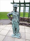 view gallery view galleryN26.7 km |  Charlie Chaplin - Waterville, County Kerry, Ireland Charlie Chaplin - Waterville, County Kerry, Ireland
in Statues of Historic Figures Statue of silent film star Charlie Chaplin in the southwest Ireland community of Waterville. posted by: BruceS location: Munster, Ireland date approved: 02/08/2011 last visited: 09/06/2016 |
 view gallery view gallery NE29.9 km NE29.9 km
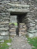
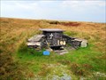
|  Staigue Fort Staigue Fort
in Castles This is a prime example of a 2000 year old castle made entirely of carefully laid stones without mortar. Amazing! posted by: Ama&Papa location: Ireland date approved: 11/15/2005 last visited: 06/16/2006 |
 view gallery view galleryN33.2 km |  FIRST - Trans-Atlantic Telegraph - Valentia Island, County Kerry, Ireland FIRST - Trans-Atlantic Telegraph - Valentia Island, County Kerry, Ireland
in First of its Kind Location of the eastern end of the first trans-Atlantic telegraph on Valentia Island, County Kerry, Ireland. posted by: BruceS location: Munster, Ireland date approved: 02/05/2011 last visited: 07/04/2011 |
 view gallery view galleryN33.2 km |  Telegraph Field Valentia Island - Valentia Island, County Kerry, Ireland Telegraph Field Valentia Island - Valentia Island, County Kerry, Ireland
in Signs of History Marker for location of first trans-Atlantic telegraph cable on Valentia Island, County Kerry, Ireland. posted by: BruceS location: Munster, Ireland date approved: 02/06/2011 last visited: 07/04/2011 |
 view gallery view galleryN35.1 km |  St. Brendan's Well - Valentia Island, County Kerry, Ireland St. Brendan's Well - Valentia Island, County Kerry, Ireland
in Holy Wells Holy well on Valentia Island, County Kerry, Ireland. posted by: BruceS location: Munster, Ireland date approved: 02/06/2011 last visited: 08/27/2014 |
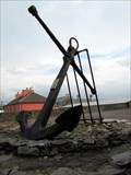 view gallery view galleryN36.2 km |  Crompton Anchor - Knightstown, Valentia Island, County Kerry, Ireland Crompton Anchor - Knightstown, Valentia Island, County Kerry, Ireland
in Anchors Anchor from four-masted sailing ship which had sunk off the coast of Ireland. posted by: BruceS location: Munster, Ireland date approved: 02/05/2011 last visited: never |
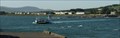 view gallery view galleryN36.5 km |  Valentia Island Car Ferry Valentia Island Car Ferry
in Ferries and Ferry Landings The ferry connects Renard Point and Knightstown. posted by:  me.toString me.toString location: Munster, Ireland date approved: 10/03/2013 last visited: 07/06/2011 |
 view gallery view galleryNE38.3 km | Steve "Crusher" Casey - Sneem, County Kerry, Ireland in Statues of Historic Figures Statue of former world champion professional wrestler in the town of Sneem, County Kerry, Ireland. posted by: BruceS location: Munster, Ireland date approved: 02/08/2011 last visited: 02/20/2013 |
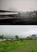 view gallery view galleryN38.5 km |  Cahirciveen Cahirciveen
in Photos Then and Now Cahirciveen on The Ring of Kerry in Ireland posted by: MadPlanet location: Ireland date approved: 01/08/2007 last visited: 07/04/2011 |
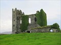 view gallery view galleryN38.9 km |  Ballycarbery Castle - Cahersiveen, County Kerry, Ireland Ballycarbery Castle - Cahersiveen, County Kerry, Ireland
in Wikipedia Entries Ruins of a castle near Cahersiveen, County Kerry, Ireland. posted by: BruceS location: Munster, Ireland date approved: 02/04/2011 last visited: 03/05/2013 |
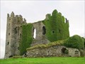 view gallery view galleryN38.9 km | Ballycarbery Castle - Cahersiveen, County Kerry, Ireland in Castles Ruins of a castle near Cahersiveen, County Kerry, Ireland. posted by: BruceS location: Munster, Ireland date approved: 02/05/2011 last visited: 03/05/2013 |
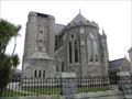 view gallery view galleryN38.9 km |  Daniel O'Connell Memorial Church of the Holy Cross - Cahersiveen, County Kerry, Ireland Daniel O'Connell Memorial Church of the Holy Cross - Cahersiveen, County Kerry, Ireland
in Roman Catholic Churches Catholic church in the town of Cahersiveen along the Ring of Kerry in southwest Ireland. posted by: BruceS location: Munster, Ireland date approved: 02/04/2011 last visited: 07/12/2014 |
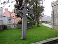 view gallery view galleryN38.9 km |  Daniel O'Connell Memorial Church Cross - Cahersiveen, County Kerry, Ireland Daniel O'Connell Memorial Church Cross - Cahersiveen, County Kerry, Ireland
in Churchyard Crosses Simple Celtic cross on the grounds of the Daniel O'Connell Memorial Church Cross in Cahersiveen, County Kerry, Ireland. posted by: BruceS location: Munster, Ireland date approved: 02/05/2011 last visited: never |
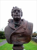 view gallery view galleryN39.6 km | Daniel O'Connell - Caherciveen, County Kerry, Ireland in Statues of Historic Figures Bust of early 19th century Irish political leader referred to as The Liberator or The Emancipator. The sculpture is in Daniel O'Connell Memorial Park which is located across the river from his birth place. posted by: BruceS location: Munster, Ireland date approved: 02/03/2011 last visited: 07/30/2012 |
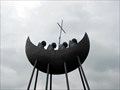 view gallery view galleryN39.6 km |  Skellig Monks - Caherciveen, County Kerry, Ireland Skellig Monks - Caherciveen, County Kerry, Ireland
in Figurative Public Sculpture Sculpture also known as the St. Brendon's Voyage Sculpture is located just east of the town of Caherciveen, County Kerry, Ireland. posted by: BruceS location: Ireland date approved: 02/04/2011 last visited: 06/16/2016 |
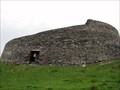 view gallery view galleryN39.8 km |  Cahergall Stone Fort - Cahershiven, County Kerry, Ireland Cahergall Stone Fort - Cahershiven, County Kerry, Ireland
in Historic Forts Historic stone fort near Cahershiven, County Kerry, Ireland. posted by: BruceS location: Munster, Ireland date approved: 02/16/2011 last visited: 07/04/2011 |
 view gallery view gallery SE53.6 km SE53.6 km
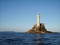
|  fastnet rock lighthouse fastnet rock lighthouse
in Preserved Architectural Remnants and Ruins The current lighthouse is the second to be built on the rock and the highest in Ireland. posted by: apple crumble88 location: Connacht, Ireland date approved: 07/27/2011 last visited: 08/26/2014 |
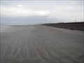 view gallery view galleryNE55.7 km |  Rossbeigh Beach - Glenbeigh, County Kerry, Ireland Rossbeigh Beach - Glenbeigh, County Kerry, Ireland
in Beaches Beach along the Ring of Kerry in County Kerry, Ireland. posted by: BruceS location: Munster, Ireland date approved: 02/13/2011 last visited: 09/06/2016 |
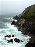
 view gallery view galleryN57.8 km | Slea Head - Ireland in Wikipedia Entries Slea Head (Irish: Ceann Sléibhe) is a promontory in the westernmost part of the Dingle Peninsula. posted by: Noe1 location: Munster, Ireland date approved: 11/04/2014 last visited: never |
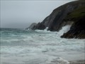
 view gallery view galleryN57.8 km |  Slea Head - Kerry, Ireland Slea Head - Kerry, Ireland
in Wavy Places Slea Head (Irish: Ceann Sléibhe) is a promontory in the westernmost part of the Dingle Peninsula, famous by the dramatic look of waves. posted by: Noe1 location: Munster, Ireland date approved: 11/04/2014 last visited: 04/14/2015 |
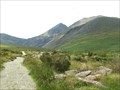
 view gallery view galleryNE58.3 km |  Moll's Gap - County Kerry, Ireland Moll's Gap - County Kerry, Ireland
in Named Mountain Gaps Scenic gap located along the Ring of Kerry. posted by: BruceS location: Munster, Ireland date approved: 02/05/2011 last visited: 04/13/2015 |
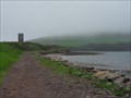 view gallery view galleryN58.4 km |  Irish watch (look-out) tower, Dingle - Ireland Irish watch (look-out) tower, Dingle - Ireland
in Look-Out Towers Irish (former) watch tower over Dingle Bay posted by: superstein location: Leinster, Ireland date approved: 06/20/2019 last visited: never |
 view gallery view galleryNE58.7 km |  Corrán Tuathail - Kerry, Ireland Corrán Tuathail - Kerry, Ireland
in Geographic High Points The highest peak in Ireland. posted by: Noe1 location: Ireland date approved: 11/06/2014 last visited: 06/21/2018 |
|