 view gallery view gallery S2.1 km S2.1 km
|   Becontree Underground Station - Gale Street, Becontree, London, UK Becontree Underground Station - Gale Street, Becontree, London, UK
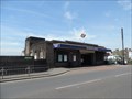
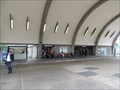
in Wikipedia Entries The entrance hall and ticket office straddle the tracks on the west side of Gale Street. Access is down to the platforms which serve the District Line. posted by:  Master Mariner Master Mariner location: London, United Kingdom date approved: 07/21/2014 last visited: never |
 view gallery view galleryS2.1 km |  Becontree Underground Station - Gale Street, Becontree, London, UK Becontree Underground Station - Gale Street, Becontree, London, UK
in The Underground The entrance hall and ticket office straddle the tracks on the west side of Gale Street. Access is down to the platforms which serve the District Line. posted by: Master Mariner location: London, United Kingdom date approved: 07/20/2014 last visited: never |
 view gallery view galleryS2.1 km |  Becontree Underground Station - Gale Street, Becontree, London, UK Becontree Underground Station - Gale Street, Becontree, London, UK
in Ghosts and Hauntings A faceless ghost is said to haunt Becontree tube station. The station's entrance hall and ticket office straddle the tracks on the west side of Gale Street. Access is down to the platforms which serve the District Line. posted by: Master Mariner location: London, United Kingdom date approved: 07/20/2014 last visited: never |
 view gallery view gallery SE2.1 km SE2.1 km
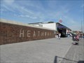
| Dagenham Heathway Underground Station - Heathway, Dagneham, London, UK in Wikipedia Entries Dagenham Heathway tube station serves London Underground's District Line. The station's entrance and ticket hall are situated on the south west side of Heathway and they straddle the tracks with ramps leading down to the platforms. posted by: Master Mariner location: London, United Kingdom date approved: 07/20/2014 last visited: never |
 view gallery view gallerySE2.1 km | Dagenham Heathway Underground Station - Heathway, Dagneham, London, UK in The Underground Dagenham Heathway tube station serves London Underground's District Line. The station's entrance and ticket hall are situated on the south west side of Heathway and they straddle the tracks with ramps leading down to the platforms. posted by: Master Mariner location: London, United Kingdom date approved: 07/20/2014 last visited: never |
 view gallery view gallerySE2.7 km | Dagenham East Underground Station - Rainham Road, Dagenham, London, UK in Wikipedia Entries Dagenham East tube station serves the District Line. The entrance and ticket hall are on the south west side of Rainham Road. Stairs lead down to the platforms from the ticket hall. posted by: Master Mariner location: London, United Kingdom date approved: 07/20/2014 last visited: never |
 view gallery view gallerySE2.7 km | Dagenham East Underground Station - Rainham Road, Dagenham, London, UK in The Underground Dagenham East tube station serves the District Line. The entrance and ticket hall are on the south west side of Rainham Road. Stairs lead down to the platforms from the ticket hall. posted by: Master Mariner location: London, United Kingdom date approved: 07/24/2014 last visited: 10/15/2020 |
 view gallery view gallery E2.9 km E2.9 km
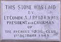
|  1949 - The Avenues Social Club - Dagenham Road, Romford, London, UK 1949 - The Avenues Social Club - Dagenham Road, Romford, London, UK
in Dated Buildings and Cornerstones This 1949 building is on the east side of Dagenham Road in Romford. posted by: Master Mariner location: London, United Kingdom date approved: 09/08/2013 last visited: never |
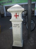 view gallery view galleryE2.9 km |  Coal Tax Post 1 - Dagenham Road, Romford Coal Tax Post 1 - Dagenham Road, Romford
in London Coal Tax Posts This post is located on the west side of Dagenham Road, 80 meters south of Rush Green Road in the Romford area of London. posted by:  Marine Biologist Marine Biologist location: London, United Kingdom date approved: 05/28/2012 last visited: 03/19/2024 |
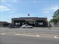
 view gallery view galleryS3.1 km |  Indoor Kart Racing - Rippleside, London, UK Indoor Kart Racing - Rippleside, London, UK
in Satellite Imagery Oddities Capital Karts is an indoor Kart racing circuit that has the longest track in the UK at 1050 metres. It is located to the east of Barking on the southside of the A13 road. posted by: Master Mariner location: London, United Kingdom date approved: 02/15/2016 last visited: never |
 S3.1 km |  Capital Karts, London - The Longest Go Kart Track in the UK Capital Karts, London - The Longest Go Kart Track in the UK
in Racetracks With 1050 metres of professionally designed race track just ready and waiting to be put to the test, Capital Karts easily boast the longest indoor go karting London and the UK has to offer. posted by: NicholasJames location: South East England, United Kingdom date approved: 01/21/2016 last visited: 02/15/2016 |
 view gallery view galleryS3.1 km |  LONGEST - UK Indoor Kart Track - Rippleside, London, UK LONGEST - UK Indoor Kart Track - Rippleside, London, UK
in Superlatives Capital Karts is an indoor Kart racing circuit that has the longest track in the UK at 1050 metres. It is located to the east of Barking on the southside of the A13 road. posted by: Master Mariner location: London, United Kingdom date approved: 02/15/2016 last visited: never |
 view gallery view gallery SW3.2 km SW3.2 km
| Upney Underground Station - Upney Lane, Barking, London, UK in Wikipedia Entries Upney tube station, that serves the District Line, is located on the south west side of Upney Lane in east London. The station's entrance and ticket hall straddle the tracks with ramps leading down to the platforms. posted by: Master Mariner location: London, United Kingdom date approved: 07/21/2014 last visited: never |
 view gallery view gallerySW3.2 km | Upney Underground Station - Upney Lane, Barking, London, UK in The Underground Upney tube station, that serves the District Line, is located on the south west side of Upney Lane in east London. The station's entrance and ticket hall straddle the tracks with ramps leading down to the platforms. posted by: Master Mariner location: London, United Kingdom date approved: 07/20/2014 last visited: never |
 view gallery view gallery NE3.4 km NE3.4 km
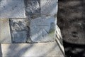
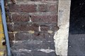
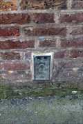
|  Cut Bench Mark - Cotleigh Road, Romford, London, UK Cut Bench Mark - Cotleigh Road, Romford, London, UK
in U.K. and Ireland Trigpoints This mark is cut into a stone wall on the east side of Cotleigh Road. The mark is cut into the northern gatepost of the entrance to St Andrew's Church. posted by: Master Mariner location: London, United Kingdom date approved: 05/02/2017 last visited: never |
 view gallery view galleryNE3.4 km | Cut Bench Mark - St Andrew's Road, Romford, London, UK in U.K. and Ireland Trigpoints This mark is cut into a stone gatepost of St Andrew's church located on the south west side of St Andrew's Road at the junction with Queen Street. The mark is on the south east gatepost on its north west face. posted by: Master Mariner location: London, United Kingdom date approved: 05/02/2017 last visited: never |
 view gallery view galleryNE3.5 km | Cut Bench Mark - Waterloo Road, Romford, London, UK in U.K. and Ireland Trigpoints The mark is cut into brickwork of a wing of a railway bridge on the north east side of Waterloo Road. The mark is on the north west side of the bridge. posted by: Master Mariner location: London, United Kingdom date approved: 05/02/2017 last visited: never |
 view gallery view gallery NW3.5 km NW3.5 km
| Newbury Park Underground Station - Eastern Avenue, Newbury Park, London, UK in Wikipedia Entries Newbury Park is a station on London Underground's Central Line loop in east London. The most noticeable feature of the station is the Grade II listed bus shelter that towers over the approach to the staion's entrance. posted by: Master Mariner location: London, United Kingdom date approved: 07/03/2014 last visited: never |
 view gallery view galleryNW3.5 km | Newbury Park Underground Station - Eastern Avenue, Newbury Park, London, UK in The Underground Newbury Park is a station on London Underground's Central Line loop in east London. The most noticeable feature of the station is the Grade II listed bus shelter that towers over the approach to the staion's entrance. posted by: Master Mariner location: London, United Kingdom date approved: 07/05/2014 last visited: 12/22/2020 |
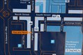
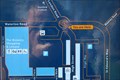 view gallery view galleryNE3.7 km |  You Are Here - Romford High Street, Romford, UK You Are Here - Romford High Street, Romford, UK
in 'You Are Here' Maps This "you are here" map is located on the north west side of Romford High Street at the junction with St Edward's Way. posted by: Master Mariner location: London, United Kingdom date approved: 10/09/2017 last visited: never |
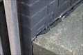
 view gallery view galleryNE3.7 km | Cut Bench Mark - High Street, Romford, London, UK in U.K. and Ireland Trigpoints This mark is cut into the brickwork of a building located on the south east side of the High Street in Romford. The mark is on the north west face of the building at the building's west corner. posted by: Master Mariner location: London, United Kingdom date approved: 05/02/2017 last visited: never |
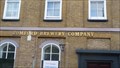 view gallery view galleryNE3.7 km |  Romford Brewery Company (closed) - East London Romford Brewery Company (closed) - East London
in Breweries Ind Coope & Co's old brewery building. posted by: Master Mariner location: London, United Kingdom date approved: 04/29/2011 last visited: 04/17/2021 |
 view gallery view galleryNE3.7 km | Flush Bracket - High Street, Romford, London, UK in U.K. and Ireland Trigpoints The flush bracket is attached a building on the south east side of the High Street in Romford. The bracket is on the north west side of the building close to the entrance to a former brewery. posted by: Master Mariner location: London, United Kingdom date approved: 04/30/2017 last visited: 04/17/2021 |
 view gallery view galleryNE3.9 km | You Are Here - Romford High Street, Romford, UK in 'You Are Here' Maps This "you are here" map is located on the north west side of Romford High Street opposite the former Romford Brewery. posted by: Master Mariner location: London, United Kingdom date approved: 10/09/2017 last visited: never |
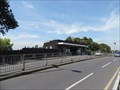
 view gallery view galleryNE3.9 km |  Romford Railway Station - South Street, Romford, UK Romford Railway Station - South Street, Romford, UK
in Train Stations/Depots Romford railway station handles services operated by London Overground and Greater Anglia. The station entrance is located beneath a rail bridge and is on the south west side of South Street in Romford. posted by: Master Mariner location: London, United Kingdom date approved: 10/09/2017 last visited: 04/06/2021 |
|