 view gallery view gallery NE0 km NE0 km
|   Marktplatz, Stadt Werl - NRW, Germany Marktplatz, Stadt Werl - NRW, Germany
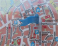
in 'You Are Here' Maps [DE]eine Karte mit dem eigenen Standort am Marktplatz in Werl [ENG] a map with the own location at the market in Werl posted by:  EDTA EDTA location: Nordrhein-Westfalen, Germany date approved: 02/25/2018 last visited: never |
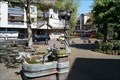
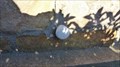
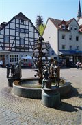 view gallery view galleryNE0 km |  Brunnen an der Basilika Werl - NRW, Germany Brunnen an der Basilika Werl - NRW, Germany
in Fountains [DE] Brunnen mit Bronzefiguren am Marktplatz in Werl
[ENG] Fountain with bronze figures at the market place in Werl posted by: EDTA location: Nordrhein-Westfalen, Germany date approved: 05/12/2016 last visited: never |
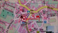
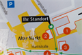 view gallery view galleryNE0 km | Sehenswürdigkeiten der Stadt Werl - NRW, Germany in 'You Are Here' Maps [DE]eine Karte mit dem eigenen Standort in der Fußgängerzone nahe der Basilika in Werl
[ENG] a map with the own location in the pedestrian zone near the Basilica in Werl posted by: EDTA location: Nordrhein-Westfalen, Germany date approved: 05/11/2016 last visited: never |
 view gallery view gallery N0.2 km N0.2 km
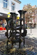
| Brunnen "Salinenplastik" in Werl - NRW, Germany in Fountains [DE] Brunnen mit Solewasser in der Fußgängerzone in Werl
[GER] Fountain with salt water in the pedestrian zone in Werl posted by: EDTA location: Nordrhein-Westfalen, Germany date approved: 05/11/2016 last visited: never |
 view gallery view gallery SE6.1 km SE6.1 km
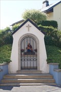
|  Heiligenhäuschen Gröchte, NRW, Germany Heiligenhäuschen Gröchte, NRW, Germany
in Waychapels [DE] Das Heiligenhäuschen wurde 1960 erbaut und von Pfarrer Hayn eingeweiht.
[ENG] The waychapel was built and inaugurated by Rev. Hayn in 1960. posted by: EDTA location: Nordrhein-Westfalen, Germany date approved: 08/24/2015 last visited: 05/15/2015 |
 view gallery view gallerySE6.3 km | Bremer Stadtmusikanten in Fountains [DE] Bronzebrunnen Die Bremer Stadtmusikanten, seit 1984 in Ense (Bremen-Ense) vor dem Rathaus
[ENG] Bronze fountain The Bremen Town Musicians , since 1984 in Ense ( Bremen - Ense ) outside the town hall posted by: EDTA location: Nordrhein-Westfalen, Germany date approved: 05/17/2015 last visited: 05/15/2015 |
 view gallery view gallerySE6.3 km | Karte der Gemeinde Ense, NRW, Germany in 'You Are Here' Maps [DE] Eine Karte mit dem eigenen Standort in der Nähe des Rathauses in Ense.
[ENG] A card with your own position near the town hall of Ense. posted by: EDTA location: Nordrhein-Westfalen, Germany date approved: 09/05/2015 last visited: 09/04/2015 |
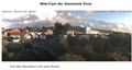 view gallery view gallerySE6.4 km |  Webcam Ense, Ense-Bremen, NRW, Germany Webcam Ense, Ense-Bremen, NRW, Germany
in Web Cameras [DE] Dies ist eine Webcam in der Gemeinde Ense.
[ENG] This is a webcam in the municipality of Ense. posted by: EDTA location: Nordrhein-Westfalen, Germany date approved: 09/04/2015 last visited: never |
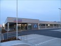 view gallery view gallerySE6.6 km |  ALDI MARKT Werler Straße, Ense-Bremen ALDI MARKT Werler Straße, Ense-Bremen
in ALDI Stores Öffnungszeiten: Montag bis Samstag 08:00-20:00 Uhr So geschlossen posted by: Sebi Neumi location: Nordrhein-Westfalen, Germany date approved: 04/03/2016 last visited: 12/26/2016 |
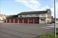 view gallery view gallery SW6.9 km SW6.9 km
|  Freiwillige Feuerwehr Wickede (Ruhr) Freiwillige Feuerwehr Wickede (Ruhr)
in Firehouses Das Gerätehaus des Löschzug 1 der Freiwilligen Feuerwehr Wickede posted by: 4Blackbirds location: Nordrhein-Westfalen, Germany date approved: 06/28/2015 last visited: 08/05/2023 |
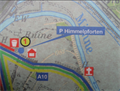 view gallery view gallerySE9.3 km | Naturpark Arnsberger Wald, Parkplatz "Himmelpforten" - NRW, Germany in 'You Are Here' Maps [DE] eine Karte mit dem eigenen Standort am Parplatz nahe der Klosterruine "Himmelpforten" [ENG] a map with the own location in the parking lot near the monastery ruins "Himmelpforten" posted by: EDTA location: Nordrhein-Westfalen, Germany date approved: 03/27/2016 last visited: 03/27/2016 |
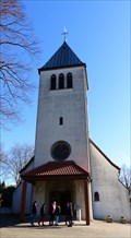 view gallery view gallerySW10.6 km |  Christkönig (Warmen) - Fröndenberg, Germany Christkönig (Warmen) - Fröndenberg, Germany
in Wikipedia Entries Impressive church at L 673 posted by: g300td location: Nordrhein-Westfalen, Germany date approved: 03/18/2015 last visited: never |
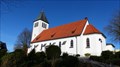 view gallery view gallerySW10.6 km |  Kath. Kirche Christkönig (Warmen) - Fröndenberg, Germany Kath. Kirche Christkönig (Warmen) - Fröndenberg, Germany
in Roman Catholic Churches Impressive church at L 673 posted by: g300td location: Nordrhein-Westfalen, Germany date approved: 03/17/2015 last visited: never |
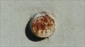 view gallery view gallerySW10.6 km |  NivP-Bolzen Christkönig (Warmen) - Fröndenberg, Germany NivP-Bolzen Christkönig (Warmen) - Fröndenberg, Germany
in German Benchmarks NivP-Bolzen at Christkönig church in Fröndenberg-Frohnhausen. posted by: g300td location: Nordrhein-Westfalen, Germany date approved: 03/17/2015 last visited: never |
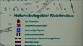 view gallery view gallerySW11.1 km | Naturschutzgebiet Kiebitzwiese - Fröndenberg, Germany in 'You Are Here' Maps Kiebitzwiese in Fröndenberg is a natural reserve since 2002. posted by: g300td location: Nordrhein-Westfalen, Germany date approved: 03/18/2015 last visited: 08/10/2013 |
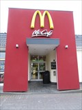
 view gallery view gallery S11.3 km S11.3 km
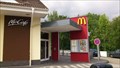
|  Mc Donalds, Werler Strasse, Arnsberg, Germany Mc Donalds, Werler Strasse, Arnsberg, Germany
in McDonald's Restaurants McDonald's Restaurant
Werler Str. 6
59755 Arnsberg posted by: Sebi Neumi location: Nordrhein-Westfalen, Germany date approved: 09/05/2015 last visited: 09/04/2015 |
 view gallery view gallerySW11.6 km | HP-Bolzen Herz Jesu Kirche - Fröndenberg, Germany in German Benchmarks HP-Bolzen an der südlichen Ecke der Kirche.
HP-Stud at the southern corner of the church. posted by: g300td location: Nordrhein-Westfalen, Germany date approved: 03/15/2015 last visited: never |
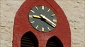 view gallery view gallerySW11.6 km |  Clock of the Herz Jesu Kirche Hohenheide - Fröndenberg, Germany Clock of the Herz Jesu Kirche Hohenheide - Fröndenberg, Germany
in Town Clocks A beautiful clock at the bell tower of Herz Jesu Kirche posted by: g300td location: Nordrhein-Westfalen, Germany date approved: 03/16/2015 last visited: never |
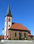 view gallery view gallerySW11.6 km | Herz-Jesu Kirche Hohenheide - Fröndenberg, Germany in Roman Catholic Churches Beautiful church in Fröndenberg/Hohenheide posted by: g300td location: Nordrhein-Westfalen, Germany date approved: 03/15/2015 last visited: never |
 view gallery view galleryS11.6 km |  Der Glockenstuhl, Neheim, NRW, Germany Der Glockenstuhl, Neheim, NRW, Germany
in Carillon [DE] Das Glockenspiel war ein Geschenk der Schützenbruderschaft an die Stadt und die Bürger.
[ENG] The carillon was a gift of Schutterij to the city and the citizens. posted by: EDTA location: Nordrhein-Westfalen, Germany date approved: 09/04/2015 last visited: 01/06/2018 |
 view gallery view gallery E12.1 km E12.1 km
| Mc Donalds, Werler Landstraße, Soest, Germany in McDonald's Restaurants McDonald's Werler Landstraße 4 59494 Soest posted by: Sebi Neumi location: Nordrhein-Westfalen, Germany date approved: 05/30/2016 last visited: never |
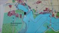 view gallery view gallerySE12.1 km | Karte an der Möhnetalsperre, Möhnesee, NRW, Germany in 'You Are Here' Maps [DE] Eine Karte mit dem eigenen Standort am Südende der Sperrmauer am Möhnesee. [ENG] A map with your own position near the southern end of the water dam of Möhnesee. posted by: EDTA location: Nordrhein-Westfalen, Germany date approved: 09/29/2015 last visited: 09/10/2015 |
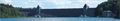 view gallery view gallerySE12.2 km |  Möhnetalsperre - Möhnesee, NRW/Germany Möhnetalsperre - Möhnesee, NRW/Germany
in Water Dams [DE] Bei seiner Fertigstellung war die 650 m lange Möhnetalsperre die größte Stauanlage in Europa.
[ENG] When completed, the 650 m long dam was the largest storage plant in Europe. posted by: EDTA location: Nordrhein-Westfalen, Germany date approved: 09/19/2015 last visited: 08/05/2023 |
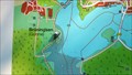 view gallery view gallerySE12.7 km | Karte am Hevearm, Möhnesee, NRW, Germany in 'You Are Here' Maps [DE] Eine Karte mit dem eigenen Standort am Wanderweg am Hevearm. [ENG] A map with your own position at the trail around the "Hevearm" of Möhnesee. posted by: EDTA location: Nordrhein-Westfalen, Germany date approved: 09/29/2015 last visited: 09/10/2015 |
 view gallery view gallery W13 km W13 km
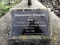
|  N 51° 32.289' E 007° 43.652' - Unna, Germany N 51° 32.289' E 007° 43.652' - Unna, Germany
in Permanent Geographic Coordinates [DE] Diese Koordinaten markieren den geographischen Mittelpunkt von Unna / [EN] The coordinates mark the geographic center of the city of Unna posted by: DerSchnelleLinus location: Nordrhein-Westfalen, Germany date approved: 03/17/2014 last visited: 12/19/2019 |
|