 view gallery view gallery SW0 km SW0 km
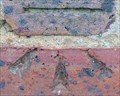
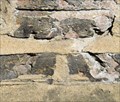
|   Cut Bench Mark - Gunmakers Lane, London, UK Cut Bench Mark - Gunmakers Lane, London, UK
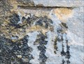
in U.K. and Ireland Trigpoints This mark is cut into a stone section of the parapet of a bridge that crosses the Hertford Union Canal. The mark is on the north east side of the bridge at the south east side of the canal. posted by:  Master Mariner Master Mariner location: London, United Kingdom date approved: 08/16/2015 last visited: never |
 view gallery view gallery NW0 km NW0 km
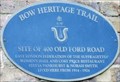
|  Three Colts Bridge - Gunmaker's Lane, London, UK Three Colts Bridge - Gunmaker's Lane, London, UK
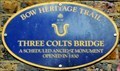
in UK Historical Markers A blue plaque, part of the Bow Heritage Trail, indicates that Three Colts Bridge "opened in 1830". The bridge spans the Hertford Grand Union Canal and joins Gunmaker's Lane with Victoria Park. The plaque is adjacent to the tow path on the north side. posted by: Master Mariner location: London, United Kingdom date approved: 08/18/2018 last visited: never |
 view gallery view gallery S0 km S0 km
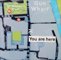
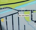
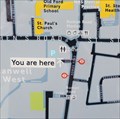
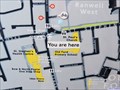
|  You Are Here - Gunmaker's Lane, London, UK You Are Here - Gunmaker's Lane, London, UK
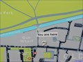
in 'You Are Here' Maps This "you are here" map is on the south west side of Gunmaker's Lane just south of Three Colts Bridge, that spans the Hertford Union Canal, and the Gunmaker's Gate entrance to Victoria Park. posted by: Master Mariner location: London, United Kingdom date approved: 08/18/2015 last visited: never |
 view gallery view gallery N0 km N0 km
| You Are Here - Victoria Park, London, UK in 'You Are Here' Maps The park entrance where this map is located is called "Gunmaker's Gate". It is located on the south east side of the east part of Victoria Park and gives access to the park from Gunmaker's Lane and the Hertford Union Canal towpath. posted by: Master Mariner location: London, United Kingdom date approved: 08/17/2015 last visited: never |
 view gallery view gallery SE0.2 km SE0.2 km
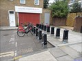
|  Old Ford - Gunmakers Lane, London, UK Old Ford - Gunmakers Lane, London, UK
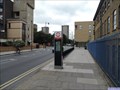
in Bicycle Rentals A docking station for Santander Cycles (new sponsors from February 2015). This docking station is on the north west side of Old Ford Road at the junction with Gunmakers Lane after which the docking station is named. posted by: Master Mariner location: London, United Kingdom date approved: 09/09/2015 last visited: never |
 view gallery view gallerySE0.2 km | You Are Here - Old Ford Road, London, UK in 'You Are Here' Maps This "you are here" map is at a docking station for Santander Cycles (new sponsors from February 2015). This docking station is on the north west side of Old Ford Road at the junction with Gunmakers Lane after which the docking station is named. posted by: Master Mariner location: London, United Kingdom date approved: 09/09/2015 last visited: never |
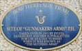 view gallery view gallerySE0.2 km |  Gunmakers Arms Public House - Old Ford Road, London, UK Gunmakers Arms Public House - Old Ford Road, London, UK
in Blue Plaques This Bow Heritage Trail blue plaque is attached to a block of flats on the south east side of Old Ford Road in east London. The plaque indicates the site of the "Gunmakers Arms" public house that was taken over in 1915 for ause as a day nursery. posted by: Master Mariner location: London, United Kingdom date approved: 09/12/2015 last visited: never |
 view gallery view gallerySE0.2 km | Cut Bench Mark - Old Ford Road, London, UK in U.K. and Ireland Trigpoints This mark is cut into a brick post on the south east side of Old Ford Road in east London. posted by: Master Mariner location: London, United Kingdom date approved: 09/08/2015 last visited: never |
 view gallery view gallerySW0.2 km | 400 Old Ford Road - Old Ford Road, London, UK in Blue Plaques This Bow Heritage Trail blue plaque is attached to the south west facing wall of the Lord Morpeth public house on the south east side of Old Ford Road. It marks the site of number 400 that was a building used by the East London Suffragettes. posted by: Master Mariner location: London, United Kingdom date approved: 09/12/2015 last visited: never |
 view gallery view gallerySW0.2 km | Cut Bench Mark - Old Ford Road, London, UK in U.K. and Ireland Trigpoints This mark is cut into the brickwork of a long, high wall on the north west side of Old Ford Road. The mark is cut immediately above the concrete base of the wall at a point where there is a join in the wall. posted by: Master Mariner location: London, United Kingdom date approved: 08/16/2015 last visited: never |
 view gallery view gallerySW0.3 km | Old Ford - Driffield Road, London, UK in Bicycle Rentals A docking station for Santander Cycles (new sponsors from February 2015). This docking station is at the northern end of Driffield Road at the junction with Old Ford Road. posted by: Master Mariner location: London, United Kingdom date approved: 08/16/2015 last visited: never |
 view gallery view gallerySW0.3 km | You Are Here - Driffield Road, London, UK in 'You Are Here' Maps This "you are here" map is at a docking station for Santander Cycles (new sponsors from February 2015). This docking station is at the northern end of Driffield Road at the junction with Old Ford Road. posted by: Master Mariner location: London, United Kingdom date approved: 08/16/2015 last visited: never |
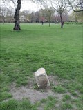 view gallery view gallery W0.3 km W0.3 km
|  St John at Hackney Parish Boundary Marker - Victoria Park, London, UK St John at Hackney Parish Boundary Marker - Victoria Park, London, UK
in Public Land Survey Marks A parish boundary marker stone standing in a grassy area within Victoria Park. posted by:  OrientGeo OrientGeo location: London, United Kingdom date approved: 04/19/2021 last visited: 04/20/2021 |
 view gallery view galleryS0.3 km | Old Ford - Ford Road, London, UK in Bicycle Rentals A docking station for Santander Cycles (new sponsors from February 2015). This docking station is at the north west end of Ford Road - a cul-de-sac. The road is just used to access a car park. posted by: Master Mariner location: London, United Kingdom date approved: 09/09/2015 last visited: never |
 view gallery view galleryS0.3 km | You Are Here - Ford Road, London, UK in 'You Are Here' Maps This "you are here" map is at a docking station for Santander Cycles (new sponsors from February 2015). This docking station is at the north west end of Ford Road - a cul-de-sac. The road is just used to access a car park. posted by: Master Mariner location: London, United Kingdom date approved: 09/09/2015 last visited: never |
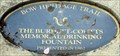 view gallery view galleryW0.3 km | Burdett-Coutts Memorial Drinking Fountain - Victoria Park, London, UK in Blue Plaques This blue plaque for Burdett-Coutts Memorial Drinking Fountain is part of the Bow Heritage Trail in east London. The plaque is attached to a concrete block that is set into the ground in a flower bed close to the fountain in the centre of the park. posted by: Master Mariner location: London, United Kingdom date approved: 08/14/2015 last visited: 04/11/2021 |
 view gallery view gallery NE0.5 km NE0.5 km
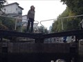
|  Hertford Union Canal – Lock 1 – Hertford Union Top Lock – Old Ford, UK Hertford Union Canal – Lock 1 – Hertford Union Top Lock – Old Ford, UK
in Waterway Locks, Planes and Lifts This is lock 1 on the Hertford Union canal. posted by: ntpayne location: London, United Kingdom date approved: 05/15/2017 last visited: 01/21/2021 |
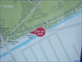
 view gallery view galleryNE0.5 km | You Are Here - Parnell Road, London, UK in 'You Are Here' Maps This "you are here" map is on the north east side of Parnell Road at the junction with Jodrell Road. It is close to the Lock House Gate entrance to Victoria Park and the Hertford Union Canal. posted by: Master Mariner location: London, United Kingdom date approved: 08/18/2015 last visited: never |
 view gallery view galleryS0.5 km | You Are Here - Roman Road, London, UK in 'You Are Here' Maps This "you are here" map is located on the north west side of Roman Road at the junction with St Stephen's Road. This is the south west start of Roman Road Market. posted by: Master Mariner location: London, United Kingdom date approved: 09/09/2015 last visited: never |
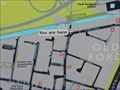
 view gallery view gallerySW0.5 km | You Are Here - Victoria Park, London, UK in 'You Are Here' Maps The park entrance where this map is located is called "Terrace Gate". It is located on the south east side of the east part of Victoria Park and provides access to the park from Old Ford Road. posted by: Master Mariner location: London, United Kingdom date approved: 08/15/2015 last visited: never |
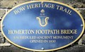 view gallery view galleryNE0.5 km | Homerton Footpath Bridge - Parnell Road, London, UK in Blue Plaques This blue plaque for Sthe Homerton Footpath Bridge is part of the Bow Heritage Trail in east London. It is attached to a wall on the north side of the bridge that spans the Hertford Union Canal. The path leads to/from Victoria Park. posted by: Master Mariner location: London, United Kingdom date approved: 08/17/2015 last visited: 01/21/2021 |
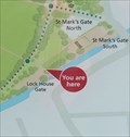 view gallery view galleryNE0.5 km | You Are Here - Victoria Park, London, UK in 'You Are Here' Maps The park entrance where this map is located is called "Lock House Gate". It is located on the south east side of the east part of Victoria Park and gives access to the park from Parnell Road and the Hertford Union Canal towpath. posted by: Master Mariner location: London, United Kingdom date approved: 08/17/2015 last visited: never |
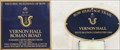 view gallery view gallerySE0.5 km | Vernon Hall - Roman Road, London, UK in Blue Plaques Vernon Hall was built as the Bow Library with most of the cost paid by the Vitorian philanthropist Passmore Edwards. It stands on the south east side of Roman Road and is graced with two blue plaques. posted by: Master Mariner location: London, United Kingdom date approved: 09/11/2015 last visited: never |
 view gallery view gallery E0.5 km E0.5 km
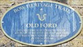
| Old Ford - Old Ford Road, London, UK in UK Historical Markers This Bow Heritage Trail blue plaque is attached to a building on the north side of Old Ford Road at the junction with Parnell Road in east London. posted by: Master Mariner location: London, United Kingdom date approved: 02/23/2017 last visited: 01/21/2021 |
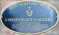 view gallery view gallerySW0.5 km | Chisenhale Gallery - Chisenhale Road, London, UK in Blue Plaques This Bow Heritage Trail blue plaque is attached to the south east face of the Chisenhale Gallery in Chisenhale Road in east London. Before becoming a gallery, the building was used as a veneer factory and created Spitfire propellers during WWII. posted by: Master Mariner location: London, United Kingdom date approved: 09/12/2015 last visited: never |
|