 view gallery view gallery NW2.3 km NW2.3 km
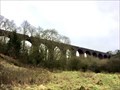
|   Huckford Viaduct - Winterbourne Down. United Kingdom. Huckford Viaduct - Winterbourne Down. United Kingdom.
in Stone Bridges A very impressive 11 arch viaduct. posted by:  BRISTOLIAN BRISTOLIAN location: South West England, United Kingdom date approved: 04/21/2021 last visited: never |
 view gallery view gallery SW3.2 km SW3.2 km
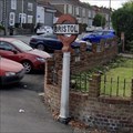
|  Bristol & Gloucestershire boundary sign. Bristol & Gloucestershire boundary sign.
in Border Crossings A precast concrete listed Bristol sign. Indicating the boundary of Bristol and South Gloucestershire. posted by: BRISTOLIAN location: South West England, United Kingdom date approved: 03/31/2021 last visited: 04/03/2021 |
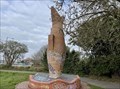 view gallery view gallerySW4.2 km |  Fish on its Nose - Fishponds, Bristol Fish on its Nose - Fishponds, Bristol
in Figurative Public Sculpture On the site of old Fishponds Station, a brick fish diving into a pond. A time capsule collected by local children is even concreted in its belly. posted by: BRISTOLIAN location: South West England, United Kingdom date approved: 04/13/2021 last visited: never |
 view gallery view gallery W4.8 km W4.8 km
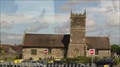
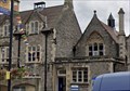
|  St. Michael's Church -- Stoke Gifford, Gloucestershire, UK St. Michael's Church -- Stoke Gifford, Gloucestershire, UK
in Medieval Churches A medieval church dating from the 14th century stands near the railroad tracks in Stoke Gifford, near Bristol posted by: Benchmark Blasterz location: South West England, United Kingdom date approved: 08/24/2016 last visited: 09/13/2014 |
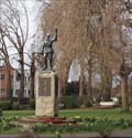 view gallery view gallerySW5 km |  World War 1 Memorial - Fishponds, Bristol. UK World War 1 Memorial - Fishponds, Bristol. UK
in World War I Memorials and Monuments A World War 1 memorial statue dedicated to the fallen. posted by: BRISTOLIAN location: South West England, United Kingdom date approved: 04/23/2021 last visited: never |
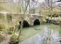 view gallery view galleryW5.1 km |  Wickham Bridge: Stapleton, Bristol. Wickham Bridge: Stapleton, Bristol.
in Arch Bridges Wickham Bridge is a medieval bridge and is recorded as the oldest bridge in Bristol. posted by: BRISTOLIAN location: South West England, United Kingdom date approved: 04/14/2021 last visited: never |
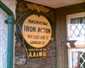 view gallery view gallery N5.8 km N5.8 km
|  Iron Acton Iron Acton
in Automobile Association Signs On the White Hart Inn, Iron Acton, South Gloucestershire posted by: Chaotica_UK location: Southern England, United Kingdom date approved: 01/29/2006 last visited: 06/13/2021 |
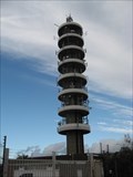 view gallery view galleryW6 km |  Purdown BT Tower. Bristol Purdown BT Tower. Bristol
in Satellite Imagery Oddities An imposing tower over the Bristol skyline. posted by: BRISTOLIAN location: South West England, United Kingdom date approved: 04/05/2021 last visited: never |
 view gallery view gallerySW6 km |  Antonio Williams-Easton, Bristol, England Antonio Williams-Easton, Bristol, England
in Medal Of Honor Resting Places Peacetime Medal of Honor Recipient for action on the USS Huron on November 24, 1877. He is buried in Greenbank Cemetery, Easton Bristol Unitary Authority, Bristol, England. posted by:  Don.Morfe Don.Morfe location: South West England, United Kingdom date approved: 01/03/2018 last visited: 12/18/2021 |
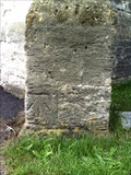
 view gallery view gallery NE6 km NE6 km
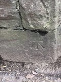
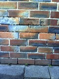
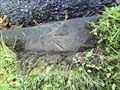
|  Cut mark - Railway bridge, North Road, Yate, S Gloucestershire Cut mark - Railway bridge, North Road, Yate, S Gloucestershire
in U.K. and Ireland Trigpoints Benchmark posted by: The Spanners location: Southern England, United Kingdom date approved: 02/12/2021 last visited: 03/12/2017 |
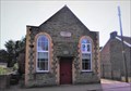
 view gallery view galleryNE6.1 km | Cut benchmark - YMCA hall, Yate, S Glos in U.K. and Ireland Trigpoints Benchmark posted by: The Spanners location: Southern England, United Kingdom date approved: 02/09/2021 last visited: 03/12/2017 |
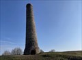 view gallery view gallerySW6.1 km |  Lonely Chimney - Trooper’s Hill. Bristol UK Lonely Chimney - Trooper’s Hill. Bristol UK
in Lonely Chimneys A long brick built chimney on Tropper’s Hill. Situated in the Kingswood area of Bristol. It’s height was recently measured at 52’3”. posted by: BRISTOLIAN location: South West England, United Kingdom date approved: 04/19/2021 last visited: never |
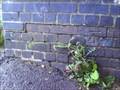
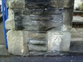
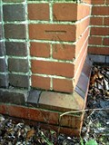
 view gallery view galleryNE6.8 km | Cut bench mark - Baptist Chapel, North Road, Yate, S Gloucestershire in U.K. and Ireland Trigpoints Cut benchmark on Engine Common Baptist Chapel, located at lower RH of front face. posted by: The Spanners location: Southern England, United Kingdom date approved: 02/13/2021 last visited: 04/23/2017 |
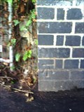
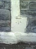
 view gallery view galleryW7.1 km | Cut Benchmark - Horfield Congregational Church - Bristol in U.K. and Ireland Trigpoints Ordnance Survey cut mark benchmark on part of the church set back behind the main hall and described on the Bench Mark Database. posted by: Postells location: Southern England, United Kingdom date approved: 08/30/2011 last visited: 05/30/2016 |
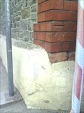
 view gallery view galleryW7.1 km | Cut Benchmark - Ashley Down Road - Bristol in U.K. and Ireland Trigpoints Cut mark on 4/5th bricks above path which runs from Station Road to Station Lane, and about 30" from west end of bridge wall. posted by: Postells location: Southern England, United Kingdom date approved: 08/30/2011 last visited: 05/30/2016 |
 view gallery view galleryNE7.2 km | Cut Benchmark - High Street, Chipping Sodbury, S Gloucestershire in U.K. and Ireland Trigpoints Benchmark posted by: The Spanners location: Southern England, United Kingdom date approved: 02/13/2021 last visited: 03/25/2021 |
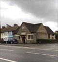
 view gallery view galleryW7.2 km |  The Farm The Farm
in Pubs and Inns A Great Pub with a very funny painting on the wall. posted by: PLnauta location: South West England, United Kingdom date approved: 06/03/2010 last visited: 06/06/2021 |
 view gallery view gallerySW7.4 km | Cut Benchmark - Mina Road - Bristol in U.K. and Ireland Trigpoints Dusk photograph of Ordnance Survey cut mark benchmark which is described on the Bench Mark Database. posted by: Postells location: Southern England, United Kingdom date approved: 08/30/2011 last visited: 08/24/2017 |
 view gallery view gallerySW7.4 km |  Bristol Climbing Center Bristol Climbing Center
in Artificial Climbing Walls A great climbing center, build inside an old church. Here you climb to heaven :) posted by: PLnauta location: South West England, United Kingdom date approved: 06/14/2010 last visited: 06/06/2021 |
 view gallery view galleryW7.4 km | Cut Benchmark - kerbstone of Kellaway Avenue - Bristol in U.K. and Ireland Trigpoints Ordnance Survey 1956 rivet benchmark which is described on the Bench Mark Database. posted by: Postells location: Southern England, United Kingdom date approved: 08/31/2011 last visited: 05/30/2016 |
 view gallery view galleryW7.4 km | Cut Benchmark - Seymour Road at junction with Ashley Down Road - Bristol in U.K. and Ireland Trigpoints Cut mark on corner stone of S angle (back) above pavement of Seymour Road, although the #95 refers to Ashley Down Road and is Ashley Fish Bar. posted by: Postells location: Southern England, United Kingdom date approved: 08/30/2011 last visited: 12/31/2017 |
 view gallery view galleryW7.6 km | Cut Benchmark - Ashley Hall - Bristol in U.K. and Ireland Trigpoints Extensive building work is in progress as the Hall is converted to flats. The Ordnance Survey cut mark benchmark, which is surviving between the scaffolding poles, is described on the Bench Mark Database. posted by: Postells location: Southern England, United Kingdom date approved: 08/30/2011 last visited: 12/31/2017 |
 view gallery view galleryW7.6 km | Cut Benchmark - Church Road - Bristol in U.K. and Ireland Trigpoints Ordnance Survey cut mark benchmark described on the Bench Mark Database. posted by: Postells location: Southern England, United Kingdom date approved: 08/30/2011 last visited: 05/30/2016 |
 view gallery view galleryW7.7 km | Cut Benchmark - Kellaway Avenue - Bristol in U.K. and Ireland Trigpoints Ordnance Survey 1GL Bolt benchmark which was cut in 1849 as one of the marks on the survey line from Gloucester to London and which is described on the Bench Mark Database. posted by: Postells location: Southern England, United Kingdom date approved: 08/31/2011 last visited: 05/30/2016 |
 view gallery view galleryW7.7 km | Cut Benchmark - Wellington Hill - Bristol in U.K. and Ireland Trigpoints Ordnance Survey cut mark benchmark described on the Bench Mark Database. posted by: Postells location: Southern England, United Kingdom date approved: 08/31/2011 last visited: 05/30/2016 |
|