 view gallery view gallery SW0.3 km SW0.3 km
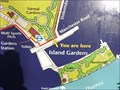
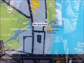
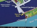
|   You Are Here - Millwall Park, Manchester Road, Isle of Dogs, London, UK You Are Here - Millwall Park, Manchester Road, Isle of Dogs, London, UK
in 'You Are Here' Maps This map is at the southern entrance to Millwall Park, a large open playing field at the southern end of the Isle of Dogs. Island Gardens DLR stations is close by. posted by:  Master Mariner Master Mariner location: London, United Kingdom date approved: 02/03/2013 last visited: 07/14/2015 |
 view gallery view gallery W0.3 km W0.3 km
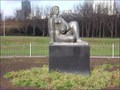
|  Woman and Fish - Millwall Park, Isle of Dogs, London, UK Woman and Fish - Millwall Park, Isle of Dogs, London, UK
in Figurative Public Sculpture This larger than life statue is located in Millwall Park towards the southern end of the Isle of Dogs in east London. It is a replica of a sculpture that was vandalised and subsequently scrapped. posted by: Master Mariner location: London, United Kingdom date approved: 02/03/2013 last visited: 07/14/2015 |
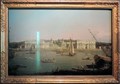 view gallery view gallerySW0.3 km |  Greenwich Hospital from the north bank of the Thames - Island Gardens, London, UK Greenwich Hospital from the north bank of the Thames - Island Gardens, London, UK
in Paintings Then and Now The view, in the Canaletto painting, was created looking south from the southern end of the Isle of Dogs. Canaletto has framed the Queen's House between the buildings of the Greenwich Hospital that is now known as the Old Royal Naval College. posted by: Master Mariner location: London, United Kingdom date approved: 01/28/2015 last visited: 07/24/2014 |
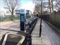 view gallery view gallerySW0.3 km |  Cubitt Town - Saunders Ness Road, Isle of Dogs, London, UK Cubitt Town - Saunders Ness Road, Isle of Dogs, London, UK
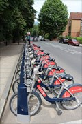
in Bicycle Rentals A docking station for "Boris Bikes", more properly known as Barclay Bikes. This docking station is Saunders Ness Road that runs parallel to Island Gardens park that fronts the River Thames. posted by: Master Mariner location: London, United Kingdom date approved: 02/03/2013 last visited: 06/09/2014 |
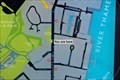
 view gallery view gallerySW0.3 km | You Are Here - Saunders Ness Road, Isle of Dogs, London, UK in 'You Are Here' Maps This map is found on a docking station for "Boris Bikes", more properly known as Barclay Bikes. This docking station is Saunders Ness Road that runs parallel to Island Gardens park that fronts the River Thames. posted by: Master Mariner location: London, United Kingdom date approved: 02/03/2013 last visited: 06/09/2014 |
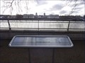 view gallery view gallerySW0.3 km |  Island Gardens Orientation Table - Saunders Ness Road, Isle of Dogs, London, UK Island Gardens Orientation Table - Saunders Ness Road, Isle of Dogs, London, UK
in Orientation Tables This orientation is to be found in the Island Gardens park at the southern end of the Isle of Dogs in east London. posted by: Master Mariner location: London, United Kingdom date approved: 02/03/2013 last visited: never |
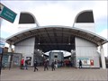 view gallery view gallerySW0.3 km |  Island Gardens DLR Station - Manchester Road, Isle of Dogs, London, UK Island Gardens DLR Station - Manchester Road, Isle of Dogs, London, UK
in Wikipedia Entries Island gardens DLR station is at the southern end of the Isle of Dogs and is the last station before the tracks pass under the River Thames from the north to south side of the river. posted by: Master Mariner location: London, United Kingdom date approved: 02/02/2013 last visited: 11/04/2021 |
 view gallery view gallerySW0.3 km |  Island Gardens DLR Station - Manchester Road, Isle of Dogs, London, UK Island Gardens DLR Station - Manchester Road, Isle of Dogs, London, UK
in The Underground Island gardens DLR station is at the southern end of the Isle of Dogs and is the last station before the tracks pass under the River Thames from the north to south side of the river. posted by: Master Mariner location: London, United Kingdom date approved: 02/02/2013 last visited: 01/25/2021 |
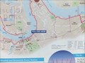
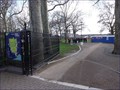 view gallery view gallerySW0.3 km | Island Gardens - Saunders Ness Road, Isle of Dogs, London, UK in Wikipedia Entries Island Gardens is a small park that runs parallel to the River Thames at the southern end of the Isle of Dogs. posted by: Master Mariner location: London, United Kingdom date approved: 02/03/2013 last visited: 01/25/2021 |
 view gallery view gallerySW0.3 km | You Are Here - Island Gardens, Saunders Ness Road, Isle of Dogs, London, UK in 'You Are Here' Maps This map is at the western entrance to Island Gardens, a small park that runs parallel to the River Thames at the southern end of the Isle of Dogs. posted by: Master Mariner location: London, United Kingdom date approved: 02/03/2013 last visited: never |
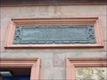 view gallery view gallerySW0.3 km |  1902 - Greenwich Foot Tunnel North Entrance - Island Gardens, Isle of Dogs, London, UK 1902 - Greenwich Foot Tunnel North Entrance - Island Gardens, Isle of Dogs, London, UK
in Dated Buildings and Cornerstones The 1902 Greenwich Foot Tunnel passes beneath the River Thames and connects Greenwich to the Isle of Dogs. At each end of the tunnel is a red bric, domed building that allows access to the tunnel by both stairs and lifts. posted by: Master Mariner location: London, United Kingdom date approved: 02/03/2013 last visited: 01/25/2021 |
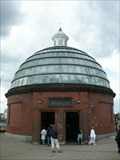 view gallery view gallerySW0.3 km |  Greenwich Foot Tunnel - Greenwich, England, UK Greenwich Foot Tunnel - Greenwich, England, UK
in Official Local Tourism Attractions The Greenwich Foot Tunnel opened in 1902. posted by:  cldisme cldisme location: London, United Kingdom date approved: 07/16/2008 last visited: 12/11/2020 |
 view gallery view gallery SE0.5 km SE0.5 km
| You Are Here - Thames Path, Ballast Quay, Greenwich, UK in 'You Are Here' Maps This is a long path so it helps to know "You are here"!! posted by: Master Mariner location: London, United Kingdom date approved: 05/15/2011 last visited: 09/06/2019 |
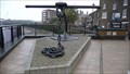
 view gallery view gallerySE0.5 km |  Anchor Iron & Crowley's Wharf - Greenwich, London, UK Anchor Iron & Crowley's Wharf - Greenwich, London, UK
in Satellite Imagery Oddities A commemorative anchor outside the Cutty Sark public house in Greenwich. posted by: Master Mariner location: London, United Kingdom date approved: 12/30/2015 last visited: 04/29/2023 |
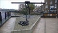
 view gallery view gallerySE0.5 km |  Anchor Iron & Crowley's Wharf - Greenwich, London, UK Anchor Iron & Crowley's Wharf - Greenwich, London, UK
in UK Historical Markers A commemorative anchor outside the Cutty Sark public house in Greenwich. posted by: Master Mariner location: London, United Kingdom date approved: 01/02/2016 last visited: 04/29/2023 |
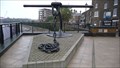
 view gallery view gallerySE0.5 km |  Anchor - Anchor Iron & Crowley's Wharf Anchor - Anchor Iron & Crowley's Wharf
in Anchors A commemorative anchor outside the Cutty Sark public house in Greenwich. posted by: Master Mariner location: London, United Kingdom date approved: 04/29/2011 last visited: 04/29/2023 |
 view gallery view gallerySE0.5 km |  EABM Crowley Wharf - Greenwich, London, UK EABM Crowley Wharf - Greenwich, London, UK
in U.K. and Ireland Trigpoints An EABM near the River Thames at Greenwich. posted by: Master Mariner location: London, United Kingdom date approved: 09/03/2011 last visited: 02/21/2023 |
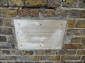
 view gallery view gallerySE0.5 km |  High Bridge Wharf (1928) - Greenwich, UK High Bridge Wharf (1928) - Greenwich, UK
in High Level Marks High tide level marked on the river wall at Greenwich. posted by: Master Mariner location: London, United Kingdom date approved: 05/16/2011 last visited: 11/24/2020 |
 view gallery view gallerySE0.5 km | High Bridge Wharf 1874, Greenwich UK in High Level Marks A high level mark from 1874. posted by: Master Mariner location: London, United Kingdom date approved: 05/16/2011 last visited: 11/23/2020 |
 view gallery view gallery N0.5 km N0.5 km
| You Are Here - Manchester Road, London, UK in 'You Are Here' Maps This "you are here" map is at a docking station for Santander Cycles. This docking station is on the south west side of Manchester Road at Jubilee Crescent after which this docking station is named. posted by: Master Mariner location: London, United Kingdom date approved: 07/30/2016 last visited: never |
 view gallery view galleryN0.5 km | Cubitt Town - Jubilee Crescent, Manchester Road, London, UK in Bicycle Rentals A docking station for Santander Cycles. This docking station is on the south west side of Manchester Road at Jubilee Crescent after which this docking station is named. posted by: Master Mariner location: London, United Kingdom date approved: 07/30/2016 last visited: never |
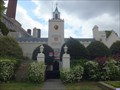 view gallery view gallerySE0.5 km | Trinity Hospital - Greenwich, London, UK in Wikipedia Entries Trinity Hospital is a almshouse and is located adjacent to the River Thames in Greenwich. A tower, on the north west face, has the date as 1616. posted by: Master Mariner location: London, United Kingdom date approved: 01/20/2015 last visited: 09/06/2019 |
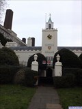
 view gallery view gallerySE0.5 km |  Trinity Hospital Clock - Greenwich, London, UK Trinity Hospital Clock - Greenwich, London, UK
in Town Clocks This closk is mounted on the tower on the north west facade of Trinity Hospital, by the River Thames, in Greenwich. posted by: Master Mariner location: London, United Kingdom date approved: 01/20/2015 last visited: 11/23/2020 |
 view gallery view gallerySE0.5 km | Trinity Hospital - Greenwich, London, UK in Satellite Imagery Oddities Trinity Hospital is an almshouse and is located adjacent to the River Thames in Greenwich. A tower, on the north west face, has the date as 1616. posted by: Master Mariner location: London, United Kingdom date approved: 01/20/2015 last visited: 09/06/2019 |
 view gallery view gallerySE0.5 km |  Henry Howard, 1st Earl of Northampton Coat-of-Arms - Trinity Hospital, Greenwich, UK Henry Howard, 1st Earl of Northampton Coat-of-Arms - Trinity Hospital, Greenwich, UK
in Coats of Arms This coat-of-arms of Henry Howard, 1st Earl of Northampton is on the tower on the north west side of the building close to the River Thames. The coat-of-arms are those of the hospital's founder - Henry Howard. posted by: Master Mariner location: London, United Kingdom date approved: 01/21/2015 last visited: 09/06/2019 |
|