 view gallery view gallery N0.6 km N0.6 km
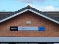
|   Crayford Station - Lower Station Road, Crayford, Kent, UK Crayford Station - Lower Station Road, Crayford, Kent, UK
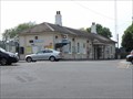
in Wikipedia Entries Crayford railway station serves the services operated by Southeastern. The station is on the north west side of Lower Station Road where the main entrance and ticket office are located. There is a further entrance in Station Approach. posted by:  Master Mariner Master Mariner location: London, United Kingdom date approved: 07/22/2015 last visited: never |
 view gallery view galleryN0.6 km |  Crayford Station - Lower Station Road, Crayford, Kent, UK Crayford Station - Lower Station Road, Crayford, Kent, UK
in Train Stations/Depots Crayford railway station serves the services operated by Southeastern. The station is on the north west side of Lower Station Road where the main entrance and ticket office are located. There is a further entrance in Station Approach. posted by: Master Mariner location: London, United Kingdom date approved: 07/22/2015 last visited: 04/15/2021 |
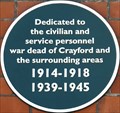 view gallery view galleryN1 km |  Civil and Service Personnel Dead - Crayford Road, Crayford, Kent, UK Civil and Service Personnel Dead - Crayford Road, Crayford, Kent, UK
in Blue Plaques This green plaque, dedicated to the "civiliian and service personnel war dead of Crayford", is mounted on the Old Town Hall. The building is on the south west side of Crayford Road. posted by: Master Mariner location: London, United Kingdom date approved: 07/23/2015 last visited: never |
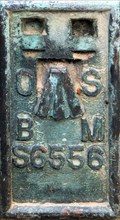
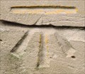
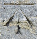
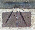 view gallery view galleryN1.1 km |  Cut Bench Mark - Crayford Road, Crayford, Kent, UK Cut Bench Mark - Crayford Road, Crayford, Kent, UK
in U.K. and Ireland Trigpoints This mark is cut into the brickwork of a wall at the junction of Crayford Road and London Road in the centre of Crayford. The mark is to the left side of a bridge that crosses the River Cray. posted by: Master Mariner location: London, United Kingdom date approved: 07/22/2015 last visited: never |
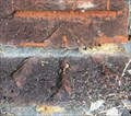
 view gallery view galleryN1.1 km | Cut Bench Mark - Crayford Way, Crayford, Kent, UK in U.K. and Ireland Trigpoints This mark is cut into the parapet of a bridge that crosses the River Cray in Crayford town centre. The mark is on the west side of the bridge at its northern end. posted by: Master Mariner location: London, United Kingdom date approved: 07/22/2015 last visited: never |
 view gallery view galleryN1.3 km | Cut Bench Mark - Crayford High Street, Crayford, Kent, UK in U.K. and Ireland Trigpoints The mark is cut into the brickwork of the Duke's Head public house on the south west side of Crayford High Street. The mark is at the north corner of the building on the north west face. posted by: Master Mariner location: London, United Kingdom date approved: 07/23/2015 last visited: never |
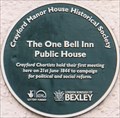 view gallery view galleryN1.3 km |  FIRST - Crayford Chartists Meeting - Old Road, Crayford, Kent, UK FIRST - Crayford Chartists Meeting - Old Road, Crayford, Kent, UK
in First of its Kind This plaque placed by the Crayford Manor House Historical Society marks the place where the Crayford Chartists held their first meeting in 1844. The plaque is mounted on the One Bell Inn public house on the south side of Old Road. posted by: Master Mariner location: London, United Kingdom date approved: 07/23/2015 last visited: never |
 view gallery view galleryN1.3 km |  Crayford Chartists Green Plaque - Old Road, Crayford, Kent, UK Crayford Chartists Green Plaque - Old Road, Crayford, Kent, UK
in News Article Locations This plaque placed by the Crayford Manor House Historical Society marks the place where the Crayford Chartists held their first meeting in 1844. The plaque is mounted on the One Bell Inn public house on the south side of Old Road. posted by: Master Mariner location: London, United Kingdom date approved: 07/23/2015 last visited: never |
 view gallery view galleryN1.3 km | Crayford Chartists - Old Road, Crayford, Kent, UK in Blue Plaques This plaque placed by the Crayford Manor House Historical Society marks the place where the Crayford Chartists held their first meeting in 1844. The plaque is mounted on the One Bell Inn public house on the south side of Old Road. posted by: Master Mariner location: London, United Kingdom date approved: 07/23/2015 last visited: never |
 view gallery view galleryN1.4 km | Flush Bracket - St Paulinus Church, Manor Road, Crayford, Kent, UK in U.K. and Ireland Trigpoints This flush bracket is attached to the north west buttress of the tower of St Paulinus church. The church and churchyard lie between Manor Road and Perry Street in Crayford. posted by: Master Mariner location: London, United Kingdom date approved: 07/23/2015 last visited: never |
 view gallery view galleryN1.4 km |  Flush Bracket - St Paulinus Church, Manor Road, Crayford, Kent, UK Flush Bracket - St Paulinus Church, Manor Road, Crayford, Kent, UK
in European Historic Survey Stones, Monuments and Benchmarks This flush bracket is attached to the north west buttress of the tower of St Paulinus church. The church and churchyard lie between Manor Road and Perry Street in Crayford. posted by: Master Mariner location: London, United Kingdom date approved: 07/23/2015 last visited: never |
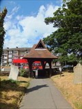 view gallery view galleryN1.4 km |  St Paulinus Church Lychgate - Crayford, UK St Paulinus Church Lychgate - Crayford, UK
in Lychgates and Depositories This lychgate is at the western entrance to the churchyard of St Paulinus church. The lychgate was constructed in 1873 with the church having been built a few hundred years earlier. The lychgate is unusual in that it is hexagonal in plan. posted by: Master Mariner location: London, United Kingdom date approved: 08/18/2019 last visited: never |
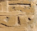
 view gallery view galleryN1.6 km | Cut Bench Mark - Perry Street, Crayford, Kent, UK in U.K. and Ireland Trigpoints This mark is cut into a brickwork gatepost on the west side of Perry Street. The gatepost is on the south side of the entrance into the Russell Stoneham Memorial Gardens. posted by: Master Mariner location: London, United Kingdom date approved: 07/23/2015 last visited: never |
 view gallery view gallery W1.6 km W1.6 km
| Cut Bench Mark - High Street, Old Bexley, London, UK in U.K. and Ireland Trigpoints This mark is cut into the stonework of St Mary's church on the north east side of the High Street. The mark is at the south west corner of the church's tower. posted by: Master Mariner location: London, United Kingdom date approved: 08/25/2014 last visited: never |
 view gallery view galleryW1.6 km | Cut Bench Mark - High Street, Old Bexley, London, UK in European Historic Survey Stones, Monuments and Benchmarks This mark is cut into the stonework of St Mary's church on the north east side of the High Street. The mark is at the south west corner of the church's tower. posted by: Master Mariner location: London, United Kingdom date approved: 08/26/2014 last visited: never |
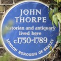 view gallery view galleryW1.6 km | John Thorpe - Bexley High Street, Bexley, UK in Blue Plaques This London Borough of Bexley blue plaque, to John Thorpe, is attached to a house on the north east side of Bexley High Street. posted by: Master Mariner location: London, United Kingdom date approved: 05/18/2014 last visited: 04/15/2021 |
 view gallery view galleryW1.8 km | Cut Bench Mark - High Street, Old Bexley, London, UK in U.K. and Ireland Trigpoints This mark is cut into a rail bridge buttress on the north east side of Old Bexley High Street on the south east side of the bridge. posted by: Master Mariner location: London, United Kingdom date approved: 08/24/2014 last visited: never |
 view gallery view galleryW1.8 km | Cut Bench Mark - High Street, Old Bexley, London, UK in European Historic Survey Stones, Monuments and Benchmarks This mark is cut into a rail bridge buttress on the north east side of Old Bexley High Street on the south east side of the bridge. posted by: Master Mariner location: London, United Kingdom date approved: 08/25/2014 last visited: never |
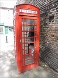
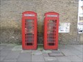 view gallery view galleryW1.8 km |  Red Telephone Boxes - Bourne Road, Old Bexley, London, UK Red Telephone Boxes - Bourne Road, Old Bexley, London, UK
in Red Telephone Boxes This pair of K6 phone boxes are on the south east side of Bourne Road in Old Bexley. They are set back from the road in a recessed area that also has Royal Mail post boxes. posted by: Master Mariner location: London, United Kingdom date approved: 10/11/2014 last visited: never |
 view gallery view galleryW1.9 km | Red Telephone Box - Station Approach, Old Bexley, London, UK in Red Telephone Boxes This K6 phone box is on the east side of Station Approach just south of the junction with Bexley High Street. posted by: Master Mariner location: London, United Kingdom date approved: 10/11/2014 last visited: never |
 view gallery view gallery E1.9 km E1.9 km
| Cut Bench Mark - Dartford Road, Dartford, Kent, UK in U.K. and Ireland Trigpoints This mark is cut into a brickwork gatepost on the north easts side of Dartford Road close to the junction with Lawrence Hill Road. posted by: Master Mariner location: South East England, United Kingdom date approved: 07/21/2015 last visited: never |
 view gallery view galleryW1.9 km | Bexley Mainline Station - Station Approach, Bexley, London, UK in Train Stations/Depots Bexley station, in south east London, serves Southeastern railway services that run between London and Dartford. The station opened in 1866. posted by: Master Mariner location: London, United Kingdom date approved: 09/08/2014 last visited: never |
 view gallery view galleryW1.9 km | Bexley Railway Station - Station Approach, Bexley, London, UK in Wikipedia Entries Bexley station, in south east London, serves Southeastern railway services that run between London and Dartford. The station opened in 1866. posted by: Master Mariner location: London, United Kingdom date approved: 09/05/2014 last visited: never |
 view gallery view galleryW2.1 km | Cut Bench Mark - Hurst Road, Old Bexley, London, UK in U.K. and Ireland Trigpoints This mark is cut into the westernmost point of the Bexley United Reformed Church on the south east side of Hurst Road. posted by: Master Mariner location: London, United Kingdom date approved: 08/24/2014 last visited: never |
 view gallery view galleryW2.1 km | Cut Bench Mark - Hurst Road, Old Bexley, London, UK in European Historic Survey Stones, Monuments and Benchmarks This mark is cut into the westernmost point of the Bexley United Reformed Church on the south east side of Hurst Road. posted by: Master Mariner location: London, United Kingdom date approved: 08/26/2014 last visited: never |
|