 view gallery view gallery SE2.3 km SE2.3 km
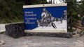
|   CNHS - Édouard-Gaston Deville CNHS - Édouard-Gaston Deville
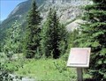
in Canadian National Historic Sites French-born Canadian surveyor of Canadian lands (1875–1924) who perfected the first practical method of photogrammetry, or the making of maps based on photography. posted by:  bcrockcrawler, xstitcher, & BMXer bcrockcrawler, xstitcher, & BMXer location: British Columbia, Canada date approved: 08/08/2008 last visited: 08/01/2014 |
 view gallery view gallery E3.2 km E3.2 km
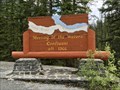
|  Meeting of the Waters ~ Confluent, Canada - 1366 m Meeting of the Waters ~ Confluent, Canada - 1366 m
in Elevation Signs This sign in Yoho National Park, BC, is at the confluence of the Yoho River and Kicking Horse River. posted by: Country_Wife location: British Columbia, Canada date approved: 08/02/2023 last visited: never |
 view gallery view gallery S4.2 km S4.2 km
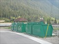
|  DO - Field, British Columbia DO - Field, British Columbia
in Places for Recycling This drop off is located to collect the recyclables and compostables of the town of Field, British Columbia. posted by:  wildwoodke wildwoodke location: British Columbia, Canada date approved: 06/06/2011 last visited: 08/01/2014 |
 view gallery view gallery SW4.2 km SW4.2 km
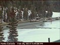
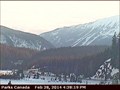
|  Field East Highway Webcam - Field, BC Field East Highway Webcam - Field, BC
in Web Cameras This is one of a pair of web cameras mounted atop the visitor centre, just off Highway 1 at the Field Road. posted by: T0SHEA location: British Columbia, Canada date approved: 03/01/2014 last visited: 07/24/2014 |
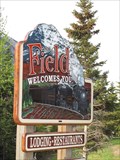 view gallery view gallerySW4.3 km |  Field, British Columbia Field, British Columbia
in Artistic Welcome Signs This welcome sign is found at the bridge into the town of Field, British Columbia. posted by: wildwoodke location: Alberta, Canada date approved: 06/07/2011 last visited: 06/16/2017 |
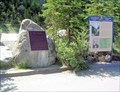
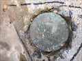
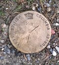 view gallery view gallerySW4.3 km |  1999 - 16569 - BC Legal Survey marker 1999 - 16569 - BC Legal Survey marker
in Canadian Benchmarks 1999 - 16569 - BC Legal Survey marker posted by: Berkut location: British Columbia, Canada date approved: 02/20/2021 last visited: never |
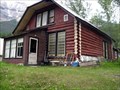 view gallery view galleryS4.3 km |  Canadian Pacific Railway Log Houses Circa 1928, Field, BC Canadian Pacific Railway Log Houses Circa 1928, Field, BC
in British Columbia Heritage Markers This old log home was built about 1928, and was a residence for a railway official. posted by: Queens Blessing location: British Columbia, Canada date approved: 08/22/2011 last visited: 08/01/2014 |
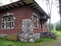 view gallery view galleryS4.3 km |  LAST pre-WWII Railway Building in Field, BC LAST pre-WWII Railway Building in Field, BC
in Last of its Kind This 1931 building is the LAST pre-World War II railway building left standing in the town of Field, British Columbia. posted by: Queens Blessing location: British Columbia, Canada date approved: 08/20/2011 last visited: 08/01/2014 |
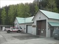 view gallery view galleryS4.3 km |  Yoho National Park Fire Station No. 1 Yoho National Park Fire Station No. 1
in Firehouses Should there be a fire related emergency this Fire Station will provide first response to the town of Field, British Columbia. posted by: wildwoodke location: British Columbia, Canada date approved: 06/06/2011 last visited: never |
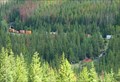
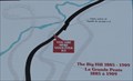 view gallery view galleryE4.3 km |  Short but steep - Field, British Columbia Short but steep - Field, British Columbia
in 'You Are Here' Maps This you are here sign shows the route of the Big Hill rail line and the path of the two spiral tunnels that were constructed to reduce this dangerous stretch of rail track east of Field, British Columbia. posted by: wildwoodke location: British Columbia, Canada date approved: 06/07/2011 last visited: 08/05/2019 |
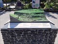 view gallery view galleryE4.3 km |  Spiral Tunnels / Tunnels en spirale - Field, British-Columbia Spiral Tunnels / Tunnels en spirale - Field, British-Columbia
in 3D Map Models of Our World and Beyond This 3D map demonstrates the 8-shape tunnels shovelled in the mountains to make it easier for train engine to travel up. posted by: machard location: British Columbia, Canada date approved: 08/06/2019 last visited: never |
 view gallery view galleryE4.3 km | CNHS - Kicking Horse Pass in Canadian National Historic Sites Kicking Horse Pass (el. 1627 m, 5339 ft) is a high mountain pass across the Continental Divide of the Canadian Rockies on the Alberta/British Columbia border posted by: bcrockcrawler, xstitcher, & BMXer location: British Columbia, Canada date approved: 08/04/2008 last visited: 07/29/2019 |
 view gallery view galleryE4.3 km |  CPR Spiral Tunnels - Field, British Columbia, Canada CPR Spiral Tunnels - Field, British Columbia, Canada
in Active Rail Locations This viewpoint looks down on one of the famous Canadian Pacific Railway spiral tunnels, where visitors can view trains passing over or under themselves, located on the side of the Trans-Canada Highway 7 km east of Field, British Columbia, Canada. posted by: The A-Team location: British Columbia, Canada date approved: 12/14/2014 last visited: 07/29/2019 |
 view gallery view galleryE4.3 km |  Spiral Tunnel Look-out, near Field, BC, Canada Spiral Tunnel Look-out, near Field, BC, Canada
in Scenic Roadside Look-Outs This look-out has parking for about 20 cars, non-flush restrooms, and many interpretive displays of the spiral railroad track in the valley. posted by: Queens Blessing location: British Columbia, Canada date approved: 08/20/2011 last visited: 08/04/2019 |
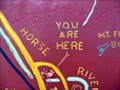
 view gallery view galleryE4.3 km | YOU ARE HERE Spiral Tunnels - Field, British Columbia in 'You Are Here' Maps This "you are here" sign is a graphical representation of the valley below that has the Spiral Tunnels that were constructed to reduce the overall grade of a dangerous stretch of railline east of Field, British Columbia. posted by: wildwoodke location: British Columbia, Canada date approved: 06/07/2011 last visited: 07/29/2019 |
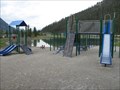 view gallery view gallerySW4.3 km |  Rest Area Playground- Field, British Columbia Rest Area Playground- Field, British Columbia
in Public Playgrounds This playground is located at the rest area for Field, British Columbia. posted by: wildwoodke location: British Columbia, Canada date approved: 06/05/2011 last visited: 06/16/2017 |
 view gallery view gallerySW4.3 km |  The Kicking Horse River - Field, British Columbia The Kicking Horse River - Field, British Columbia
in National Wild and Scenic Rivers The Kicking Horse River is listed on Canada's National Heritage Rivers System. This National Heritage River, the equivalent to a National Wild and Scenic River in the US, is identified by this plaque in Field, British Columbia. posted by: wildwoodke location: Alberta, Canada date approved: 06/01/2012 last visited: 08/04/2019 |
 view gallery view galleryS4.5 km | GCM361162 - Field, BC in Canadian Benchmarks Control survey marker in front of St Joseph's Roman Catholic Church on 1st Avenue in Field, British Columbia. posted by: archway location: British Columbia, Canada date approved: 01/06/2018 last visited: never |
 view gallery view galleryS4.5 km | Field, British Columbia, Canada in 'You Are Here' Maps This HUGE wooden map in Field brags that YOU ARE HERE! posted by: Queens Blessing location: British Columbia, Canada date approved: 08/22/2011 last visited: 09/02/2013 |
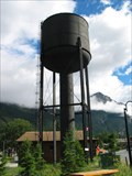 view gallery view galleryS4.5 km |  Field, British Columbia - Old Wood Water Tower Field, British Columbia - Old Wood Water Tower
in Water Towers This is an old wood water tower that is in great repair and looks to still be in use. posted by: pdxmickey location: British Columbia, Canada date approved: 07/23/2006 last visited: 07/12/2011 |
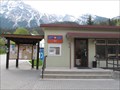 view gallery view gallerySW4.7 km |  Field Post Office V0A 1G0- Field, British Columbia Field Post Office V0A 1G0- Field, British Columbia
in Canada Post Offices This is the small rural post office for Field, British Columbia. posted by: wildwoodke location: British Columbia, Canada date approved: 06/16/2011 last visited: 07/12/2011 |
 view gallery view gallerySW5 km | Field West Highway Webcam - Field, BC in Web Cameras This is one of a pair of web cameras mounted atop the visitor centre, just off Highway 1 at the Field Road. posted by: T0SHEA location: British Columbia, Canada date approved: 03/01/2014 last visited: 07/24/2014 |
 view gallery view gallery W5.1 km W5.1 km
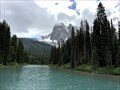
|  Emerald Lake - Yoho National Park, Canada Emerald Lake - Yoho National Park, Canada
in Natural Lakes A very beautiful and popular mountain lake in Yoho National Park, BC, Canada. posted by: Country_Wife location: British Columbia, Canada date approved: 07/31/2023 last visited: never |
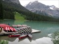 view gallery view galleryW5.1 km |  Emerald Lake Canoeing, Yoho National Park, BC, Canada Emerald Lake Canoeing, Yoho National Park, BC, Canada
in Canoe/Kayak Trips This gorgeous lake has many canoes that can be rented for a special paddle across the emerald-green waters, with the Rockey Mountains as a backdrop! posted by: Queens Blessing location: British Columbia, Canada date approved: 08/31/2011 last visited: 09/19/2018 |
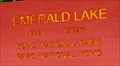 view gallery view galleryW5.3 km | Emerald Lake elevation 1302, Yoho Natl Park, BC, Canada in Elevation Signs This elevation sign is near the parking lot at Emerald Lake. posted by: Queens Blessing location: British Columbia, Canada date approved: 08/20/2011 last visited: 09/19/2018 |
|