 view gallery view gallery NW0.6 km NW0.6 km
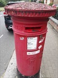
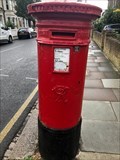
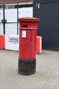
|   Victorian Pillar Box - Elmbourne Road - Tooting - London SW17 - UK Victorian Pillar Box - Elmbourne Road - Tooting - London SW17 - UK
in Victorian Post Boxes A Victorian pillar box on Elmbourne Road in Tooting, London, UK. posted by:  ntpayne ntpayne location: London, United Kingdom date approved: 08/06/2020 last visited: 09/09/2020 |
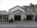
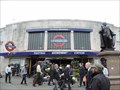
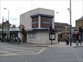 view gallery view galleryNW1.3 km |  Tooting Bec Underground Station - Balham High Road, London, UK Tooting Bec Underground Station - Balham High Road, London, UK
in Wikipedia Entries Tooting Bec tube station serves London Underground's Northern Line. The station has two entrances on opposite sides of the junction formed by Trinity Road, Upper Tooting Road, Balham High Road, Tooting Bec Road and Stapleton Road. posted by:  Master Mariner Master Mariner location: London, United Kingdom date approved: 10/20/2014 last visited: never |
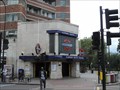
 view gallery view galleryNW1.3 km |  Tooting Bec Underground Station - Balham High Road, London, UK Tooting Bec Underground Station - Balham High Road, London, UK
in The Underground Tooting Bec tube station serves London Underground's Northern Line. The station has two entrances on opposite sides of the junction formed by Trinity Road, Upper Tooting Road, Balham High Road, Tooting Bec Road and Stapleton Road. posted by: Master Mariner location: London, United Kingdom date approved: 10/21/2014 last visited: never |
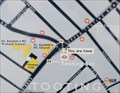 view gallery view galleryNW1.3 km |  You Are Here - Trinity Road, Tooting Bec, London, UK You Are Here - Trinity Road, Tooting Bec, London, UK
in 'You Are Here' Maps This "you are here" map is located on the north east side of Trinity Road at the junction with Balham High Road and outside the northern entrance to Tooting Bec tube station. posted by: Master Mariner location: London, United Kingdom date approved: 10/20/2014 last visited: never |
 view gallery view gallery SW1.4 km SW1.4 km
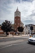
| St Nicholas - Church Lane, Tooting, London, UK in Wikipedia Entries The church of St Nicholas dates from the 11th century but the current building was built in 1833 with construction starting a year, or so, earlier. posted by: Master Mariner location: London, United Kingdom date approved: 07/19/2019 last visited: never |
 view gallery view gallerySW1.4 km |  St Nicholas Church - Church Lane, Tooting, London, UK St Nicholas Church - Church Lane, Tooting, London, UK
in Anglican and Episcopal Churches The church of St Nicholas dates from the 11th century but the current building was built in 1833 with construction starting a year, or so, earlier. posted by: Master Mariner location: London, United Kingdom date approved: 07/23/2019 last visited: never |
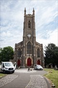 view gallery view gallerySW1.4 km |  St Nicholas Church - Church Lane, Tooting, London, UK St Nicholas Church - Church Lane, Tooting, London, UK
in This Old Church The church of St Nicholas dates from the 11th century but the current building was built in 1833 with construction starting a year, or so, earlier. posted by: Master Mariner location: London, United Kingdom date approved: 07/19/2019 last visited: never |
 view gallery view gallerySW1.4 km | St Boniface RC Church - Mitcham Road, Tooting, London, UK in Roman Catholic Churches St Boniface Roman Catholic church began construction in 1906 and opened for services in 1907 to meet the needs of the local congregation. posted by: Master Mariner location: London, United Kingdom date approved: 07/18/2019 last visited: never |
 view gallery view gallerySW1.4 km | St Boniface RC Church - Mitcham Road, Tooting, London, UK in This Old Church St Boniface Roman Catholic church began construction in 1906 and opened for services in 1907 to meet the needs of the local congregation. posted by: Master Mariner location: London, United Kingdom date approved: 07/17/2019 last visited: never |
 view gallery view galleryNW1.6 km | Balham Station - Balham Station Road, London, UK in Wikipedia Entries Balham station serves both the mainline and underground services. The mainline station is on the south west side of Balham Station Road. A short distance to the northwest, at the end of Balham Station Road, is an entrance to Balham tube station. posted by: Master Mariner location: London, United Kingdom date approved: 10/20/2014 last visited: never |
 view gallery view galleryNW1.6 km |  Balham Mainline Station - Balham Station Road, London, UK Balham Mainline Station - Balham Station Road, London, UK
in Train Stations/Depots Balham mainline railway station, that serves Southern, is on the south west side of Balham Station Road. A short distance to the northwest, at the end of Balham Station Road, is an entrance to Balham tube station. posted by: Master Mariner location: London, United Kingdom date approved: 10/22/2014 last visited: never |
 view gallery view galleryNW1.6 km | Balham Underground Station - Balham High Road, London, UK in The Underground Balham tube station serves London Underground's Northern Line. The entrances are located on the south east and north west sides of Balham High Road at the junction with Balham Station Road where the mainline station is located and Chestnut Grove. posted by: Master Mariner location: London, United Kingdom date approved: 10/19/2014 last visited: never |
 view gallery view gallery W1.8 km W1.8 km
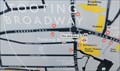
| You Are Here - Mitcham Road, Tooting, London, UK in 'You Are Here' Maps This "you are here" map is located on the south west side of Mitcham Road close to the junction with Tooting High Street and outside Tooting Broadway tube station. posted by: Master Mariner location: London, United Kingdom date approved: 10/20/2014 last visited: never |
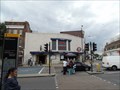
 view gallery view galleryW1.8 km | Tooting Broadway Underground Station - Tooting High Street, London, UK in Wikipedia Entries Tooting Broadway tube station serves London Underground's Northern Line. The entrance is located on the south east side of Tooting High Street at the junction with Mitcham Road. The platforms and tracks are underground. posted by: Master Mariner location: London, United Kingdom date approved: 10/20/2014 last visited: never |
 view gallery view galleryW1.8 km | Tooting Broadway Underground Station - Tooting High Street, London, UK in The Underground Tooting Broadway tube station serves London Underground's Northern Line. The entrance is located on the south east side of Tooting High Street at the junction with Mitcham Road. The platforms and tracks are underground. posted by: Master Mariner location: London, United Kingdom date approved: 10/21/2014 last visited: never |
 view gallery view gallerySW1.8 km | Victorian Pillar Box - Charlmont Road, Tooting, SW London, UK in Victorian Post Boxes A Victorian pillar box in Tooting, SW London, UK. Box number SW17 46. posted by: ntpayne location: London, United Kingdom date approved: 06/15/2019 last visited: 07/11/2019 |
 view gallery view gallery N2.4 km N2.4 km
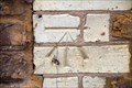
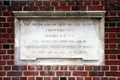
|  Cut Bench Mark - Lysias Road, London, UK Cut Bench Mark - Lysias Road, London, UK
in U.K. and Ireland Trigpoints This mark is cut into the brickwork of a building at the junction of Lysias Road and Alderbrook Road. The mark is on the north west face of the building at its north corner. posted by: Master Mariner location: London, United Kingdom date approved: 02/03/2018 last visited: never |
 view gallery view galleryN2.4 km |  H M Bateman - Nightingale Lane, London, UK H M Bateman - Nightingale Lane, London, UK
in Blue Plaques This English Heritage blue plaque indicates that the cartoonist, H M Bateman, "lived here 1910 - 1914". The plaque is attached to a building on the north west side of Nightingale Lane. posted by: Master Mariner location: London, United Kingdom date approved: 02/03/2018 last visited: never |
 view gallery view galleryN2.6 km | Clapham South Underground Station - Balham Hill, London, UK in Wikipedia Entries Clapham South tube station serves London Underground's Northern Line. The entrance and ticket hall are on the north west side of Balham Hill at the junction with Nightingale Lane. The platform and tracks are underground. posted by: Master Mariner location: London, United Kingdom date approved: 10/19/2014 last visited: 06/27/2021 |
 view gallery view galleryN2.6 km | Clapham South Underground Station - Balham Hill, London, UK in The Underground Clapham South tube station serves London Underground's Northern Line. The entrance and ticket hall are on the north west side of Balham Hill at the junction with Nightingale Lane. The platform and tracks are underground. posted by: Master Mariner location: London, United Kingdom date approved: 10/19/2014 last visited: 12/21/2020 |
 view gallery view galleryN2.6 km | Victorian Post Box - Nightingale Lane, London, UK in Victorian Post Boxes This Victorian post box is located on the south side of Nightingale Lane facing Clapham Common. posted by: Master Mariner location: London, United Kingdom date approved: 02/05/2018 last visited: never |
 view gallery view galleryN2.6 km |  South London Hospital for Women and Children - Clapham Common South Side, London, UK South London Hospital for Women and Children - Clapham Common South Side, London, UK
in Grand Opening The South London Hospital for Women and Children was officially opened by Queen Mary on 4th July, 1916 with construction having started in 1913.The building is located on the south east side of Clapham Common opposite Clapham South tube station. posted by: Master Mariner location: London, United Kingdom date approved: 09/22/2017 last visited: never |
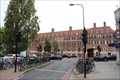 view gallery view galleryN2.6 km | South London Hospital for Women and Children - Clapham Common South Side, London, UK in Wikipedia Entries The South London Hospital for Women and Children was officially opened by Queen Mary on 4th July, 1916 with construction having started in 1913.The building is located on the south east side of Clapham Common opposite Clapham South tube station. posted by: Master Mariner location: London, United Kingdom date approved: 09/21/2017 last visited: never |
![Image for [Former] South London Hospital for Women and Children - Clapham Common South Side, London, UK](https://img.geocaching.com/waymarking/small/678d4f9a-24ff-4a55-89fa-0bfc7cda7726.jpg) view gallery view galleryN2.6 km |  [Former] South London Hospital for Women and Children - Clapham Common South Side, London, UK [Former] South London Hospital for Women and Children - Clapham Common South Side, London, UK
in Satellite Imagery Oddities The South London Hospital for Women and Children was officially opened by Queen Mary on 4th July, 1916 with construction having started in 1913.The building is located on the south east side of Clapham Common opposite Clapham South tube station. posted by: Master Mariner location: London, United Kingdom date approved: 09/22/2017 last visited: never |
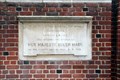
 view gallery view galleryN2.6 km |  1913 - South London Hospital for Women and Children - Clapham Common South Side, London, UK 1913 - South London Hospital for Women and Children - Clapham Common South Side, London, UK
in Dated Buildings and Cornerstones The South London Hospital for Women and Children was officially opened by Queen Mary on 4th July, 1916 with construction having started in 1913.The building is located on the south east side of Clapham Common opposite Clapham South tube station. posted by: Master Mariner location: London, United Kingdom date approved: 09/22/2017 last visited: never |
|