 view gallery view gallery NW0.6 km NW0.6 km
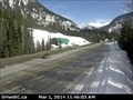
|   Albert Canyon Web Camera - Rogers Pass, BC Albert Canyon Web Camera - Rogers Pass, BC
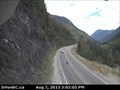
in Web Cameras This BC Highways Webcam is on Highway 1 at the chain up area sign about 32 km east of Revelstoke. posted by:  T0SHEA T0SHEA location: British Columbia, Canada date approved: 03/02/2014 last visited: 07/28/2014 |
 view gallery view gallery SW1.4 km SW1.4 km
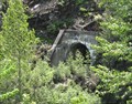
|  Canadian Pacific Tunnel - Canyon Hot Springs, British Columbia Canadian Pacific Tunnel - Canyon Hot Springs, British Columbia
in Abandoned Train Tunnels With a little more blasting and the need for two tracks, this tunnel on the Canadian Pacific Railway was abandoned near Canyon Hot Springs, British Columbia. posted by:  wildwoodke wildwoodke location: British Columbia, Canada date approved: 06/11/2011 last visited: 04/30/2014 |
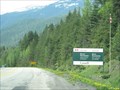 view gallery view gallerySW2.6 km |  Mount Revelstoke National Park, British Columbia, Canada Mount Revelstoke National Park, British Columbia, Canada
in National Parks of the World Mount Revelstoke National Park is located along the TransCanada Highway east of the town of Revelstoke, British Columbia. posted by: wildwoodke location: British Columbia, Canada date approved: 01/01/2012 last visited: 07/18/2017 |
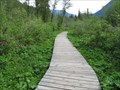 view gallery view gallerySW6.3 km |  Skunk Cabbage Boardwalk - Revelstoke, British Columbia Skunk Cabbage Boardwalk - Revelstoke, British Columbia
in Non-Coastal Boardwalks The Skunk Cabbage Boardwalk is a 1.2 kilometre nature trail that allows access to and protects a natural wetland community that is found in Mount Revelstoke National Park near Revelstoke, British Columbia. posted by: wildwoodke location: British Columbia, Canada date approved: 01/07/2012 last visited: never |
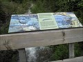 view gallery view gallerySW6.3 km |  American Dipper - Skunk Cabbage Boardwalk - Mount Revelstoke National Park, British Columbia American Dipper - Skunk Cabbage Boardwalk - Mount Revelstoke National Park, British Columbia
in Flora and Fauna Information Signs The American Dipper is a bird that frequents this valley bottom wetland at the Skunk Cabbage Boardwalk in Mount Revelstoke National Park, British Columbia. posted by: wildwoodke location: British Columbia, Canada date approved: 01/04/2012 last visited: never |
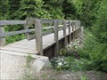 view gallery view gallerySW6.3 km |  Bridge over an unnamed creek - Revelstoke, British Columbia Bridge over an unnamed creek - Revelstoke, British Columbia
in Hiking Path Footbridges This bridge crosses over a creek and connects to the hiking trail and Skunk Cabbage Boardwalk that is a nature trail through a mountain wetland in Mount Revelstoke National Park 28 km east of Revelstoke, British Columbia posted by: wildwoodke location: Alberta, Canada date approved: 01/01/2012 last visited: never |
 view gallery view gallery NE11.6 km NE11.6 km
| Jack McDonald Snowshed Webcam - Rogers Pass, BC in Web Cameras This BC Highways Webcam is at the Jack McDonald snowshed on the climb from the west up to Rogers Pass Summit. posted by: T0SHEA location: British Columbia, Canada date approved: 08/08/2013 last visited: 01/15/2014 |
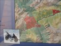 view gallery view galleryNE17.7 km |  You are Here - Bostock Trail - Rogers Pass, British Columbia You are Here - Bostock Trail - Rogers Pass, British Columbia
in 'You Are Here' Maps This you are here map is for the trail head for the Bostock Trail in Rogers Pass, British Columbia. posted by: wildwoodke location: British Columbia, Canada date approved: 06/13/2011 last visited: 08/05/2014 |
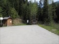
 view gallery view galleryNE17.7 km |  Bostock - Rogers Pass, British Columbia Bostock - Rogers Pass, British Columbia
in Hiking and walking trailheads This is the trail head for the Bostock Trail in Rogers Pass, British Columbia. posted by: wildwoodke location: British Columbia, Canada date approved: 06/12/2011 last visited: 08/05/2014 |
 view gallery view galleryNE17.7 km |  Bostock Creek Trail - Rogers Pass, British Columbia Bostock Creek Trail - Rogers Pass, British Columbia
in Cross Country Ski Trailheads This is the trail head for the Bostock Creek Trail, hiking in the summer and cross-country skiing in the long winter of the Rogers Pass, British Columbia. posted by: wildwoodke location: British Columbia, Canada date approved: 06/15/2011 last visited: 08/05/2014 |
 view gallery view gallery W17.9 km W17.9 km
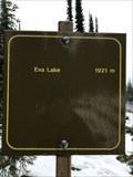
|  1921 m - Eva lake - Elevation signe - Revelstoke - BC - 1921 m. 1921 m - Eva lake - Elevation signe - Revelstoke - BC - 1921 m.
in Elevation Signs Altitude sign at the edge of Eva Lake posted by: franketmuriel location: British Columbia, Canada date approved: 11/08/2018 last visited: never |
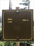 view gallery view galleryW18 km | 1891 m - Miller lake - Elevation signe - Revelstoke - BC - Canada in Elevation Signs Altitude sign at the edge of Miller Lake. posted by: franketmuriel location: British Columbia, Canada date approved: 11/08/2018 last visited: never |
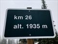 view gallery view gallerySW21.4 km | Elevation Sign KM26 - Revelstoke - BC - Canada. 1935m in Elevation Signs Altitude sign on the road, Meadows in the Sky Parkway, to Mount Revelstoke. This is the end of the road at km 26 posted by: franketmuriel location: British Columbia, Canada date approved: 10/07/2018 last visited: never |
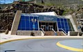
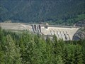 view gallery view galleryW24.6 km |  Revelstoke Dam Visitor Centre - Revelstoke, BC, Canada Revelstoke Dam Visitor Centre - Revelstoke, BC, Canada
in Official Local Tourism Attractions Three km North of Revelstoke, this is the largest hydro dam on the upper Columbia River. posted by: T0SHEA location: British Columbia, Canada date approved: 06/21/2013 last visited: 03/13/2014 |
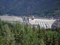 view gallery view galleryW24.6 km |  Revelstoke Dam. Revelstoke, BC, Canada Revelstoke Dam. Revelstoke, BC, Canada
in Water Dams Three km North of Revelstoke, this is the largest hydro dam on the upper Columbia River. posted by: T0SHEA location: British Columbia, Canada date approved: 12/05/2012 last visited: 08/01/2014 |
 view gallery view galleryW24.6 km |  Revelstoke Dam. Revelstoke, BC, Canada Revelstoke Dam. Revelstoke, BC, Canada
in Wikipedia Entries Three km north of Revelstoke, this is the largest hydro dam on the upper Columbia River, in terms of its power output. posted by: T0SHEA location: British Columbia, Canada date approved: 12/11/2012 last visited: 08/01/2014 |
 view gallery view galleryW24.6 km |  BC Hydro submits application for sixth generating unit at Revelstoke dam BC Hydro submits application for sixth generating unit at Revelstoke dam
in News Article Locations Three km North of Revelstoke, this is the largest hydro dam on the upper Columbia River. posted by: T0SHEA location: British Columbia, Canada date approved: 04/25/2017 last visited: never |
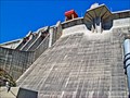
 view gallery view galleryW24.6 km |  Revelstoke Dam - Revelstoke, BC Revelstoke Dam - Revelstoke, BC
in Satellite Imagery Oddities Three km North of Revelstoke, this is the largest hydro dam on the upper Columbia River. posted by: T0SHEA location: British Columbia, Canada date approved: 09/16/2016 last visited: never |
 view gallery view galleryW24.6 km |  Revelstoke Dam - Revelstoke, BC, Canada Revelstoke Dam - Revelstoke, BC, Canada
in Hydroelectric Power Stations Three km North of Revelstoke, this is the largest hydro dam on the upper Columbia River. posted by: T0SHEA location: British Columbia, Canada date approved: 12/04/2012 last visited: 08/01/2014 |
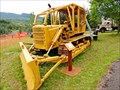 view gallery view gallerySW25.3 km |  Caterpillar D6 - Revelstoke, BC Caterpillar D6 - Revelstoke, BC
in Old Tractors On our most recent trip through Revelstoke we made another visit to the BC Interior Forestry Museum, which is just west of the Revelstoke Dam. posted by: T0SHEA location: British Columbia, Canada date approved: 02/03/2016 last visited: never |
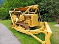 view gallery view gallerySW25.3 km | Caterpillar RD-6 - Revelstoke, BC in Old Tractors On our most recent trip through Revelstoke we made another visit to the BC Interior Forestry Museum, which is just west of the Revelstoke Dam. posted by: T0SHEA location: British Columbia, Canada date approved: 02/03/2016 last visited: never |
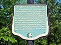 view gallery view gallerySW25.3 km |  River of the West - Revelstoke, BC River of the West - Revelstoke, BC
in British Columbia Heritage Markers This historic marker is displayed at the BC Interior Forestry Museum, at the turn off to the Revelstoke Dam, about 2.5 km. up the Big Bend Highway from the northern outskirts of Revelstoke. posted by: T0SHEA location: British Columbia, Canada date approved: 04/18/2013 last visited: 02/18/2014 |
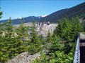
 view gallery view gallerySW25.4 km |  BC Forestry Museum - Revelstoke, BC BC Forestry Museum - Revelstoke, BC
in Lucky 7 The museum is located at the entrance to the Revelstoke Dam visitor centre, north of Revelstoke on Highway 23 (The Big Bend Highway). This Lucky 7 takes in the museum and a peek at the Revelstoke Dam, just to the north. posted by: T0SHEA location: British Columbia, Canada date approved: 04/25/2017 last visited: never |
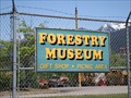
 view gallery view gallerySW25.4 km | BC Interior Forestry Museum - Revelstoke, BC in Official Local Tourism Attractions The museum is located at the entrance to the Revelstoke Dam visitor centre, north of Revelstoke on Highway 23 (The Big Bend Highway). posted by: T0SHEA location: British Columbia, Canada date approved: 02/11/2015 last visited: never |
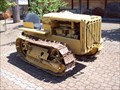 view gallery view gallerySW25.4 km | Caterpillar Twenty Two - Revelstoke Forestry Museum - Revelstoke, BC in Old Tractors This Cat is on display at the BC Forestry Museum. The museum is located at the entrance to the Revelstoke Dam visitor centre, north of Revelstoke on Highway 23 (The Big Bend Highway). posted by: T0SHEA location: British Columbia, Canada date approved: 04/22/2013 last visited: 01/04/2014 |
|