 view gallery view gallery SW10.8 km SW10.8 km
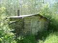
|   Moggey's Cabin - near Eriksdale MB Moggey's Cabin - near Eriksdale MB
in Unoccupied Buildings, Shacks, and Cabins This neat old abandoned hideout of Percy Moggey is on crown land about 5 miles north of Eriksdale Manitoba. posted by:  PeterNoG PeterNoG location: Manitoba, Canada date approved: 07/10/2008 last visited: 08/28/2015 |
 view gallery view gallery W13.4 km W13.4 km
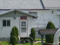
|  MULVIHILL PO R0C 2G0 MULVIHILL PO R0C 2G0
in Canada Post Offices This post office is right on Hwy 6, 2.6 km north of Hwy 68 in Mulvihill, Manitoba. posted by: PeterNoG location: Manitoba, Canada date approved: 12/14/2010 last visited: 09/05/2010 |
 view gallery view gallery S16.7 km S16.7 km
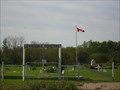
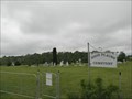
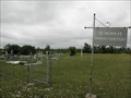
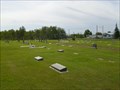
|  Eriksdale Cemetery - Eriksdale MB Eriksdale Cemetery - Eriksdale MB
in Worldwide Cemeteries This cemetery is just east of Eriksdale on Hwy 68 in the Rural Municipality of Eriksdale. posted by: PeterNoG location: Manitoba, Canada date approved: 11/08/2010 last visited: 07/09/2011 |
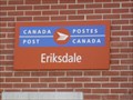 view gallery view gallerySW16.9 km | ERIKSDALE PO R0C 0W0 in Canada Post Offices A typical rural post office design, this one is at 3 Main St in Eriksdale, Manitoba. posted by: PeterNoG location: Manitoba, Canada date approved: 12/14/2010 last visited: 09/05/2010 |
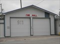
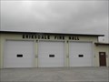 view gallery view gallerySW17.2 km |  Eriksdale Fire Hall Eriksdale Fire Hall
in Firehouses This Firehouse for the Eriksdale Volunteer Fire Department is on South Drive just south of Hwy 68 (Vimy Road) in the community of Eriksdale in the Rural Municipality of Eriksdale, Manitoba. posted by: PeterNoG location: Manitoba, Canada date approved: 10/28/2011 last visited: 07/09/2011 |
 view gallery view gallery NW20 km NW20 km
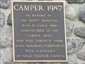
|  MHM Camper 1987 MHM Camper 1987
in Manitoba Historical Markers This Manitoba Historical Marker is mounted on a large stone cairn near the Community Centre in the community of Camper, Manitoba. posted by: PeterNoG location: Manitoba, Canada date approved: 04/18/2012 last visited: 07/09/2011 |
 view gallery view gallery SE26.1 km SE26.1 km
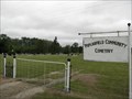
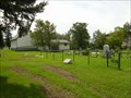
| High Plains Cemetery - Poplarfield MB in Worldwide Cemeteries This cemetery is just south of Hwy 68, 4.8 km (3 mi.) west of Poplarfield in the Rural Municipality of Fisher, Manitoba. posted by: PeterNoG location: Manitoba, Canada date approved: 09/20/2011 last visited: 07/09/2011 |
 view gallery view gallerySE29 km | Poplarfield Community Cemetery - Poplarfield MB in Worldwide Cemeteries This cemetery is just north of Hwy 68, 1.6 km (1 mi.) west of Poplarfield in the Rural Municipality of Fisher, Manitoba. posted by: PeterNoG location: Manitoba, Canada date approved: 09/20/2011 last visited: 07/09/2011 |
 view gallery view gallerySE29.5 km | St Nicholas Parish Cemetery - Poplarfield MB in Worldwide Cemeteries This cemetery is south of Hwy 68, 1.1 km (0.7 mi.) west of Poplarfield in the Rural Municipality of Fisher, Manitoba. posted by: PeterNoG location: Manitoba, Canada date approved: 09/20/2011 last visited: 07/09/2011 |
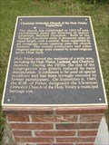 view gallery view gallerySE30.3 km | MHM Ukrainian Orthodox Church of the Holy Trinity - Poplarfield MB in Manitoba Historical Markers This Manitoba Historical Marker is in front of the Ukrainian Orthodox Church of the Holy Trinity on Highway 68 in Poplarfield, Manitoba. It's about 230 metres west of Hwy 17. posted by: PeterNoG location: Manitoba, Canada date approved: 11/14/2011 last visited: 03/14/2012 |
 view gallery view gallerySE30.4 km | Poplarfield PO R0C 2N0 in Canada Post Offices One stop shopping in Poplarfield. The Post Office is in King Buck Inn which is a Licensed Restaurant, a Convenience Store, a Liquor Vendor and a Tempo Gas Station. It's on Hwy 17 at Hwy 68. posted by: PeterNoG location: Manitoba, Canada date approved: 08/31/2011 last visited: 07/09/2011 |
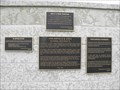 view gallery view gallerySE30.4 km | MHM Poplarfield & Area School Districts in Manitoba Historical Markers This Manitoba Historical Marker is King Buck Park at Hwy 68 and Hwy 17 in Poplarfield, Manitoba. posted by: PeterNoG location: Manitoba, Canada date approved: 04/18/2012 last visited: 07/09/2011 |
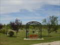
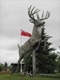 view gallery view gallerySE30.4 km |  King Buck - Poplarfield MB King Buck - Poplarfield MB
in Roadside Attractions This Roadside Attraction is a in a park on the southwest corner of Highway 68 and Highway 17 in Poplarfield, Manitoba. posted by: PeterNoG location: Manitoba, Canada date approved: 11/01/2011 last visited: 07/09/2011 |
 view gallery view galleryNW31.4 km | Ashern Roman Catholic Cemetery - Ashern MB in Worldwide Cemeteries There is no signage here at the southeast corner of Palliser Ave & Hwy 325 in Ashern, Manitoba, but this is the Ashern Roman Catholic Cemetery.
This is the Rural Municipality of Siglunes. posted by: PeterNoG location: Manitoba, Canada date approved: 11/04/2010 last visited: 07/09/2011 |
 view gallery view galleryNW31.5 km | ASHERN PO R0C 0E0 in Canada Post Offices This traditional rural post office is at 32 Main St in Ashern, Manitoba. posted by: PeterNoG location: Manitoba, Canada date approved: 12/14/2010 last visited: 09/05/2010 |
 view gallery view galleryNW31.7 km | Ashern United Church Cemetery - Ashern MB in Worldwide Cemeteries This Cemetery is on Hwy 325, 350 meters east of Hwy 6 in Ashern, Manitoba in the Rural Municipality of Siglunes. posted by: PeterNoG location: Manitoba, Canada date approved: 05/05/2014 last visited: 09/05/2010 |
 view gallery view galleryNW31.7 km |  Ashern United Church Cemetery - Ashern Ashern United Church Cemetery - Ashern
in Churchyard Cemeteries This church and cemetery is on Hwy 325, 350 meters east of Hwy 6 in Ashern, Manitoba in the Rural Municipality of Siglunes. posted by: PeterNoG location: Manitoba, Canada date approved: 11/02/2010 last visited: 09/05/2010 |
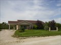 view gallery view galleryNW31.9 km |  Kingdom Halls of Jehovah's Witnesses - Ashern MB Kingdom Halls of Jehovah's Witnesses - Ashern MB
in Kingdom Halls of Jehovah's Witnesses This Kingdom Hall is at 15 Hwy 6 (just south of Hwy 325) in Ashern, Manitoba. posted by: PeterNoG location: Manitoba, Canada date approved: 11/20/2010 last visited: 12/30/2011 |
 view gallery view galleryNW32 km | Sharptail Grouse - Ashern MB in Roadside Attractions This 17 foot high Sharptail Grouse is in a small campground called Sharptail Park on Hwy 6 in Ashern, Manitoba. posted by: PeterNoG location: Manitoba, Canada date approved: 11/20/2010 last visited: 12/30/2011 |
 view gallery view galleryNW32.3 km | Grace Lutheran Cemetery - Ashern MB in Worldwide Cemeteries This is the southernmost of two cemetery on Hwy 6, 0.5 km north of Ashern, Manitoba in the Rural Municipality of Siglunes. posted by: PeterNoG location: Manitoba, Canada date approved: 11/08/2010 last visited: 12/30/2011 |
 view gallery view galleryNW32.3 km | Ashern Municipal Cemetery / Ashern Community Cemetery - Ashern MB in Worldwide Cemeteries This is the northernmost of two cemetery on Hwy 6, 0.5 km north of Ashern, Manitoba in the Rural Municipality of Siglunes. posted by: PeterNoG location: Manitoba, Canada date approved: 07/07/2016 last visited: 09/05/2010 |
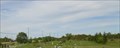
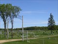 view gallery view galleryS33.5 km | Lundar Cemetery 1987 - Lundar MB in Worldwide Cemeteries This cemetery is on Hwy 6 on the north side of Lundar, Manitoba in the Rural Municipality of Coldwell. posted by: PeterNoG location: Manitoba, Canada date approved: 11/08/2010 last visited: 12/30/2011 |
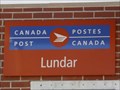 view gallery view galleryS34 km | LUNDAR PO R0C 1Y0 in Canada Post Offices A typical rural post office design, this one is at 14 Main St in Lundar, Manitoba. posted by: PeterNoG location: Manitoba, Canada date approved: 12/14/2010 last visited: 07/09/2011 |
 view gallery view galleryS34 km | Fire Hall in Firehouses This Firehouse for the Coldwell Fire Department is on Main Street between 2nd Avenue and 3rd Avenue in Lundar in the Rural Municipality of Coldwell, Manitoba. posted by: PeterNoG location: Manitoba, Canada date approved: 10/23/2011 last visited: 07/09/2011 |
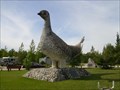
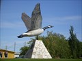 view gallery view galleryS34.1 km | Canada Goose - Lundar MB in Roadside Attractions This Canada Goose, with a wingspan of 20 feet, was built in 1978 and is in a roadside park on Hwy 6 in Lundar, Manitoba. posted by: PeterNoG location: Manitoba, Canada date approved: 11/19/2010 last visited: 05/05/2017 |
|