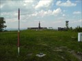
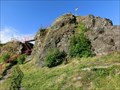
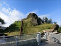
 view gallery view gallery N0.6 km N0.6 km
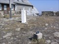
|   TB 0707-3 Luz TB 0707-3 Luz
in Czech Geodetic Points Geodeticky bod na vrcholu hory Luz ve vysce 793 m n.m. posted by:  bodlak bodlak location: Liberecký kraj, Czechia date approved: 06/05/2011 last visited: 06/11/2020 |
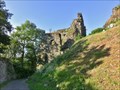
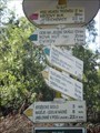
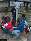
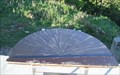 view gallery view galleryN0.8 km |  Lausche (Luž) Orientation Tables Lausche (Luž) Orientation Tables
in Orientation Tables Two orientation tables at Lausche (Czech: Luž) mountain, 793m ASL. posted by:  haggaeus haggaeus location: Sachsen, Germany date approved: 05/10/2011 last visited: 04/23/2023 |
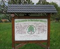
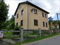 view gallery view gallery SE4 km SE4 km
|  Krompach v Cechách - 471 57, Krompach v Cechách, Czech Republic Krompach v Cechách - 471 57, Krompach v Cechách, Czech Republic
in European Post Offices Local post office in Krompach 186, Krompach v Cechách posted by: ToRo61 location: Liberecký kraj, Czechia date approved: 07/03/2017 last visited: never |
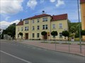
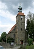 view gallery view gallery E4.3 km E4.3 km
|  Evangelisch-Lutherische Kirche - Jonsdorf, DE Evangelisch-Lutherische Kirche - Jonsdorf, DE
in Lutheran Churches 18th century town church. posted by: haggaeus location: Sachsen, Germany date approved: 05/10/2012 last visited: 06/04/2023 |
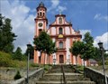 view gallery view gallerySE4.5 km | Church of St. Mary Magdalene - Marenice, Czech Republic in Roman Catholic Churches The Pilgrimage Church of St. Mary Magdalene in Marenice posted by: ToRo61 location: Liberecký kraj, Czechia date approved: 07/24/2017 last visited: 06/07/2018 |
 view gallery view gallerySE4.5 km |  No. 1398, Marenice, Poutni kostel Mari Magdaleny, CZ No. 1398, Marenice, Poutni kostel Mari Magdaleny, CZ
in Tourist Stamps Photos Marenice, Poutni kostel Mari Magdaleny // Pilgrimage Church of St. Mary Magdalene in Marenice posted by: ToRo61 location: Liberecký kraj, Czechia date approved: 08/05/2017 last visited: 06/07/2018 |
 view gallery view gallery S4.7 km S4.7 km
| TB 0707-15 Travnicky kopec in Czech Geodetic Points TB na vrcholu Travnickeho vrchu, 517m n.m. posted by: haggaeus location: Liberecký kraj, Czechia date approved: 05/10/2011 last visited: never |
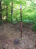
 view gallery view gallery NE4.7 km NE4.7 km
|  TP southwest of Bertsdorf, SX TP southwest of Bertsdorf, SX
in German Trigonometric Points A trigonometric point in the meadows between Jonsdorf and Bertsdorf. posted by: haggaeus location: Sachsen, Germany date approved: 05/09/2012 last visited: never |
 view gallery view gallery W5 km W5 km
|  Tolstejn - Czech Republic Tolstejn - Czech Republic
in Scenic Overlooks Scenic Overlook from top of Tolstejn Hill posted by: ToRo61 location: Ústecký kraj, Czechia date approved: 07/24/2017 last visited: 06/11/2020 |
 view gallery view galleryW5 km |  Tolstejn - North Bohemia, Czech Republic Tolstejn - North Bohemia, Czech Republic
in Castles Tolstejn Castle posted by: ToRo61 location: Ústecký kraj, Czechia date approved: 07/24/2017 last visited: 06/11/2020 |
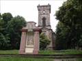
 view gallery view galleryW5 km |  Ruins of Castle Tolštejn - Jiretín pod Jedlovou, Czech Republic Ruins of Castle Tolštejn - Jiretín pod Jedlovou, Czech Republic
in Preserved Architectural Remnants and Ruins CS: Zrícenina hradu Tolštejn // EN: Ruins of Castle Tolštejn posted by: ALMOR team location: Ústecký kraj, Czechia date approved: 07/21/2015 last visited: 06/11/2020 |
 view gallery view galleryW5 km |  Tolštejn Castle - Jiretín pod Jedlovou, Czech Republic Tolštejn Castle - Jiretín pod Jedlovou, Czech Republic
in Wikipedia Entries CS: Zrícenina hradu Tolštejn // EN: Tolštejn Castle posted by: ALMOR team location: Ústecký kraj, Czechia date approved: 07/21/2015 last visited: 06/11/2020 |
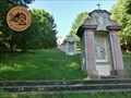
 view gallery view gallerySE5 km |  Krizek na kopci Kalvarie - Marenice, CZ Krizek na kopci Kalvarie - Marenice, CZ
in Christian Crosses CZ: Kriz na kopci Kalvarie nad obci Marenice.
EN: Cross on the hill above the village Marenice. posted by: jezevecjezevec location: Liberecký kraj, Czechia date approved: 08/14/2013 last visited: never |
 view gallery view gallerySE5.1 km | TB 0707-16 Kalvarie in Czech Geodetic Points Bod je umisten na kopci Kalvarie, jizne od obce Marenice. posted by: jezevecjezevec location: Liberecký kraj, Czechia date approved: 08/13/2013 last visited: never |
 view gallery view galleryW5.1 km |  Sightseeing platform - Tolstejn, Czech Republic Sightseeing platform - Tolstejn, Czech Republic
in Look-Out Towers Sightseeing platform on top of Tolstejn Hill and Castle posted by: ToRo61 location: Ústecký kraj, Czechia date approved: 07/24/2017 last visited: 06/11/2020 |
 view gallery view galleryW5.5 km |  Direction and Distance Arrows - Jedlova - zst., Jiretin pod Jedlovou, Czech Republic Direction and Distance Arrows - Jedlova - zst., Jiretin pod Jedlovou, Czech Republic
in Direction and Distance Arrows Direction and Distance Arrows in Jiretín pod Jedlovou posted by: castorka location: Ústecký kraj, Czechia date approved: 02/01/2022 last visited: never |
 view gallery view galleryNE5.5 km |  Bertsdorf-Hörnitz - SX, DE Bertsdorf-Hörnitz - SX, DE
in Artistic Welcome Signs A welcome sign at the southern end of Bertsdorf-Hörnitz village. posted by: haggaeus location: Sachsen, Germany date approved: 05/10/2012 last visited: 11/29/2020 |
 view gallery view gallery NW5.6 km NW5.6 km
| Dolní Podluží - 407 55, Dolní Podluží, Czech Republic in European Post Offices Local post office in Dolní Podluží 6 posted by: ToRo61 location: Ústecký kraj, Czechia date approved: 07/03/2017 last visited: never |
 view gallery view gallerySE6 km |  Monocular at summit of Hochwald (Hvozd) Mt. (Saxony) Monocular at summit of Hochwald (Hvozd) Mt. (Saxony)
in Coin-Op Binoculars The depicted monocular you can find in visitors terrace at the summit of Hochwald (Hvozd) Mt., located directly at Saxony (DE) - North Bohemian (CZ) borders in Lusatian mountains (Lužické hory). posted by: Dorcadion Team location: Sachsen, Germany date approved: 03/02/2010 last visited: 11/27/2020 |
 view gallery view gallerySE6 km | TB 0707-12 Hvozd in Czech Geodetic Points Trigonometricky bod na hranicnim vrcholu Hvozd (Hochwald) ve vysce 750 m n.m. posted by: bodlak location: Liberecký kraj, Czechia date approved: 04/05/2009 last visited: 08/20/2015 |
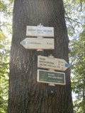 view gallery view galleryS6.1 km | Turisticky ukazatel "KRIZOVY VRCH - KALVARIE - 437 m n.m.", Czech Republic in Direction and Distance Arrows CZ: Rozcestnik turistickych tras u obce Cvikov.
EN: Direction and Distance Arrows of tourist paths near the village Cvikov. posted by: jezevecjezevec location: Liberecký kraj, Czechia date approved: 09/05/2013 last visited: 09/25/2016 |
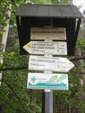 view gallery view galleryS6.3 km | Turisticky ukazatel "SCHILLEROVA VYHLIDKA", Czech Republic in Direction and Distance Arrows CZ: Rozcestnik turistickych tras nad obci Cvikov.
EN: Direction and Distance Arrows of tourist paths above the village Cvikov. posted by: jezevecjezevec location: Liberecký kraj, Czechia date approved: 09/05/2013 last visited: never |
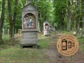 view gallery view galleryS6.3 km | No. 1469, Mesto Cvikov - Kalvarie, CZ in Tourist Stamps Photos Cvikov town and Outdoor Stations of the Cross posted by: ToRo61 location: Liberecký kraj, Czechia date approved: 08/05/2017 last visited: never |
 view gallery view galleryNW6.3 km | No. 523, Jiretin pod Jedlovou, CZ in Tourist Stamps Photos Jiretin pod Jedlovou town and Cross Hill posted by: ToRo61 location: Ústecký kraj, Czechia date approved: 08/05/2017 last visited: 06/10/2020 |
 view gallery view galleryNW6.3 km |  Kaple sv. Kríže - Jiretín pod Jedlovou, Czech Republic Kaple sv. Kríže - Jiretín pod Jedlovou, Czech Republic
in Waychapels CS: Kaple sv. Kríže v Jiretíne pod Jedlovou // EN: Chapel of the Cross , Jiretin pod Jedlovou posted by: ALMOR team location: Ústecký kraj, Czechia date approved: 01/17/2016 last visited: 06/10/2020 |
|