 view gallery view gallery E0 km E0 km
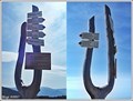
|   Mosaics of Coats of Arms of the Towns lying along Elbe River, Elbe spring, Czech Republic Mosaics of Coats of Arms of the Towns lying along Elbe River, Elbe spring, Czech Republic
in Mosaics The wall with mosaic emblems of the cities at the Elbe near the spring of the Elbe. posted by:  vraatja vraatja location: Královéhradecký kraj, Czechia date approved: 11/08/2010 last visited: 06/27/2021 |
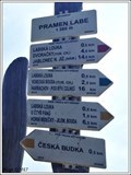
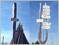
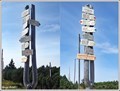
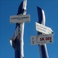
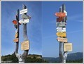
 view gallery view galleryE0 km |  Rozcestník turistických tras "Pramen Labe", Krkonoše, CZ Rozcestník turistických tras "Pramen Labe", Krkonoše, CZ
in Direction and Distance Arrows Rozcestník turistických tras "Pramen Labe"
EN: Direction and Distance Arrows of tourist paths "Source Elbe" posted by: Blogi location: Královéhradecký kraj, Czechia date approved: 06/09/2018 last visited: 06/27/2021 |
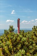
 view gallery view galleryE0 km |  1 380m - Pramen Labe, Krkonoše, CZ 1 380m - Pramen Labe, Krkonoše, CZ
in Elevation Signs Výška uvedená na rozcestníku "Pramen Labe"/Elevation Sign Elevation on crossroads "Source Elbe" posted by: Blogi location: Královéhradecký kraj, Czechia date approved: 02/04/2019 last visited: 08/18/2021 |
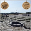
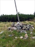
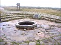 view gallery view gallery N0 km N0 km
|  Pramen Labe, Czech Republic Pramen Labe, Czech Republic
in Natural Springs Pramen naší nejvýznamnejší ceské reky Labe. posted by: Martani location: Královéhradecký kraj, Czechia date approved: 11/26/2008 last visited: 09/02/2020 |
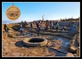
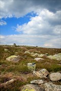
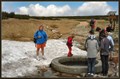 view gallery view galleryN0 km |  ORIGIN - Elbe (Labe), Giant Mountains (Krkonoše), Czech Republic ORIGIN - Elbe (Labe), Giant Mountains (Krkonoše), Czech Republic
in River Origins, Destinations and Confluences Main spring of Elbe (Labe) river called White Elbe (Bílé Labe) rises at an elevation of about 1,400 metres (4,593 ft) in the Giant Mountains (Krkonoše)on the north west borders of the Czech Republic. posted by: vraatja location: Královéhradecký kraj, Czechia date approved: 01/07/2011 last visited: 09/02/2020 |
 view gallery view galleryN0 km |  No.LS-01, Labska stezka - Pramen Labe, CZ No.LS-01, Labska stezka - Pramen Labe, CZ
in Tourist Stamps Photos Specialni edice Labska stezka-Pramen Labe,
EN/Special edition The Elbe Cycle Route-Source Elbe,
DE/Special Edition der Elberadweg-Quelle Elbe, posted by: Blogi location: Královéhradecký kraj, Czechia date approved: 04/04/2018 last visited: 09/02/2020 |
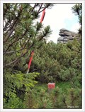
 view gallery view galleryN0 km | No. 1239, Pramen Labe - Krkonoše, CZ in Tourist Stamps Photos Symbolický pramen reky Labe na Labské louce v Krkonoších / Symbolic spring of Elbe river on Elbe meadow in Giant Mountains posted by: vraatja location: Královéhradecký kraj, Czechia date approved: 10/31/2011 last visited: 09/02/2020 |
 view gallery view gallery S0.5 km S0.5 km
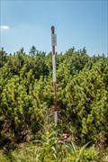
| Rozcestník turistických tras "Labská louka", Krkonoše, CZ in Direction and Distance Arrows Rozcestník turistických tras "Labská louka"./Direction and Distance Arrows of tourist trails "Labská louka". posted by: Blogi location: Liberecký kraj, Czechia date approved: 02/04/2019 last visited: 08/18/2021 |
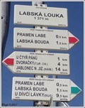 view gallery view galleryS0.5 km | 1 371m - Labská louka, Krkonoše, CZ in Elevation Signs Výška uvedená na rozcestníku "Labská louka"
/Elevation Sign on crossroads "Labská louka" posted by: Blogi location: Liberecký kraj, Czechia date approved: 02/04/2019 last visited: 08/18/2021 |
 view gallery view gallery W0.8 km W0.8 km
|  TB 0803-7 Sokolnik TB 0803-7 Sokolnik
in Czech Geodetic Points Trigonometrický bod na hrebenech Krkonoš posted by: alicek location: Liberecký kraj, Czechia date approved: 08/03/2015 last visited: never |
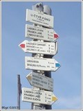
 view gallery view galleryS1.3 km | Rozcestník turistických tras "U Ctyr pánu", Krkonoše, CZ in Direction and Distance Arrows Rozcestník turistických tras "U Ctyr pánu"./Direction and Distance Arrows of tourist trails "U Ctyr pánu". posted by: Blogi location: Liberecký kraj, Czechia date approved: 02/12/2019 last visited: 08/18/2021 |
 view gallery view galleryS1.3 km | 1 339m - U Ctyr pánu - Pancavská louka, Krkonoše, CZ in Elevation Signs Výška uvedená na rozcestníku "U Ctyr pánu - Pancavská louka"
/Elevation Sign on crossroads "U Ctyr pánu - Pancavská louka" posted by: Blogi location: Liberecký kraj, Czechia date approved: 02/04/2019 last visited: 08/18/2021 |
 view gallery view galleryS1.3 km | TB 0803-13 Nad Pancavskou loukou in Czech Geodetic Points Trigonometrický bod na hrebenech Krkonoš posted by: alicek location: Liberecký kraj, Czechia date approved: 08/03/2015 last visited: 07/15/2016 |
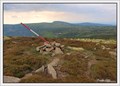 view gallery view galleryE1.3 km | TB 0803-8 U Snežných jam, CZ in Czech Geodetic Points Trigonometrický bod na hrebenech Krkonoš nedaleko Snežných jam. posted by: vraatja location: Královéhradecký kraj, Czechia date approved: 06/13/2011 last visited: 07/22/2017 |
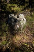
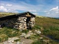 view gallery view galleryE1.6 km |  Kamenná studánka, Krkonoše, Czech Republic Kamenná studánka, Krkonoše, Czech Republic
in Spring Houses Spring with springhouse at the main ridge of the Giant Mountains. posted by: Arne1 location: Královéhradecký kraj, Czechia date approved: 07/24/2014 last visited: 07/08/2018 |
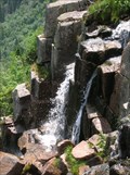 view gallery view galleryS1.8 km |  Pancava waterfall - Krkonose NP, Czech Republic Pancava waterfall - Krkonose NP, Czech Republic
in Waterfalls Pancava waterfall is highest waterfall in Czech Republic. posted by: AgentJ location: Královéhradecký kraj, Czechia date approved: 01/29/2009 last visited: 09/02/2020 |
 view gallery view galleryS2.3 km | 1367m - U Ruženciny zahrádky, Rokytnice nad Jizerou, CZ in Elevation Signs Výška uvedená na rozcestníku "U Ruženciny zahrádky" EN/Elevation Sign on crossroads "U Ruženciny zahrádky" posted by: ashberry location: Liberecký kraj, Czechia date approved: 05/19/2019 last visited: 08/18/2021 |
 view gallery view galleryE2.3 km | TB 0803-9 Vysoke kolo in Czech Geodetic Points Trigonometrický bod na hrebenech Krkonoš posted by: alicek location: Královéhradecký kraj, Czechia date approved: 08/03/2015 last visited: never |
 view gallery view gallery NW2.3 km NW2.3 km
| TB 0803-4 Svinské kameny, CZ in Czech Geodetic Points Trigonometrický po na cesko-polské hranici nedaleko skalních útvaru zvaných Svinské kameny (Trzy Swinki). posted by: vraatja location: Liberecký kraj, Czechia date approved: 06/13/2011 last visited: never |
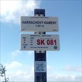 view gallery view galleryS2.4 km | 1421m - Harrachovy kameny, Rokytnice nad Jizerou, CZ in Elevation Signs Výška uvedená na rozcestníku "Harrachovy kameny" EN/Elevation Sign on crossroads "Harrachovy kameny" posted by: ashberry location: Liberecký kraj, Czechia date approved: 05/19/2019 last visited: 08/18/2021 |
 view gallery view galleryS2.6 km | 1 401m - Nad Kotelní jámou, Krkonoše, CZ in Elevation Signs Výška uvedená na rozcestníku "Nad Kotelní jámou"
/Elevation Sign on crossroads "Nad Kotelní jámou" posted by: Blogi location: Liberecký kraj, Czechia date approved: 02/04/2019 last visited: 08/18/2021 |
 view gallery view galleryS2.6 km | Rozcestník turistických tras "Nad Kotelní jámou", Krkonoše, CZ in Direction and Distance Arrows Rozcestník turistických tras "Nad Kotelní jámou"./Direction and Distance Arrows of tourist trails "Nad Kotelní jámou". posted by: Blogi location: Liberecký kraj, Czechia date approved: 02/04/2019 last visited: 08/18/2021 |
 view gallery view galleryS2.6 km | TB 0803-18 Kotel in Czech Geodetic Points Trigonometricky bod na hrebenech Krkonos posted by: alicek location: Liberecký kraj, Czechia date approved: 08/06/2011 last visited: never |
 view gallery view galleryW2.7 km | TB 0803-6 U Hranicniího potoka in Czech Geodetic Points Trigonometrický bod v Krkonoších posted by: alicek location: Královéhradecký kraj, Czechia date approved: 10/28/2021 last visited: never |
 view gallery view galleryS2.7 km | Rozcestník turistických tras "Vrbatova bouda", Krkonoše, CZ in Direction and Distance Arrows Rozcestník turistických tras "Vrbatova bouda"./Direction and Distance Arrows of tourist trails "Vrbatova bouda posted by: Blogi location: Královéhradecký kraj, Czechia date approved: 02/04/2019 last visited: 08/31/2020 |
|