 view gallery view gallery W0 km W0 km
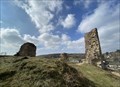
|   Burgruine Kronenburg, Dahlem, NRW, Germany Burgruine Kronenburg, Dahlem, NRW, Germany
in Castles Burgruine über dem Ort Kronenburg
Castle ruins above the village of Kronenburg posted by:  Tillba Tillba location: Nordrhein-Westfalen, Germany date approved: 09/27/2022 last visited: never |
 view gallery view gallery NW0.2 km NW0.2 km
|  Art*o*mat, Kronenburg, RLP, Germany Art*o*mat, Kronenburg, RLP, Germany
in Art*o*mats Souvenir Kunst im Kasten
Souvenir Art in the Box posted by: Tillba location: Nordrhein-Westfalen, Germany date approved: 10/04/2022 last visited: never |
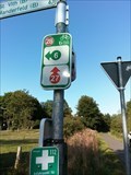
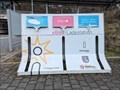
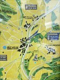
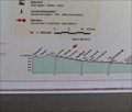 view gallery view galleryW2.3 km |  Kyllradweg, Hallschlag, Germany Kyllradweg, Hallschlag, Germany
in 'You Are Here' Maps Cycle through areas of outstanding beauty on a tour through the Eifel, such as the maars of the Volcanic Eifel, the Eifel National Park, the Ferschweiler high plateau or the Volcano Park in the volcanic East Eifel.
Travelling along disused railway lines and rivers, you can choose from a large number of family-friendly, easy cycle tours, while passionate sports enthusiasts will enjoy cycling uphill to the summits to be rewarded with fantastic views. posted by:  TeamYakara TeamYakara location: Rheinland-Pfalz, Germany date approved: 10/04/2019 last visited: never |
 view gallery view gallery SE3.7 km SE3.7 km
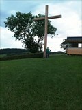
|  Friedenkreuz, Stadkyll, Germany Friedenkreuz, Stadkyll, Germany
in Christian Crosses Friedenkreuz/Peace Cross posted by: TeamYakara location: Rheinland-Pfalz, Germany date approved: 10/09/2019 last visited: never |
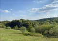
 view gallery view gallery SW6.4 km SW6.4 km
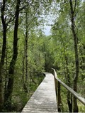
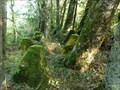
|  Bragphenn, Ormond, RLP, Germany Bragphenn, Ormond, RLP, Germany
in Non-Coastal Boardwalks Das Bragphenn ist ein Sattelregen-Hochmoor in der Nähe von Ormont
The Bragphenn is a saddle rain raised bog near Ormont posted by: Tillba location: Rheinland-Pfalz, Germany date approved: 10/16/2022 last visited: never |
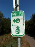
 view gallery view galleryW6.4 km |  28 - Losheim - DE 28 - Losheim - DE
in Cycling Routes Kyllradweg, Knotenpunkt 28, Am Goldenbach, Losheim posted by: TeamYakara location: Nordrhein-Westfalen, Germany date approved: 10/12/2019 last visited: never |
 view gallery view gallerySW6.6 km |  Bragphenn, Ormont, RLP, Germany Bragphenn, Ormont, RLP, Germany
in Hiking and walking trailheads Das Bragphenn ist ein Sattelregen-Hochmoor in der Nähe von Ormont
The Bragphenn is a saddle rain raised bog near Ormont posted by: Tillba location: Rheinland-Pfalz, Germany date approved: 10/04/2022 last visited: never |
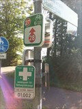 view gallery view galleryW6.8 km | 27 - Losheim - DE in Cycling Routes Kyllradweg, Knotenpunkt 27, Kyllradweg L45a, Losheim posted by: TeamYakara location: Nordrhein-Westfalen, Germany date approved: 10/12/2019 last visited: never |
 view gallery view galleryW6.8 km |  Siegfried Line- Dragon Teeth, Losheim, Germany Siegfried Line- Dragon Teeth, Losheim, Germany
in World War II Sites The "Siegfried Line", known in German as the Westwall, and to the Allies as the Dragons Teeth, was a German defensive line built during the 1930s opposite the French Maginot Line. posted by: TeamYakara location: Nordrhein-Westfalen, Germany date approved: 10/03/2019 last visited: never |
 view gallery view gallery E7.6 km E7.6 km
|  Railway Station - Jünkerath - Germany / Rhineland-Palatinate Railway Station - Jünkerath - Germany / Rhineland-Palatinate
in Electric Bike Charging Stations A public e-bike charging-station at the railway-station of Jünkerath posted by: ColleIsarco location: Rheinland-Pfalz, Germany date approved: 02/22/2024 last visited: never |
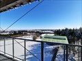 view gallery view galleryNW9 km |  Aussichtsturm "Am weissen Stein" - Hellenthal-Udenbreth, NRW, Germany Aussichtsturm "Am weissen Stein" - Hellenthal-Udenbreth, NRW, Germany
in Orientation Tables DE: Orientierungstafeln am Aussichtsturm "Am weissen Stein" im gleichnamigen Wintersportgebiet in der Eifel.
EN: Orientation boards at the observation tower "Am weissen Stein" in the winter sports area of the same name in the Eifel. posted by: FamilieFrohne location: Nordrhein-Westfalen, Germany date approved: 02/13/2021 last visited: never |
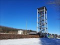 view gallery view galleryNW9 km |  Aussichtsturm "Am weissen Stein" - Hellenthal-Udenbreth, NRW, Germany Aussichtsturm "Am weissen Stein" - Hellenthal-Udenbreth, NRW, Germany
in Look-Out Towers DE: Der Aussichtsturm "Am weissen Stein" befindet sich im gleichnamigen Wintersportgebiet in der Eifel.
EN: The observation tower "Am weissen Stein" is located in the winter sports area of the same name in the Eifel. posted by: FamilieFrohne location: Nordrhein-Westfalen, Germany date approved: 02/13/2021 last visited: never |
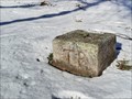 view gallery view galleryNW9 km |  TP - Parkplatz "Am weissen Stein" - Hellental-Udenbreth, NRW, Germany TP - Parkplatz "Am weissen Stein" - Hellental-Udenbreth, NRW, Germany
in German Trigonometric Points DE: Trigonometrischer Bodenpunkt in der Nähe des Parkplatzes "Am weissen Stein" in Hellenthal-Udenbreth.
EN: Trigonometric floor point near the parking lot "Am weissen Stein" in Hellenthal-Udenbreth. posted by: FamilieFrohne location: Nordrhein-Westfalen, Germany date approved: 02/13/2021 last visited: never |
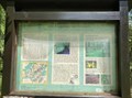
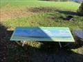
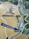
 view gallery view gallery S10.1 km S10.1 km
| Wanderparkplatz Nr. 16, 'Standort', Olzheim, RLP, Germany in 'You Are Here' Maps Wanderkarte am Wanderparkplatz in Olzheim
Hiking map at the hiking car park in Olzheim posted by: Tillba location: Rheinland-Pfalz, Germany date approved: 11/02/2022 last visited: never |
 view gallery view gallerySE10.1 km |  Vulkangarten, Steffeln, RLP, Grmany Vulkangarten, Steffeln, RLP, Grmany
in Municipal Parks and Plazas Vulkangarten - ein Blick in einen Vulkankrater
Volcano garden - a view into a volcano crater posted by: Tillba location: Rheinland-Pfalz, Germany date approved: 10/07/2022 last visited: never |
 view gallery view galleryW11.3 km | 26 - Buchholz - BE in Cycling Routes Ravel 45a, Buchholz, Liège, Belgium posted by: TeamYakara location: Liège, Belgium date approved: 10/12/2019 last visited: 02/27/2023 |
 view gallery view galleryS12.1 km | Eifelblick Duppach 'Auf Heilert', Duppach, RLP, Germany in Orientation Tables Eifelblick oberhalb von Duppach
Eifel view above Duppach posted by: Tillba location: Rheinland-Pfalz, Germany date approved: 11/13/2022 last visited: never |
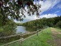 view gallery view galleryS12.4 km |  Stausee Wascheid, Gondenbrett-Wascheid, RLP, Germany Stausee Wascheid, Gondenbrett-Wascheid, RLP, Germany
in Water Dams Kleiner Stausee am Fuß der Schneifel
Small reservoir at the foot of the Schneifel posted by: Tillba location: Rheinland-Pfalz, Germany date approved: 10/05/2022 last visited: never |
 view gallery view galleryS12.4 km | Wandern und erholen (Wanderkarte), Wascheid, RLP, Germany in 'You Are Here' Maps Wanderkarte am Wascheider Stausee
Hiking map at the Wascheider Reservoir posted by: Tillba location: Rheinland-Pfalz, Germany date approved: 10/01/2022 last visited: never |
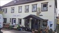 view gallery view gallery N12.6 km N12.6 km
|  Waldi's Eifel Antik - Kall, NRW, Germany Waldi's Eifel Antik - Kall, NRW, Germany
in Antique Shops Waldi's Eifel Antik in Kall. posted by: kaschper69 location: Nordrhein-Westfalen, Germany date approved: 04/23/2018 last visited: 04/09/2018 |
 view gallery view galleryN12.6 km |  Bericht "Trödelhalle in Krekel Horst Lichter kam zur Eröffnung von „Eifel Antik“ - Kall, NRW, Germany Bericht "Trödelhalle in Krekel Horst Lichter kam zur Eröffnung von „Eifel Antik“ - Kall, NRW, Germany
in News Article Locations Bericht "Trödelhalle in Krekel Horst Lichter kam zur Eröffnung von „Eifel Antik“ im Kölner Stadtanzeiger. posted by: kaschper69 location: Nordrhein-Westfalen, Germany date approved: 04/24/2018 last visited: 04/24/2018 |
 view gallery view gallerySE12.9 km |  Infopunkt Römische Villenanlage, Duppach, RLP, Germany Infopunkt Römische Villenanlage, Duppach, RLP, Germany
in Ancient Roman Civilization Eine Station der Straßen der Römer.
A stop on the roads of the Romans. posted by: Tillba location: Rheinland-Pfalz, Germany date approved: 10/12/2022 last visited: never |
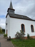 view gallery view galleryS13.2 km |  St. Jesu Namen, Gondenbrett-Wascheid, RLP, Germany St. Jesu Namen, Gondenbrett-Wascheid, RLP, Germany
in Deutsche Denkmallisten - German Monument Registers Kapelle in Wascheid Chapel in Wascheid posted by: Tillba location: Rheinland-Pfalz, Germany date approved: 10/17/2022 last visited: never |
 view gallery view galleryS13.2 km |  St. Jesu Namen, Wascheid, RLP, Germany St. Jesu Namen, Wascheid, RLP, Germany
in Roman Catholic Churches Kapelle in Wascheid
Chapel in Wascheid posted by: Tillba location: Rheinland-Pfalz, Germany date approved: 10/21/2022 last visited: never |
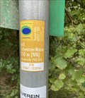 view gallery view gallerySW13.2 km |  Schwarzer Mann, Schneifel/ Wascheid, Germany - 550m (NN) Schwarzer Mann, Schneifel/ Wascheid, Germany - 550m (NN)
in Elevation Signs Höhenangabe Schwarzer Mann
Height indication Schwarzer Mann posted by: Tillba location: Rheinland-Pfalz, Germany date approved: 10/14/2022 last visited: never |
|