 view gallery view gallery SW9 km SW9 km
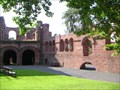
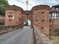
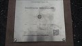
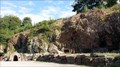
|   Kaiserpfalz Gelnhausen Kaiserpfalz Gelnhausen
in Castles Foundation and preferred abode of Emperor Frederick I. (called Barbarossa; 1122 - 1190). posted by:  thengel thengel location: Hessen, Germany date approved: 04/04/2010 last visited: 12/13/2017 |
 view gallery view gallery N11.3 km N11.3 km
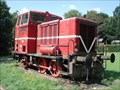
|  MaK diesel locomotive No. 220060, Birstein, DE MaK diesel locomotive No. 220060, Birstein, DE
in Locomotives MaK diesel locomotive No. 220060, Birstein, DE posted by:  Krxlvop Krxlvop location: Hessen, Germany date approved: 06/11/2016 last visited: 12/19/2017 |
 view gallery view gallery W13.2 km W13.2 km
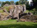
|  Der Wilde Stein, Büdingen - Hessen - Germany Der Wilde Stein, Büdingen - Hessen - Germany
in Places of Geologic Significance Wilder Stein, A Place of Geologic Significance nearly Büdingen posted by: jotheonly location: Hessen, Germany date approved: 02/05/2016 last visited: 05/02/2016 |
 view gallery view galleryW13.4 km |  Rathausstuhl, Büdingen, Germany Rathausstuhl, Büdingen, Germany
in Artistic Seating Südlich vor dem denkmalgeschützten Oberhof steht dieser große Stuhl aus Holz *** At the south of the building Oberhof you will find this big chair which does not fit into a usual residental house, but, you can sit on it (with help) posted by: 4spring location: Hessen, Germany date approved: 11/12/2016 last visited: 10/21/2016 |
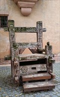 view gallery view galleryW13.4 km |  Rathausstuhl, Büdingen, Germany Rathausstuhl, Büdingen, Germany
in Outside Wooden Display Carvings Südlich vor dem denkmalgeschützten Oberhof steht dieser große Stuhl *** At the south of the building Oberhof you will find this big wooden chair with carvings posted by: 4spring location: Hessen, Germany date approved: 10/29/2016 last visited: 10/21/2016 |
 view gallery view galleryW13.5 km |  E-Bike-Ladestation am Marktplatz Büdingen, Büdingen, Hessen E-Bike-Ladestation am Marktplatz Büdingen, Büdingen, Hessen
in Electric Bike Charging Stations E-Bike-Ladestation am historischen Marktplatz in der Büdinger Altstadt - Chargingstation for electrical bicycles at the old market in the older part of Büdingen posted by: Windego1 location: Hessen, Germany date approved: 05/22/2023 last visited: 04/30/2022 |
 view gallery view galleryW13.5 km |  Untertor (Jerusalemer Tor), Büdingen, Germany Untertor (Jerusalemer Tor), Büdingen, Germany
in Wikipedia Entries Das Untertor, auch Jerusalemer Tor genannt, ist das Wahrzeichen der Stadt Büdingen ---- The Untertor, also called the Jerusalem Gate, is the landmark of the town of Büdingen posted by: Windego1 location: Hessen, Germany date approved: 07/16/2023 last visited: 08/21/2023 |
 view gallery view gallerySW14.2 km |  260 m ü. NN - Wetterschutzhütte Geiselbach — Geiselbach, Germany 260 m ü. NN - Wetterschutzhütte Geiselbach — Geiselbach, Germany
in Elevation Signs Altitude and UTM Coordinates at the signpost "Wetterschutzhütte Geiselbach" posted by: prussel location: Bayern, Germany date approved: 01/25/2023 last visited: never |
 view gallery view gallerySW14.2 km |  32U 514682 5553739 - Wetterschutzhütte Geiselbach — Geiselbach, Germany 32U 514682 5553739 - Wetterschutzhütte Geiselbach — Geiselbach, Germany
in Permanent Geographic Coordinates Altitude and UTM Coordinates at the signpost "Wetterschutzhütte Geiselbach" posted by: prussel location: Bayern, Germany date approved: 01/25/2023 last visited: never |
 view gallery view gallerySW14.5 km | 32U 514722 5553513 - Hangelstein Geiselbach — Geiselbach, Germany in Permanent Geographic Coordinates Altitude and UTM Coordinates at the signpost "Hangelstein Geiselbach" posted by: prussel location: Bayern, Germany date approved: 01/25/2023 last visited: never |
 view gallery view gallerySW14.5 km | 291 m ü. NN - Hangelstein Geiselbach — Geiselbach, Germany in Elevation Signs Altitude and UTM Coordinates at the signpost "Hangelstein Geiselbach" posted by: prussel location: Bayern, Germany date approved: 01/25/2023 last visited: never |
 view gallery view gallerySW14.6 km | 228 m ü. NN - Näßlichgrund Geiselbach — Geiselbach, Germany in Elevation Signs Altitude and UTM Coordinates at the signpost "Näßlichgrund Geiselbach" posted by: prussel location: Bayern, Germany date approved: 01/25/2023 last visited: never |
 view gallery view gallerySW14.6 km | 32U 513333 5553941 - Näßlichgrund Geiselbach — Geiselbach, Germany in Permanent Geographic Coordinates Altitude and UTM Coordinates at the signpost "Näßlichgrund Geiselbach" posted by: prussel location: Bayern, Germany date approved: 01/25/2023 last visited: never |
 view gallery view gallery S15.6 km S15.6 km
| Geodätischer Referenzpunkt Westerngrund, Bayern, Germany - N 50° 06.800 E 09° 15.150 in Permanent Geographic Coordinates Geodätischer Referenzpunkt Westerngrund
Die Koordinaten sind identisch mit den Koordinaten des EU-Mittelpunktes (Stand Mai 2014). posted by: datenhamster location: Bayern, Germany date approved: 08/24/2016 last visited: never |
 view gallery view galleryS15.6 km |  Mittelpunkt der EU - Westerngrund, Bayern, Germany Mittelpunkt der EU - Westerngrund, Bayern, Germany
in Geographical Centers Geographic centre of the European Union posted by: datenhamster location: Bayern, Germany date approved: 08/14/2016 last visited: never |
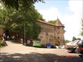 view gallery view galleryW16.6 km | Ronneburg Castle - Germany in Castles Medieval castle near the town of Neuwiedermuß, Hessen (Germany) posted by: =CCC= location: Hessen, Germany date approved: 05/26/2008 last visited: 11/17/2013 |
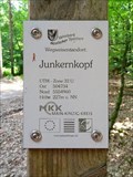 view gallery view gallerySW19.8 km | 32U 504734 5554960 — Junkernkopf - Rodenbach, Germany in Permanent Geographic Coordinates Altitude and UTM Coordinates at the signpost "Junkernkopf" near Rodenbach posted by: prussel location: Hessen, Germany date approved: 02/13/2019 last visited: never |
 view gallery view gallerySW19.8 km | 227m ü. NN - Junkernkopf — Rodenbach, Germany in Elevation Signs Altitude and UTM Coordinates at the signpost "Junkernkopf" near Rodenbach posted by: prussel location: Hessen, Germany date approved: 03/11/2019 last visited: never |
 view gallery view galleryS20.3 km |  Grube Wilhelmine - Kupferbergwerk Sommerkahl, Bayern, Germany Grube Wilhelmine - Kupferbergwerk Sommerkahl, Bayern, Germany
in Mines Old Copper Mine for Visitors posted by: datenhamster location: Bayern, Germany date approved: 08/15/2016 last visited: never |
 view gallery view gallery NW20.8 km NW20.8 km
|  Hessische Hoehenmessung - Alter Bahnhof Ortenberg, Hessen Hessische Hoehenmessung - Alter Bahnhof Ortenberg, Hessen
in German Benchmarks Altes/früheres Bahnhofsgebäude Ortenberg - Höhenmarke der Hessischen Höhenmessung --- Main building from the former trainstation of Ortenberg - Hoehenmarke of Hessian Department for Measuring posted by: Windego1 location: Hessen, Germany date approved: 06/12/2018 last visited: never |
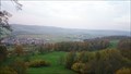 view gallery view galleryW21.2 km |  Glauburg-Aussicht, Glauberg, Hessen, Germany Glauburg-Aussicht, Glauberg, Hessen, Germany
in Scenic Overlooks Aussichtssteg auf der Glauburg bei Stockheim-Glauberg --- Lookout-Point at the Glauburg above Stockheim-Glauberg posted by: Windego1 location: Hessen, Germany date approved: 05/19/2023 last visited: never |
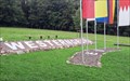
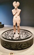
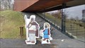 view gallery view galleryW21.2 km |  Keltenwelt, Glauberg, Germany Keltenwelt, Glauberg, Germany
in Photo Cutouts Vor dem Keltenmuseum kann man zum Kelten werden *** In front of the museum of the Celts you can pose like a Celt family posted by: 4spring location: Hessen, Germany date approved: 05/06/2016 last visited: 10/10/2020 |
 view gallery view galleryW21.2 km |  Keltenwelt am Glauberg - Glauburg, Germany Keltenwelt am Glauberg - Glauburg, Germany
in In Search of the Celts Museum mit der 2500 Jahre alten Statue eines Keltenfürsten, Funden aus drei Gräbern und einem rekonstruierten Hügelgrab *** Museum with the statue of a Celtic ruler, findings from three graves and the reconstruction of a burial mound posted by: 4spring location: Hessen, Germany date approved: 03/01/2015 last visited: 10/10/2020 |
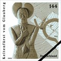 view gallery view galleryW21.2 km |  Keltenwelt am Glauberg, Glauburg, Germany Keltenwelt am Glauberg, Glauburg, Germany
in Philatelic Photographs Diese Sonderbriefmarke “Keltenfürst vom Glauberg” gibt es seit dem 3. Januar 2005 *** This postage stamp was issued on 3 January 2005 posted by: 4spring location: Hessen, Germany date approved: 05/05/2016 last visited: 10/10/2020 |
 view gallery view gallerySW21.4 km | 32U 506310 5550932 — Wanderheim Michelbach - Alzenau, Germany in Permanent Geographic Coordinates Altitude and UTM Coordinates at the signpost "Wanderheim Michelbach" near Alzenau posted by: prussel location: Bayern, Germany date approved: 02/13/2019 last visited: never |
|