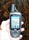
 view gallery view gallery E5.1 km E5.1 km
|   N50 E005 - Haut-Fays, Belgium N50 E005 - Haut-Fays, Belgium
in Confluence Spots An easy accessible Confluence Point in a forest near Haut-Fays, Belgium. posted by:  Hibje Hibje location: Namur, Belgium date approved: 11/23/2009 last visited: 04/07/2022 |
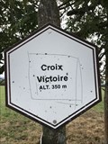 view gallery view gallery NE12.7 km NE12.7 km
|  Signe d'altitude du lieu Croix Victoire - Wellin - Belgique - 350 m Signe d'altitude du lieu Croix Victoire - Wellin - Belgique - 350 m
in Elevation Signs Signe d'altitude du lieu Croix Victoire posted by: franketmuriel location: Luxembourg, Belgium date approved: 08/15/2018 last visited: never |
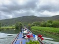
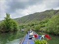 view gallery view gallery W14.8 km W14.8 km
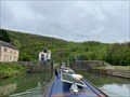
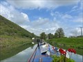
|  Écluse 54 - Fépin - Canal de la Meuse - Fépin - France Écluse 54 - Fépin - Canal de la Meuse - Fépin - France
in Waterway Locks, Planes and Lifts This is lock number 54 on the canal de la Meuse and is known as Fépin. posted by: ntpayne location: Grand-Est, France date approved: 07/19/2023 last visited: never |
 view gallery view galleryW15 km | Flood Gates (remnants) - Canal de la Meuse - Fépin - France in Waterway Locks, Planes and Lifts These flood gates can be found at the southern end of the lock cut near the village of Fépin. posted by: ntpayne location: Grand-Est, France date approved: 07/19/2023 last visited: never |
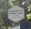
 view gallery view galleryE15.1 km | Passerelle de Chafté-Louis - Libin - Belgique, 260 m. in Elevation Signs [FR] Signal d'altitude près de la passerelle sur une des promenades entre les rivières Lesse et Lomme. [EN] Altitude signal near the bridge on one of the parkways between the Lesse and Lomme rivers. posted by: PaulLassiter location: Luxembourg, Belgium date approved: 07/16/2019 last visited: never |
 view gallery view galleryE15.1 km |  49° 59' 30,96" 05° 08' 39,89" - Passerelle de Chafté-Louis - Libin - Belgique 49° 59' 30,96" 05° 08' 39,89" - Passerelle de Chafté-Louis - Libin - Belgique
in Permanent Geographic Coordinates [FR] Coordonnées géographiques DMS se trouvant sur le panneau de randonnée. [EN] Geographical coordinates DMS located on the hiking sign. posted by: PaulLassiter location: Luxembourg, Belgium date approved: 07/16/2019 last visited: never |
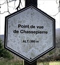 view gallery view galleryNE15.1 km | Point de vue de Chassepierre. Wellin, Belgique. 360 m. in Elevation Signs Signe d'altitude du Point de vue de Chassepierre. posted by: franketmuriel location: Luxembourg, Belgium date approved: 04/01/2020 last visited: never |
 view gallery view gallery N15.3 km N15.3 km
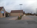
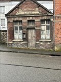
|  Aldi Store Beauraing Belgium Aldi Store Beauraing Belgium
in ALDI Stores Aldi Store Beauraing Belgium posted by: Alfredo4 location: Namur, Belgium date approved: 12/04/2011 last visited: 08/21/2017 |
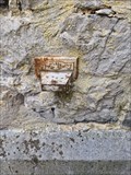 view gallery view galleryNE15.3 km |  NGI Meetpunt: Thi12 - Lomprez NGI Meetpunt: Thi12 - Lomprez
in Belgium Benchmarks A Belgium benchmark at the church in Lomprez posted by: kallehaugerne location: Luxembourg, Belgium date approved: 10/08/2023 last visited: never |
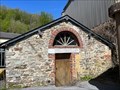
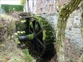 view gallery view galleryNE15.4 km |  Moulin de Lomprez - Lomprez, Belgium Moulin de Lomprez - Lomprez, Belgium
in Water Mills A Water Mill located at Vieille-Route 15 in Lomprez (Wellin), Belgium. The mill was initially built in the 12th century and was used for milling grain. It was also part of a defence line. It is restored in 1996. It is driven by a water wheel of 4m. posted by: Hibje location: Luxembourg, Belgium date approved: 11/24/2009 last visited: 08/14/2018 |
 view gallery view gallery NW16.1 km NW16.1 km
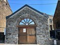
| ") Lavoir - Rue de Baty - Chooz - Ardennes 08 - France Lavoir - Rue de Baty - Chooz - Ardennes 08 - France
in Lavoir (wash houses) A lavoir on rue de Baty in Chooz in Ardennes 08, France. posted by: ntpayne location: Grand-Est, France date approved: 10/16/2020 last visited: never |
 view gallery view galleryNE16.3 km | Point de vue du Belvédère. Wellin, Belgique. 335 m. in Elevation Signs Signe d'altitude Point de vue du Belvédère. posted by: franketmuriel location: Luxembourg, Belgium date approved: 04/01/2020 last visited: never |
 view gallery view galleryW16.4 km | Écluse 52 - de la Roche de l'Uf - Canal de la Meuse - Fumay - France in Waterway Locks, Planes and Lifts This is lock number 52 on the canal de la Meuse and is known as de la Roche de l'Uf. posted by: ntpayne location: Grand-Est, France date approved: 07/17/2023 last visited: never |
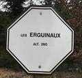 view gallery view galleryNE16.4 km | Les Erguinaux. Wellin, Belgique. 260 m. in Elevation Signs Signe d'altitude Les Erguinaux posted by: franketmuriel location: Luxembourg, Belgium date approved: 04/01/2020 last visited: never |
 view gallery view galleryNW16.4 km | Flood Gates (remnants) - Canal de la Meuse - Montigny-sur-Meuse - France in Waterway Locks, Planes and Lifts These flood gates can be found at the eastern side of the small village of Montigny-sur-Meuse. posted by: ntpayne location: Grand-Est, France date approved: 07/20/2023 last visited: never |
 view gallery view galleryW16.7 km | Lavoir - Rue Bauduin Petit - Fumay - Ardennes (08) - France in Lavoir (wash houses) A lavoir in Fumay, Ardennes (08), France. posted by: ntpayne location: Grand-Est, France date approved: 06/25/2023 last visited: never |
 view gallery view galleryW17.1 km | Écluse 53 - Vanne-Alcorps - Canal de la Meuse - Haybes - France in Waterway Locks, Planes and Lifts This is lock number 53 on the canal de la Meuse and is known as Vanne-Alcorps. posted by: ntpayne location: Grand-Est, France date approved: 07/19/2023 last visited: never |
 view gallery view galleryW17.1 km | Flood Gates (remnants) - Canal de la Meuse - Haybes - France in Waterway Locks, Planes and Lifts These flood gates can be found at the southern end of the lock cut near the small town of Haybes. posted by: ntpayne location: Grand-Est, France date approved: 07/19/2023 last visited: never |
 view gallery view gallery SW17.2 km SW17.2 km
| Lavoir - Rue du Docteur Ménard - Monthermé - Ardennes (08) - France in Lavoir (wash houses) A lavoir in Monthermé, Ardennes (08), France. posted by: ntpayne location: Grand-Est, France date approved: 06/27/2023 last visited: never |
 view gallery view galleryNW17.4 km | Écluse 55 - Montigny - Canal de la Meuse - Montigny-sur-Meuse - France in Waterway Locks, Planes and Lifts This is lock number 55 on the canal de la Meuse and is called Montigny. posted by: ntpayne location: Grand-Est, France date approved: 07/20/2023 last visited: never |
 view gallery view gallerySW17.5 km | Lavoir - Rue Jean Jaurès - Monthermé - Ardennes (08) - France in Lavoir (wash houses) A lavoir in Monthermé, Ardennes (08), France. posted by: ntpayne location: Grand-Est, France date approved: 06/27/2023 last visited: never |
 view gallery view galleryW17.7 km | Écluse 51 - Saint-Joseph - Canal de la Meuse - Fumay - France in Waterway Locks, Planes and Lifts This is lock number 51 on the canal de la Meuse and is known as Saint-Joseph. posted by: ntpayne location: Grand-Est, France date approved: 07/17/2023 last visited: never |
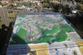 view gallery view galleryNW17.9 km |  Réserve naturelle nationale de la Pointe de Givet - Givet, Grand-Est, France Réserve naturelle nationale de la Pointe de Givet - Givet, Grand-Est, France
in 3D Map Models of Our World and Beyond Carte en relief de la Réserve naturelle nationale de la Pointe de Givet située au Mont d'Haurs à Givet. posted by: Waldog location: Grand-Est, France date approved: 10/14/2018 last visited: never |
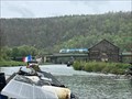
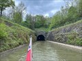 view gallery view galleryNW18.2 km |  Ham-sur-Meuse Canal Tunnel - North East Portal - Canal de la Meuse - Ham-sur-Meuse - Ardennes (08) - France Ham-sur-Meuse Canal Tunnel - North East Portal - Canal de la Meuse - Ham-sur-Meuse - Ardennes (08) - France
in Canal Tunnels The north east portal of the canal tunnel at Ham-sur-Meuse in Ardennes (08), France. posted by: ntpayne location: Grand-Est, France date approved: 05/24/2023 last visited: never |
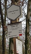 view gallery view gallery S18.2 km S18.2 km
| Crêtes de Frahan - Bouillon - Belgique, 227 m in Elevation Signs [FR] Signal d'altitude au pied des crêtes de Frahan. [EN] Altitude signal at the foot of the crests of Frahan. posted by: PaulLassiter location: Luxembourg, Belgium date approved: 12/05/2020 last visited: never |
|