 view gallery view gallery SW10.1 km SW10.1 km
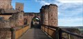
|   Henneburg - Stadtprozelten, Germany Henneburg - Stadtprozelten, Germany
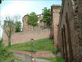
in Castles Die Henneburg ist eine staufische Höhenburg der Schenken von Limpurg am rechten Ufer des Mains in der Gemeinde Stadtprozelten im Landkreis Miltenberg in Bayern, Deutschland. posted by:  Maragul Maragul location: Bayern, Germany date approved: 11/10/2022 last visited: never |
 view gallery view gallery NW11.7 km NW11.7 km
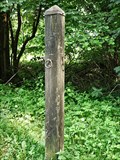
|  Echterspfahl — Weibersbrunn, Germany Echterspfahl — Weibersbrunn, Germany
in Wikipedia Entries The Echterspfahl is a prominent point on the ridge of the Spessart, a German low mountain range posted by: prussel location: Bayern, Germany date approved: 06/26/2012 last visited: 09/20/2013 |
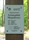 view gallery view galleryNW11.7 km |  480m ü. NN - Echterspfahl — Mespelbrunn, Germany 480m ü. NN - Echterspfahl — Mespelbrunn, Germany
in Elevation Signs Altitude and UTM Coordinates at the signpost "Echterspfahl Mespelbrunn" posted by: prussel location: Bayern, Germany date approved: 03/11/2019 last visited: never |
 view gallery view galleryNW11.7 km |  32U 524384 5529614 — Echterspfahl - Mespelbrunn, Germany 32U 524384 5529614 — Echterspfahl - Mespelbrunn, Germany
in Permanent Geographic Coordinates Altitude and UTM Coordinates at the signpost "Echterspfahl Mespelbrunn" posted by: prussel location: Bayern, Germany date approved: 02/13/2019 last visited: never |
 view gallery view gallery S12.1 km S12.1 km
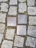
|  Stolpersteine Familie Häusler Stolpersteine Familie Häusler
in Stolpersteine Hier findet man die Stolpersteine von Babette, Gottlob und Friedrich Häusler. posted by: aendgraend location: Bayern, Germany date approved: 04/25/2018 last visited: never |
 view gallery view galleryS12.2 km | Burg Wertheim in Castles The Burg Wertheim (castle) is the landmark of the town of Wertheim in Germany. The town has a medieval town center with half-timbered houses and small streets. posted by: ossewa location: Baden-Württemberg, Germany date approved: 06/25/2013 last visited: 04/05/2018 |
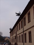
 view gallery view galleryNW12.4 km |  Wetterhexe - Hotel Spechtshaardt - Rothenbuch, Bavaria, Germany Wetterhexe - Hotel Spechtshaardt - Rothenbuch, Bavaria, Germany
in Unique Weathervanes Nice weather witch on the roof of the hotel "Spechtshaardt" in Rothenbuch. posted by: lumbricus location: Bayern, Germany date approved: 02/08/2017 last visited: never |
 view gallery view gallery W13.4 km W13.4 km
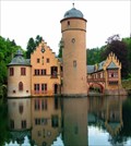
| Schloss Mespelbrunn in Castles Mespelbrunn Castle is a medieval moated castle on the territory of the town of Mespelbrunn, between Frankfurt and Würzburg, built in a remote tributary valley of th Spessart forest. It is one of the most visited water castles in Germany. posted by:  datenhamster datenhamster location: Bayern, Germany date approved: 03/27/2010 last visited: 05/29/2014 |
 view gallery view galleryW13.7 km |  O&K diesel locomotive No. 26621 in Heimbuchenthal, DE O&K diesel locomotive No. 26621 in Heimbuchenthal, DE
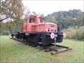
in Locomotives O&K diesel locomotive No. 26621 in Heimbuchenthal, DE posted by: Krxlvop location: Bayern, Germany date approved: 06/12/2016 last visited: 10/06/2013 |
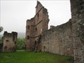 view gallery view gallerySW13.8 km | Collenburg - Dorfprozelten, Lk Miltenberg, Bayern, D in Wikipedia Entries Burgruine Collenburg am Main.
---
Castle ruine Collenburg at the river Main. posted by: lumbricus location: Bayern, Germany date approved: 10/22/2011 last visited: 11/21/2011 |
 view gallery view gallery NE15.8 km NE15.8 km
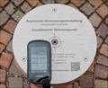
| 163,1 m ü.NN - Geodätischer Referenzpunkt — Lohr am Main, Germany in Elevation Signs Geodetic reference point determined by the Bayerische Vermessungsverwaltung (Bavarian Surveying Administration) showing the coordinates and a height of 163,1 m ü.NN posted by: prussel location: Bayern, Germany date approved: 06/27/2017 last visited: never |
 view gallery view galleryNE15.8 km | N 49° 59.7497' E 9° 34.4099' - Geodätischer Referenzpunkt — Lohr am Main, Germany in Permanent Geographic Coordinates Geodetic reference point determined by the Bayerische Vermessungsverwaltung (Bavarian Surveying Administration) posted by: prussel location: Bayern, Germany date approved: 06/29/2017 last visited: never |
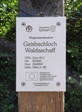 view gallery view galleryNW16.3 km | 248m ü. NN - Geisbachloch — Waldaschaff, Germany in Elevation Signs Altitude and UTM Coordinates at the signpost "Geisbachloch Waldaschaff" posted by: prussel location: Bayern, Germany date approved: 03/11/2019 last visited: never |
 view gallery view galleryNW16.3 km | 32U 521843 5533904 — Geisbachloch - Waldaschaff, Germany in Permanent Geographic Coordinates Altitude and UTM Coordinates at the signpost "Geisbachloch Waldaschaff" posted by: prussel location: Bayern, Germany date approved: 02/13/2019 last visited: never |
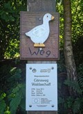 view gallery view galleryNW17.1 km | 262m ü. NN - Gänswewg — Waldaschaff, Germany in Elevation Signs Altitude and UTM Coordinates at the signpost "Gänsweg Waldaschaff" posted by: prussel location: Bayern, Germany date approved: 03/11/2019 last visited: never |
 view gallery view galleryNW17.1 km | 32U 521576 5534716 — Gänswewg - Waldaschaff, Germany in Permanent Geographic Coordinates Altitude and UTM Coordinates at the signpost "Gänsweg Waldaschaff" posted by: prussel location: Bayern, Germany date approved: 02/13/2019 last visited: never |
 view gallery view galleryW17.2 km | 397 m ü. NN - Hohe Wart Haus — Staatsforst Hohe Wart, Germany in Elevation Signs Altitude and UTM Coordinates at the signpost "Hohe Wart Haus". The "Hohe Wart" is wooded hill of the Spessart range, located in the unincorporated area "Forst Hohe Wart", between the districts of Aschaffenburg and Miltenberg posted by: prussel location: Bayern, Germany date approved: 06/15/2021 last visited: never |
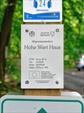 view gallery view galleryW17.2 km | 32U 518449 5529548 - Hohe Wart Haus — Staatsforst Hohe Wart, Germany in Permanent Geographic Coordinates Altitude and UTM Coordinates at the signpost "Hohe Wart Haus". The "Hohe Wart" is wooded hill of the Spessart range, located in the unincorporated area "Forst Hohe Wart", between the districts of Aschaffenburg and Miltenberg posted by: prussel location: Bayern, Germany date approved: 06/19/2021 last visited: never |
 view gallery view galleryS17.7 km |  Bronnbacher Wasserspeier Bronnbacher Wasserspeier
in Gargoyles and Chimeras - a large gargoyle in Bronnbach - ein mächtiger Wasserspeier in Bronnbach - posted by: Windego1 location: Baden-Württemberg, Germany date approved: 04/02/2013 last visited: never |
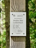 view gallery view galleryW17.7 km | 371 m ü. NN - Weißes Bild — Leidersbach, Germany in Elevation Signs Altitude and UTM Coordinates at the signpost "Weißes Bild Leidersbach" posted by: prussel location: Bayern, Germany date approved: 06/15/2021 last visited: never |
 view gallery view galleryW17.7 km | 32U 517833 5529352 - Weißes Bild — Leidersbach, Germany in Permanent Geographic Coordinates Altitude and UTM Coordinates at the signpost "Weißes Bild Leidersbach" posted by: prussel location: Bayern, Germany date approved: 06/19/2021 last visited: never |
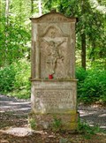 view gallery view galleryW17.7 km |  Weißes Bild — Leidersbach, Germany Weißes Bild — Leidersbach, Germany
in Deutsche Denkmallisten - German Monument Registers Baroque wayside shrine from 1762 in the forest near Leidersbach posted by: prussel location: Bayern, Germany date approved: 06/16/2021 last visited: never |
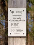 view gallery view galleryNW18.2 km | 369m ü. NN. - Abzweig Oberbessenbach — Bessenbach, Germany in Elevation Signs Altitude and UTM Coordinates at the signpost "Abzweig Oberbessenbach" near Bessenbach posted by: prussel location: Bayern, Germany date approved: 03/11/2019 last visited: never |
 view gallery view galleryNW18.2 km | 32U 519030 5533274 — Abzweig Oberbessenbach - Bessenbach, Germany in Permanent Geographic Coordinates Altitude and UTM Coordinates at the signpost "Abzweig Oberbessenbach" near Bessanbach posted by: prussel location: Bayern, Germany date approved: 02/13/2019 last visited: never |
 view gallery view galleryNW18.3 km | 383m ü. NN - Posthalterkreuz — Bessenbach, Germany in Elevation Signs Altitude and UTM Coordinates at the signpost "Posthalterkreuz" near Bessenbach posted by: prussel location: Bayern, Germany date approved: 03/11/2019 last visited: never |
|