 view gallery view gallery N2.9 km N2.9 km
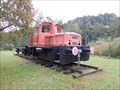
|   O&K diesel locomotive No. 26621 in Heimbuchenthal, DE O&K diesel locomotive No. 26621 in Heimbuchenthal, DE
in Locomotives O&K diesel locomotive No. 26621 in Heimbuchenthal, DE posted by:  Krxlvop Krxlvop location: Bayern, Germany date approved: 06/12/2016 last visited: 10/06/2013 |
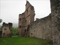
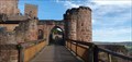
 view gallery view galleryN5.3 km |  Schloss Mespelbrunn Schloss Mespelbrunn
in Castles Mespelbrunn Castle is a medieval moated castle on the territory of the town of Mespelbrunn, between Frankfurt and Würzburg, built in a remote tributary valley of th Spessart forest. It is one of the most visited water castles in Germany. posted by: datenhamster location: Bayern, Germany date approved: 03/27/2010 last visited: 05/29/2014 |
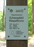 view gallery view galleryN7.1 km |  480m ü. NN - Echterspfahl — Mespelbrunn, Germany 480m ü. NN - Echterspfahl — Mespelbrunn, Germany
in Elevation Signs Altitude and UTM Coordinates at the signpost "Echterspfahl Mespelbrunn" posted by:  prussel prussel location: Bayern, Germany date approved: 03/11/2019 last visited: never |
 view gallery view galleryN7.1 km |  32U 524384 5529614 — Echterspfahl - Mespelbrunn, Germany 32U 524384 5529614 — Echterspfahl - Mespelbrunn, Germany
in Permanent Geographic Coordinates Altitude and UTM Coordinates at the signpost "Echterspfahl Mespelbrunn" posted by: prussel location: Bayern, Germany date approved: 02/13/2019 last visited: never |
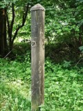 view gallery view galleryN7.1 km |  Echterspfahl — Weibersbrunn, Germany Echterspfahl — Weibersbrunn, Germany
in Wikipedia Entries The Echterspfahl is a prominent point on the ridge of the Spessart, a German low mountain range posted by: prussel location: Bayern, Germany date approved: 06/26/2012 last visited: 09/20/2013 |
 view gallery view gallery NW7.6 km NW7.6 km
| 397 m ü. NN - Hohe Wart Haus — Staatsforst Hohe Wart, Germany in Elevation Signs Altitude and UTM Coordinates at the signpost "Hohe Wart Haus". The "Hohe Wart" is wooded hill of the Spessart range, located in the unincorporated area "Forst Hohe Wart", between the districts of Aschaffenburg and Miltenberg posted by: prussel location: Bayern, Germany date approved: 06/15/2021 last visited: never |
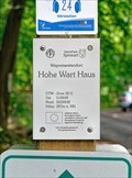 view gallery view galleryNW7.6 km | 32U 518449 5529548 - Hohe Wart Haus — Staatsforst Hohe Wart, Germany in Permanent Geographic Coordinates Altitude and UTM Coordinates at the signpost "Hohe Wart Haus". The "Hohe Wart" is wooded hill of the Spessart range, located in the unincorporated area "Forst Hohe Wart", between the districts of Aschaffenburg and Miltenberg posted by: prussel location: Bayern, Germany date approved: 06/19/2021 last visited: never |
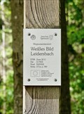 view gallery view galleryNW7.7 km | 371 m ü. NN - Weißes Bild — Leidersbach, Germany in Elevation Signs Altitude and UTM Coordinates at the signpost "Weißes Bild Leidersbach" posted by: prussel location: Bayern, Germany date approved: 06/15/2021 last visited: never |
 view gallery view galleryNW7.7 km | 32U 517833 5529352 - Weißes Bild — Leidersbach, Germany in Permanent Geographic Coordinates Altitude and UTM Coordinates at the signpost "Weißes Bild Leidersbach" posted by: prussel location: Bayern, Germany date approved: 06/19/2021 last visited: never |
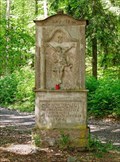 view gallery view galleryNW7.7 km |  Weißes Bild — Leidersbach, Germany Weißes Bild — Leidersbach, Germany
in Deutsche Denkmallisten - German Monument Registers Baroque wayside shrine from 1762 in the forest near Leidersbach posted by: prussel location: Bayern, Germany date approved: 06/16/2021 last visited: never |
 view gallery view galleryNW8.9 km | 321 m ü. NN - Antoniusbild Ebersbach — Leidersbach, Germany in Elevation Signs Altitude and UTM Coordinates at the signpost "Antoniusbild Ebersbach" posted by: prussel location: Bayern, Germany date approved: 06/15/2021 last visited: never |
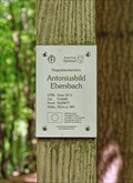 view gallery view galleryNW8.9 km | 32U 516684 5529877 - Antoniusbild Ebersbach — Leidersbach, Germany in Permanent Geographic Coordinates Altitude and UTM Coordinates at the signpost "Antoniusbild Ebersbach" posted by: prussel location: Bayern, Germany date approved: 06/19/2021 last visited: never |
 view gallery view galleryNW8.9 km |  Antoniusbildstock — Leidersbach, Germany Antoniusbildstock — Leidersbach, Germany
in Wayside shrines Wayside shrine of St. Anthony at a crossroads in the forest above Ebersbach, a district of the municipality of Leidersbach posted by: prussel location: Bayern, Germany date approved: 06/15/2021 last visited: never |
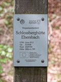 view gallery view galleryNW9.2 km | 302 m ü. NN - Schlossberghütte Ebersbach — Leidersbach, Germany in Elevation Signs Altitude and UTM Coordinates at the signpost "Schlossberghütte Ebersbach", at the shelter in the forest above Ebersbach posted by: prussel location: Bayern, Germany date approved: 06/15/2021 last visited: never |
 view gallery view galleryNW9.2 km | 32U 515938 5529754 - Schlossberghütte Ebersbach — Leidersbach, Germany in Permanent Geographic Coordinates Altitude and UTM Coordinates at the signpost "Schlossberghütte Ebersbach", at the shelter in the forest above Ebersbach posted by: prussel location: Bayern, Germany date approved: 06/19/2021 last visited: never |
 view gallery view gallery S10 km S10 km
| Collenburg - Dorfprozelten, Lk Miltenberg, Bayern, D in Wikipedia Entries Burgruine Collenburg am Main.
---
Castle ruine Collenburg at the river Main. posted by: lumbricus location: Bayern, Germany date approved: 10/22/2011 last visited: 11/21/2011 |
 view gallery view gallery W10.5 km W10.5 km
|  Eiscafe Lido - Elsenfeld, BY, Germany Eiscafe Lido - Elsenfeld, BY, Germany
in Ice Cream Parlors Little Ice Cream Parlor in Elsenfeld, Germany posted by: datenhamster location: Bayern, Germany date approved: 04/17/2010 last visited: 05/17/2015 |
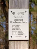 view gallery view galleryN10.8 km | 369m ü. NN. - Abzweig Oberbessenbach — Bessenbach, Germany in Elevation Signs Altitude and UTM Coordinates at the signpost "Abzweig Oberbessenbach" near Bessenbach posted by: prussel location: Bayern, Germany date approved: 03/11/2019 last visited: never |
 view gallery view galleryN10.8 km | 32U 519030 5533274 — Abzweig Oberbessenbach - Bessenbach, Germany in Permanent Geographic Coordinates Altitude and UTM Coordinates at the signpost "Abzweig Oberbessenbach" near Bessanbach posted by: prussel location: Bayern, Germany date approved: 02/13/2019 last visited: never |
 view gallery view gallery SE10.9 km SE10.9 km
| Henneburg - Stadtprozelten, Germany in Castles Die Henneburg ist eine staufische Höhenburg der Schenken von Limpurg am rechten Ufer des Mains in der Gemeinde Stadtprozelten im Landkreis Miltenberg in Bayern, Deutschland. posted by: Maragul location: Bayern, Germany date approved: 11/10/2022 last visited: never |
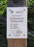 view gallery view galleryN10.9 km | 248m ü. NN - Geisbachloch — Waldaschaff, Germany in Elevation Signs Altitude and UTM Coordinates at the signpost "Geisbachloch Waldaschaff" posted by: prussel location: Bayern, Germany date approved: 03/11/2019 last visited: never |
 view gallery view galleryN10.9 km | 32U 521843 5533904 — Geisbachloch - Waldaschaff, Germany in Permanent Geographic Coordinates Altitude and UTM Coordinates at the signpost "Geisbachloch Waldaschaff" posted by: prussel location: Bayern, Germany date approved: 02/13/2019 last visited: never |
 view gallery view galleryN11.1 km | 383m ü. NN - Posthalterkreuz — Bessenbach, Germany in Elevation Signs Altitude and UTM Coordinates at the signpost "Posthalterkreuz" near Bessenbach posted by: prussel location: Bayern, Germany date approved: 03/11/2019 last visited: never |
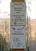 view gallery view galleryN11.1 km | 32U 519191 5533602 — Posthalterkreuz - Bessenbach, Germany in Permanent Geographic Coordinates Altitude and UTM Coordinates at the signpost "Posthalterkreuz" near Bessanbach posted by: prussel location: Bayern, Germany date approved: 02/13/2019 last visited: never |
 view gallery view gallery SW11.1 km SW11.1 km
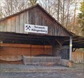
|  Tonwerk der Stadt Klingenberg am Main, Klingenberg, Germany Tonwerk der Stadt Klingenberg am Main, Klingenberg, Germany
in Mines Geschichte des Klingenberger Tonbergwerks:
Fast drei Jahrhunderte lieferte das Bergwerk in Klingenberg feinsten Ton, der einst in alle Erdteile exportiert wurde und damit Berühmtheit erlangte. posted by: Maragul location: Bayern, Germany date approved: 09/27/2022 last visited: never |
|