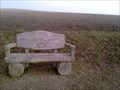
 view gallery view gallery NE6.9 km NE6.9 km
|   Bank am Jakobsweg - Neukirchen beim heiligen Blut, Bayern, Germany Bank am Jakobsweg - Neukirchen beim heiligen Blut, Bayern, Germany
in Way of St. James --- Bench at Neukirchen beim heiligen Blut (Eastern-Bavarian-Way of St. James) --- Bank am Ostbayrischen Jakobsweg bei Neukirchen beim heiligen Blut posted by:  Windego1 Windego1 location: Bayern, Germany date approved: 03/09/2014 last visited: never |
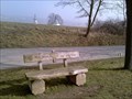 view gallery view galleryNE7.1 km | Zweite Bank am Jakobsweg - Neukirchen beim heiligen Blut, Bayern, Germany in Way of St. James --- Bench at Neukirchen beim heiligen Blut (Eastern-Bavarian-Way of St. James) --- Bank am Ostbayrischen Jakobsweg bei Neukirchen beim heiligen Blut posted by: Windego1 location: Bayern, Germany date approved: 03/11/2014 last visited: never |
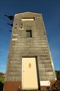 view gallery view gallery S10.1 km S10.1 km
|  Trafotower Bad Kötzting ( W.2 ) - BY / Germany Trafotower Bad Kötzting ( W.2 ) - BY / Germany
in Historic Transformer Sub-Stations Buildings Tower near road St2139 posted by: Iris & Harry location: Bayern, Germany date approved: 11/09/2016 last visited: never |
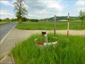
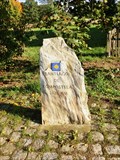 view gallery view galleryNE13.4 km | Way Marker - Eschlkam, Germany in Way of St. James Way Marker on Czech-Germany border. posted by: ToRo61 location: Bayern, Germany date approved: 10/06/2013 last visited: never |
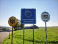 view gallery view galleryNE13.4 km |  Border Crossing Germany (Eschlkam) - Czech Republic (Vseruby) Border Crossing Germany (Eschlkam) - Czech Republic (Vseruby)
in Border Crossings This is the border crossing between Germany (Eschlkam) - Czech Republic (Vseruby). posted by: ToRo61 location: Bayern, Germany date approved: 10/08/2013 last visited: 06/16/2023 |
 view gallery view galleryNE13.7 km |  ZGS 32a_n VSER (Všeruby) ZGS 32a_n VSER (Všeruby)
in Czech Geodetic Points Bod základní geodynamické síte c. 32a VSER (Všeruby) posted by: rsc_cz location: Plzeňský kraj, Czechia date approved: 05/24/2015 last visited: 06/16/2023 |
 view gallery view gallery SE13.7 km SE13.7 km
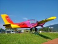
|  Morane Rallye - Flugplatz Arnbruck, BY, Germany Morane Rallye - Flugplatz Arnbruck, BY, Germany
in Static Aircraft Displays Static Aircraft Display Morane-Rallye - Flugplatz Arnbruck, BY, Germany posted by: jotheonly location: Bayern, Germany date approved: 09/19/2016 last visited: never |
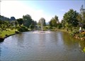
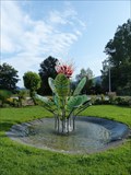 view gallery view gallerySE14.2 km |  Glasblumenbrunnen - Arnbruck, Lk Regen, Bavaria, Germany Glasblumenbrunnen - Arnbruck, Lk Regen, Bavaria, Germany
in Fountains Glasblumenbrunnen am Ortseingang von Arnbruck im Bayerischen Wald. --- Glas flower founatin near the town entry of Arnbruck in the Bavarian Forest. posted by: lumbricus location: Bayern, Germany date approved: 08/13/2014 last visited: 09/10/2016 |
 view gallery view gallerySE14.2 km | Springbrunnen im Glasdorf - Arnbruck, BY, Germany in Fountains Springbrunnen im Park des Glasdorfes.....
Fountain in the park of the glass village posted by: jotheonly location: Bayern, Germany date approved: 09/26/2016 last visited: 12/13/2016 |
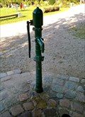 view gallery view gallerySE14.2 km |  Pumpe im Glasdorf - Arnbruck, BY, Germany Pumpe im Glasdorf - Arnbruck, BY, Germany
in Hand Operated Water Pumps Hand operated Waterpump in Arnbruck posted by: jotheonly location: Bayern, Germany date approved: 09/20/2016 last visited: never |
 view gallery view galleryNE14.3 km | TB 2802-1.0 Všeruby, kostel in Czech Geodetic Points Trigonometrický bod 2802-1.0 Všeruby, kostel. Bodem je stred makovice na veži rímskokatolického farního kostela sv. Michala ve Všerubech posted by: rsc_cz location: Plzeňský kraj, Czechia date approved: 12/28/2015 last visited: 06/16/2023 |
 view gallery view gallery N14.5 km N14.5 km
| TB 2811-5 U lesa in Czech Geodetic Points Trigonometrický bod na úbocí hory Cerchov posted by: pavlikVB location: Plzeňský kraj, Czechia date approved: 02/08/2012 last visited: never |
 view gallery view gallery NW14.5 km NW14.5 km
|  Drei Wappen - Nr 19., Bayern, DE, EU Drei Wappen - Nr 19., Bayern, DE, EU
in Public Land Survey Marks Historic Three Borders (Dreieckmark). The place where the borders meet. posted by: Arogant location: Bayern, Germany date approved: 10/13/2011 last visited: 09/06/2013 |
 view gallery view galleryNW14.5 km |  Drei Wappen, Bayern, DE, EU Drei Wappen, Bayern, DE, EU
in Tripoints and Multipoints Historic Three Borders (Dreieckmark). The place where the borders meet. posted by: Arogant location: Bayern, Germany date approved: 03/13/2012 last visited: 09/13/2013 |
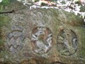 view gallery view galleryNW14.5 km |  Drei Wappen, Bayern, DE, EU Drei Wappen, Bayern, DE, EU
in European Historic Survey Stones, Monuments and Benchmarks Historic Three Borders (Dreieckmark). The place where the borders meet posted by: Arogant location: Bayern, Germany date approved: 10/12/2011 last visited: 09/13/2013 |
 view gallery view galleryNW14.5 km | DE - CZ, Drei Wappen, Bayern, DE, EU in Border Crossings CZ and DE border in mountain Czech forest. posted by: Arogant location: Bayern, Germany date approved: 10/12/2011 last visited: 09/13/2013 |
 view gallery view galleryNW14.6 km | TB 2811-6 U trí znaku (DO) in Czech Geodetic Points Triangulacní bod je na nejvyšším míste zalesnené kupy (907 mnm) poblíž Ceské státní hranice. posted by: Arogant location: Plzeňský kraj, Czechia date approved: 02/08/2012 last visited: never |
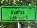 view gallery view galleryN14.8 km |  Bystrice - Fichtenbach, Ceský les, DO, CZ, EU Bystrice - Fichtenbach, Ceský les, DO, CZ, EU
in Ghost Towns Ghost village near Czech-Germany border. posted by: Arogant location: Plzeňský kraj, Czechia date approved: 10/19/2011 last visited: 08/03/2009 |
 view gallery view gallery W15.6 km W15.6 km
|  Bürgerhaus am Marktplatz - 93413 Cham/Deutschland/BY Bürgerhaus am Marktplatz - 93413 Cham/Deutschland/BY
in Deutsche Denkmallisten - German Monument Registers [D]Denkmalgeschütztes Bürgerhaus am Marktplatz Cham //
[EN] Historic-protected Mansionhouse in Cham posted by: *Team Krombaer* location: Bayern, Germany date approved: 11/08/2016 last visited: 06/16/2023 |
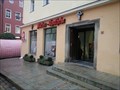 view gallery view galleryW15.6 km |  Marien-Apotheke - Cham/Germany/BY Marien-Apotheke - Cham/Germany/BY
in Independent Pharmacies Independent pharmacy in Cham, Germany posted by: *Team Krombaer* location: Bayern, Germany date approved: 11/08/2016 last visited: 06/16/2023 |
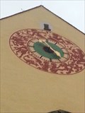 view gallery view galleryW15.6 km |  Signs of zodiac - Clock of the townhall - 93416 Cham/BY/Germany Signs of zodiac - Clock of the townhall - 93416 Cham/BY/Germany
in Signs of Zodiac In a height abbot 10 meters is that townclock with signs of zodiac posted by: *Team Krombaer* location: Bayern, Germany date approved: 11/07/2016 last visited: 06/16/2023 |
 view gallery view galleryN15.8 km |  No.1016, Ceska studanka - Cerchov, CZ No.1016, Ceska studanka - Cerchov, CZ
in Tourist Stamps Photos CS: Ceská studánka je silný pramen vyverající na úbocí hory Cerchov ve výšce 730m n.m. / EN: Bohemain spring is the abundant source on the mountainside of the mountain Cerchov at an altitude of 730 meters. posted by: pavlikVB location: Plzeňský kraj, Czechia date approved: 02/09/2012 last visited: 08/20/2022 |
 view gallery view galleryW15.8 km |  Elektrizitätswerk - Classic German Game - Cham/Germany/BY Elektrizitätswerk - Classic German Game - Cham/Germany/BY
in Monopoly in the Real World The historic-protected Electricity Plant in Cham, Germany posted by: *Team Krombaer* location: Bayern, Germany date approved: 11/08/2016 last visited: never |
 view gallery view galleryW15.8 km | Turbinenhaus der Stadtwerke - 93413 Cham/Deutschland/BY in Deutsche Denkmallisten - German Monument Registers [D] Turbinenhaus des Städtischen Elektrizitätswerks [EN] Historic-protected power-plant house in the city of Cham posted by: *Team Krombaer* location: Bayern, Germany date approved: 11/08/2016 last visited: never |
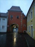 view gallery view galleryW15.9 km |  Biertor - 93413 Cham /BY/Deutschland Biertor - 93413 Cham /BY/Deutschland
in Satellite Imagery Oddities So-called "Biertor" in Cham, Germany posted by: *Team Krombaer* location: Bayern, Germany date approved: 02/19/2017 last visited: never |
|