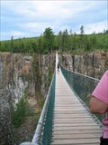
 view gallery view gallery SE54.9 km SE54.9 km
|   Eagle Canyon Eagle Canyon
in Pedestrian Suspension Bridges The longest footbridge in Canada! posted by:  HendieD HendieD location: Ontario, Canada date approved: 03/02/2007 last visited: 02/29/2020 |
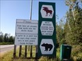
 view gallery view gallery SW63.6 km SW63.6 km
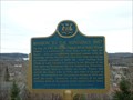
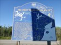
|  "THE ARCTIC WATERSHED" - Hwy 17 Raith, ON "THE ARCTIC WATERSHED" - Hwy 17 Raith, ON
in Ontario Provincial Plaques Ontario Provincial Plaque located at the division of the Arctic and Atlantic Watersheds in Northern Ontario, just south of the village of Raith. posted by: jiggs11 location: Ontario, Canada date approved: 09/14/2020 last visited: 06/01/2023 |
 view gallery view gallerySW63.6 km |  Arctic Ocean/Atlantic Ocean Watersheds - Hwy 17 ON Arctic Ocean/Atlantic Ocean Watersheds - Hwy 17 ON
in Watershed Markers and Monuments Two-sided marker on the Trans Canada Highway defining the Arctic Ocean and Atlantic Ocean Watersheds, located on the Trans Canada Highway about 30 miles north of Kakabeka Falls, ON posted by: jiggs11 location: Ontario, Canada date approved: 09/15/2020 last visited: 06/01/2023 |
 view gallery view gallery E63.7 km E63.7 km
|  Nipigon Nylons - Nipigon, ON Nipigon Nylons - Nipigon, ON
in Photo Cutouts Large cut-out board located near the entrance to the Nipigon and Area Travel Information Centre. posted by: jiggs11 location: Ontario, Canada date approved: 09/17/2020 last visited: never |
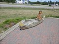 view gallery view galleryE63.7 km |  Ojibwe and Canoe - Nipigon, ON Ojibwe and Canoe - Nipigon, ON
in Outside Wooden Display Carvings Nice carved piece depicting an Ojibwe in a canoe, located outside the Nipigon Tourist Information Centre. posted by: jiggs11 location: Ontario, Canada date approved: 09/10/2020 last visited: never |
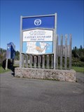
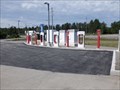 view gallery view galleryE63.7 km |  Tesla Charging Station - Nipigon, ON Tesla Charging Station - Nipigon, ON
in Electric Car Charging Stations Nulti-bay Tesla Charging Station located at the Nipigon Tourist Information Centre off the Trans Canada Highway west of Nipigon, ON posted by: jiggs11 location: Ontario, Canada date approved: 09/10/2020 last visited: never |
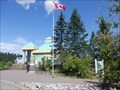 view gallery view galleryE63.7 km |  Nipigon & Area Travel Information Centre - Nipigon, ON Nipigon & Area Travel Information Centre - Nipigon, ON
in Tourist Information Centers - Visitor Centers Modern, well-stocked Tourist Information Centre located on the western outskirts of Nipigon, ON. posted by: jiggs11 location: Ontario, Canada date approved: 09/11/2020 last visited: never |
 view gallery view galleryE66.5 km | "MISSION TO THE NIPISSINGS 1667" - Nipigon in Ontario Provincial Plaques Commemorates the first Mass celebrated west of Sault Ste. Marie, Ontario. posted by: Pouchie location: Ontario, Canada date approved: 11/09/2006 last visited: 08/18/2009 |
 view gallery view gallery W66.6 km W66.6 km
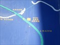
|  You Are Here - First Trans Canada Route - Hwy 17, Raith ON You Are Here - First Trans Canada Route - Hwy 17, Raith ON
in 'You Are Here' Maps You Are Here on a large map of Northern Ontario at the Eastern/Central Time dividing point on the Trans Canada Highway. posted by: jiggs11 location: Ontario, Canada date approved: 09/15/2020 last visited: 09/26/2022 |
 view gallery view galleryW66.6 km |  90 Degrees West - Eastern/Central Time Zone - Trans Canada Highway 17 - Argon, ON 90 Degrees West - Eastern/Central Time Zone - Trans Canada Highway 17 - Argon, ON
in Permanent Geographic Coordinates Large Marker indicating the line between the Eastern and Central Time Zones. posted by: jiggs11 location: Ontario, Canada date approved: 09/17/2020 last visited: 09/26/2022 |
 view gallery view galleryW66.6 km |  The First Trans-Canada Route - Raith, ON The First Trans-Canada Route - Raith, ON
in Signs of History Large marker indicating the history of the first water routes to the west through northern Ontario posted by: jiggs11 location: Ontario, Canada date approved: 09/15/2020 last visited: 09/26/2022 |
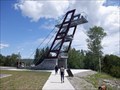 view gallery view galleryE67.3 km |  Bridgeview Lookout Tower - Nipigon, ON Bridgeview Lookout Tower - Nipigon, ON
in Look-Out Towers Multi-level metal lookout point offering spectacular views of the Nipigon River, suspension bridge, rail lines and the north shore of Lake Superior. posted by: jiggs11 location: Ontario, Canada date approved: 09/10/2020 last visited: 06/20/2023 |
 view gallery view galleryE67.8 km |  Nipigon River Bridge - Nipigon, ON Nipigon River Bridge - Nipigon, ON
in Suspension Bridges Cable-stayed suspension bridge crossing the Nipigon River on the Trans Canada Highway east of Nipigon, ON. posted by: jiggs11 location: Ontario, Canada date approved: 09/10/2020 last visited: 06/20/2023 |
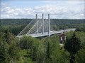 view gallery view galleryE67.8 km |  Nipigon River Bridge - Nipigon, ON Nipigon River Bridge - Nipigon, ON
in Wikipedia Entries Modern cable-stayed suspension bridge crossing the Nipigon River on the Trans Canada Highway east of Nipigon, ON. posted by: jiggs11 location: Ontario, Canada date approved: 09/10/2020 last visited: 11/22/2022 |
 view gallery view gallery S68.6 km S68.6 km
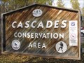
|  Cascades Conservation Area - Thunder Bay, Ontario Cascades Conservation Area - Thunder Bay, Ontario
in Public Access Lands Cascades Conservation Area is a nice place for a quiet hike in a beautiful poplar and birch forest. posted by: PM8 location: Ontario, Canada date approved: 10/19/2014 last visited: 09/10/2022 |
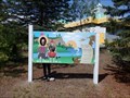
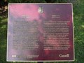 view gallery view galleryS69.4 km |  CNHS Terry Fox (1958-1981) - Thunder Bay ON CNHS Terry Fox (1958-1981) - Thunder Bay ON
in Canadian National Historic Sites This CNHS person is Terry Fox (1958-1981). This plaque is at the Terry Fox Scenic Lookout, on Highway 11/17, 1.1 km east of Hodder Avenue (7.5 km east of the intersection of Highway 102) near Thunder Bay, Ontario. posted by: PeterNoG location: Ontario, Canada date approved: 07/20/2012 last visited: 07/01/2016 |
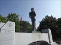 view gallery view galleryS69.4 km |  Terry Fox Statue - Thunder Bay ON Terry Fox Statue - Thunder Bay ON
in Statues of Historic Figures This Statue of an Historic Figure is at the Terry Fox Scenic Lookout on Highway 11/17, 7.5 km east of its intersection with Highway 102, on the east side of Thunder Bay, Ontario. posted by: PeterNoG location: Ontario, Canada date approved: 12/20/2012 last visited: 07/01/2016 |
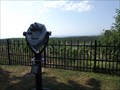 view gallery view galleryS69.4 km |  Bino - Terry Fox Lookout - Thunder Bay ON Bino - Terry Fox Lookout - Thunder Bay ON
in Coin-Op Binoculars These Binoculars are at the Terry Fox Scenic Lookout on Highway 11/17, 1 km (.6 miles) east of Hodder Ave, on the east side of Thunder Bay, Ontario. posted by: PeterNoG location: Ontario, Canada date approved: 12/20/2012 last visited: 09/10/2022 |
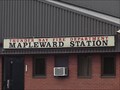 view gallery view galleryS72.4 km |  Thunder Bay Fire Department Mapleward Station Thunder Bay Fire Department Mapleward Station
in Firehouses This Firehouse is on Government Road at Mapleward Road about 8km west Highway 61 in the northwestern area of Thunder Bay, Ontario. posted by: PeterNoG location: Ontario, Canada date approved: 07/22/2012 last visited: 02/29/2020 |
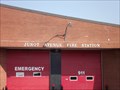 view gallery view galleryS73.7 km | Junot Avenue Fire Station in Firehouses This Firehouse is on Junot Street North just east of Red River Road in Thunder Bay, Ontario. posted by: PeterNoG location: Ontario, Canada date approved: 07/22/2012 last visited: 02/29/2020 |
 view gallery view galleryS73.9 km |  TransCanada McDonalds - Thunder Bay TransCanada McDonalds - Thunder Bay
in McDonald's Restaurants Located just off the TransCanada in Thunder Bay. posted by:  ibycus ibycus location: Ontario, Canada date approved: 08/16/2005 last visited: 02/29/2020 |
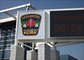 view gallery view galleryS74 km |  Superior North EMS Time & Temperature - Thunder Bay ON Superior North EMS Time & Temperature - Thunder Bay ON
in Time and Temperature Signs This Time and Temperature Sign is at the Superior North EMS District Headquarters on South Junot Avenue between Windsor Street and Walkover Street in Thunder Bay, Ontario. posted by: PeterNoG location: Ontario, Canada date approved: 07/25/2012 last visited: 02/29/2020 |
 view gallery view galleryS74 km |  Superior North EMS - Thunder Bay ON Superior North EMS - Thunder Bay ON
in Paramedic Stations This is North Paramedic Station, on South Junot Avenue between Windsor Street and Walkover Street, in Thunder Bay, Ontario. posted by: PeterNoG location: Ontario, Canada date approved: 07/25/2012 last visited: 02/29/2020 |
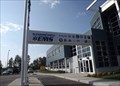
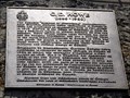 view gallery view galleryS74.5 km | CNHS C.D. Howe (1886-1960) - Thunder Bay ON in Canadian National Historic Sites This CNHS person is C.D. Howe. The plaque is in a nice parking area overlooking the harbour on Marina Park Drive near the Marina Park Overpass in Thunder Bay, Ontario. posted by: PeterNoG location: Ontario, Canada date approved: 07/20/2012 last visited: 02/29/2020 |
 E74.5 km |  CLSx2 - MISSING CLSx2 - MISSING
in Bloggers A short description of each cache we go on and what happened along the way posted by: CLSx2 location: Wisconsin date approved: 06/26/2006 last visited: 12/12/2022 |
|