 view gallery view gallery W7.1 km W7.1 km
|   Mulberry Whale, St Denis de Méré, Normandie, FR Mulberry Whale, St Denis de Méré, Normandie, FR
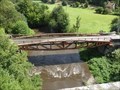
in World War II Sites This bridge "Le Pont des Bordeaux" over the Noireau near St Denis de Méré once formed part of the temporary "Mulberry" harbour at Arromanches. The original bridge was destroyed by the French Resistance shortly after D-Day. posted by:  Team Sieni Team Sieni location: Normandie, France date approved: 09/13/2013 last visited: 03/18/2021 |
 view gallery view gallery E12.7 km E12.7 km
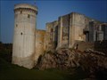
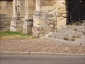
|  Le château de Falaise - Falaise, France Le château de Falaise - Falaise, France
in Monuments Historiques Français FR - château Guillaume-le-Conquérant est un château fort formé d'une enceinte, situé sur un éperon rocheux.
EN - The castle Guillaume-le-Conquérant is a fortified castle formed by an enclosure, located on a rocky spur. posted by:  geotrouvtou59 geotrouvtou59 location: Normandie, France date approved: 04/05/2020 last visited: 03/18/2021 |
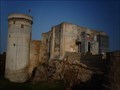
 view gallery view galleryE12.7 km |  Le château de Falaise - Falaise, France Le château de Falaise - Falaise, France
in Wikipedia Entries FR - château Guillaume-le-Conquérant est un château fort formé d'une enceinte, situé sur un éperon rocheux.
EN - The castle Guillaume-le-Conquérant is a fortified castle formed by an enclosure, located on a rocky spur. posted by: geotrouvtou59 location: Normandie, France date approved: 04/05/2020 last visited: 03/18/2021 |
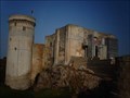
 view gallery view galleryE12.7 km |  Le château de Falaise - Falaise, France Le château de Falaise - Falaise, France
in Castles FR - château Guillaume-le-Conquérant est un château fort formé d'une enceinte, situé sur un éperon rocheux.
EN - The castle Guillaume-le-Conquérant is a fortified castle formed by an enclosure, located on a rocky spur. posted by: geotrouvtou59 location: Normandie, France date approved: 04/10/2020 last visited: 03/18/2021 |
 view gallery view galleryE12.7 km |  Le château de Falaise - Falaise, France Le château de Falaise - Falaise, France
in Satellite Imagery Oddities FR - château Guillaume-le-Conquérant est un château fort formé d'une enceinte, situé sur un éperon rocheux.
EN - The castle Guillaume-le-Conquérant is a fortified castle formed by an enclosure, located on a rocky spur. posted by: geotrouvtou59 location: Normandie, France date approved: 04/23/2020 last visited: 03/18/2021 |
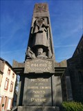
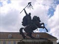 view gallery view galleryE12.9 km |  Guillaume le Conquerant. Falaise. France Guillaume le Conquerant. Falaise. France
in Monarchs of the World Statue de Guillaume le Conquerant posted by: lulu_et_compagnie location: Normandie, France date approved: 10/14/2015 last visited: 03/18/2021 |
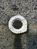
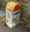 view gallery view galleryW13 km |  Borne Kilometrique, Condé-sur-Noireau, France Borne Kilometrique, Condé-sur-Noireau, France
in Milestones A typical French Borne Kilometrique, in Condé-sur-Noireau posted by: Team Sieni location: Normandie, France date approved: 09/14/2013 last visited: 06/16/2016 |
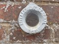
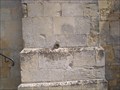
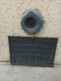
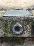
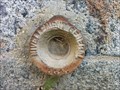
 view gallery view galleryE13 km |  benchmarks Eglise de Falaise benchmarks Eglise de Falaise
in French Benchmarks Sur l'église posted by: lulu_et_compagnie location: Normandie, France date approved: 08/20/2013 last visited: 03/09/2019 |
 view gallery view gallery NE13.5 km NE13.5 km
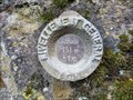
| Repère de Nivellement du bureau des Mines de Soumont in French Benchmarks Repère de nivellement situé sur l'ancienne propriété des Mines de Soumont. posted by: junkys location: Île-de-France, France date approved: 08/17/2017 last visited: 02/23/2019 |
 view gallery view galleryE13.8 km | Benchmarks N-D de Guibray à Falaise in French Benchmarks Sur l'église posted by: lulu_et_compagnie location: Normandie, France date approved: 08/20/2013 last visited: 06/17/2015 |
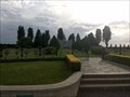 view gallery view galleryNE16.6 km |  Cimetière Militaire Polonais - Urville - France Cimetière Militaire Polonais - Urville - France
in Veteran Cemeteries Au bord de la RN158, à vingt kilomètres au Sud de Caen, le cimetière d’Urville est la dernière demeure de 696 combattants.
At the edge of the RN158, twenty kilometers south of Caen, the cemetery of Urville is the last residence of 696 fighters. posted by: Alfouine location: Normandie, France date approved: 09/06/2017 last visited: 02/23/2019 |
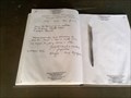 view gallery view galleryNE16.6 km |  Cimetière Militaire Polonais - Urville - France Cimetière Militaire Polonais - Urville - France
in Guest Books Livre d'or du cimetière Polonais d'Urville dans un magnifique emplacement chargé de symboles.
Guestbook of the Polish cemetery of Urville in a magnificent site loaded with symbols. posted by: Alfouine location: Normandie, France date approved: 09/05/2017 last visited: 02/23/2019 |
 view gallery view galleryNE16.6 km |  Cimetière Militaire Polonais - Urville - France Cimetière Militaire Polonais - Urville - France
in Outdoor Altars Un autel pour célébrées des messes au milieu des soldats polonais catholiques morts pour la paix durant la seconde guerre mondiale.
An altar to celebrate masses among Polish Catholic soldiers who died for peace during the Second World War. posted by: Alfouine location: Normandie, France date approved: 09/10/2017 last visited: 11/06/2021 |
 view gallery view gallery SW20.8 km SW20.8 km
| Eglise Saint Jean, Benchmark - Flers, France in French Benchmarks Repère de nivellement sur l'église St Jean à Flers, Orne. posted by: AlexEmilie location: Normandie, France date approved: 11/01/2016 last visited: never |
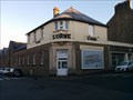 view gallery view gallerySW21.2 km |  Siège L'Orne combattante - Flers, France Siège L'Orne combattante - Flers, France
in Newspaper Headquarters Siège du journal hebdomadaire de L'orne Combattante à Flers.
Headquarters of the weekly newspaper L'Orne Combattante in Flers. posted by: AlexEmilie location: Normandie, France date approved: 02/07/2017 last visited: 03/26/2021 |
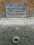
 view gallery view gallerySW21.2 km | Rue de la Boule, Benchmark - Flers, France in French Benchmarks Repère de nivellement rue de la Boule à Flers, Orne. posted by: AlexEmilie location: Normandie, France date approved: 10/27/2016 last visited: never |
 view gallery view gallerySW21.2 km | Square Delaunay, Benchmark - Flers, France in French Benchmarks Repère de nivellement sur le soubassement d'un bâtiment, face au square Delaunay à Flers, Orne. posted by: AlexEmilie location: Normandie, France date approved: 10/27/2016 last visited: never |
 view gallery view gallerySW21.2 km | Eglise St Germain, Benchmark - Flers, France in French Benchmarks Repère de nivellement sur l'église St Germain à Flers, Orne. posted by: AlexEmilie location: Normandie, France date approved: 10/27/2016 last visited: never |
 view gallery view gallerySW21.4 km | Marché couvert, Benchmark - Flers, France in French Benchmarks Repère de nivellement sur le mur du marché couvert, centre ville de Flers, Orne. posted by: AlexEmilie location: Normandie, France date approved: 10/27/2016 last visited: never |
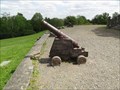 view gallery view gallerySW21.9 km |  Les canons du mont de Cerisy - France Les canons du mont de Cerisy - France
in Static Artillery Displays Canons au pied du fort du Mont de Cerisy, dans la commune de Cerisy-Belle-Etoile, dans l'Orne. posted by: AlexEmilie location: Normandie, France date approved: 07/04/2016 last visited: 03/26/2021 |
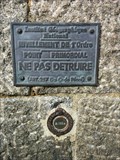
 view gallery view gallerySW21.9 km |  Table d'orientation du mont de Cerisy - Orne, France Table d'orientation du mont de Cerisy - Orne, France
in Orientation Tables Table d'orientation du mont de Cerisy.
Orientation table of Mount Cerisy. posted by: AlexEmilie location: Normandie, France date approved: 07/06/2016 last visited: 03/26/2021 |
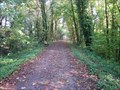 view gallery view gallerySW22.7 km |  Voie Verte Flers-Domfront - Orne, France Voie Verte Flers-Domfront - Orne, France
in Rails to Trails Voie verte entre Flers et Domfront dans l'Orne.
Greenway between Flers and Domfront in the Orne. posted by: AlexEmilie location: Normandie, France date approved: 02/08/2017 last visited: 03/27/2021 |
 view gallery view gallery NW23.2 km NW23.2 km
| Benchmark - Grotte de Marie - Banneville-sur-Ajon (Calvados), France in French Benchmarks Repère de nivellement de la grotte de Banneville-sur-Ajon posted by: junkys location: Normandie, France date approved: 11/13/2018 last visited: 12/04/2019 |
 view gallery view gallerySW23.3 km | Eglise de Messei Benchmark, mur - Messei, France in French Benchmarks Repère de nivellement sur le mur de l'église de Messei, dans l'Orne. posted by: AlexEmilie location: Normandie, France date approved: 10/08/2016 last visited: never |
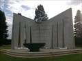
 view gallery view gallerySW23.3 km |  World War I - Messei, France World War I - Messei, France
in World War I Memorials and Monuments Monument en l'honneur des habitants du village décédés lors de la première Guerre Mondiale, Messei, Orne.
Monument in honor of the villagers died during the First World War, Messei, Orne. posted by: AlexEmilie location: Normandie, France date approved: 10/08/2016 last visited: 03/27/2021 |
|