 view gallery view gallery W1.8 km W1.8 km
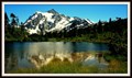
|   Picture Lake — Glacier, WA Picture Lake — Glacier, WA
in Natural Lakes With glacier-clad Mt Shuksan rising to the east and surrounded by forest Picture Lake has become one of the most photographed lakes in North America. Featured on postcards, calendars, and perhaps tens of thousands snapshots by tourists. posted by:  Dunbar Loop Dunbar Loop location: Washington date approved: 07/02/2015 last visited: 07/10/2004 |
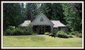
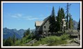 view gallery view galleryW2.4 km |  Heather Meadows Visitor Center — Glacier, WA Heather Meadows Visitor Center — Glacier, WA
in Ranger Stations Starting life as a ski warming hut built by the Civilian Conservation Corps, the Heather Meadows Visitor Center has a national forest ranger on hand to explore the flora, fauna, geological surroundings, and the latest trail conditions. posted by: Dunbar Loop location: Washington date approved: 06/29/2015 last visited: never |
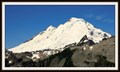
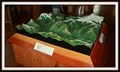 view gallery view galleryW2.4 km |  Mt Baker — Glacier, WA Mt Baker — Glacier, WA
in 3D Map Models of Our World and Beyond In a scale of 1:18,000 this 3D map of Mt Baker and the North Fork of the Nooksack River Valley shows roads, trails, and waterways for the public to orientate themselves with this vast recreational area. posted by: Dunbar Loop location: Washington date approved: 06/29/2015 last visited: never |
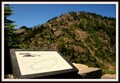
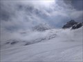
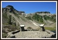 view gallery view galleryW2.6 km |  Fire and Ice Trail #684.2 — Glacier, WA Fire and Ice Trail #684.2 — Glacier, WA
in Places of Geologic Significance Situated in a cirque this interpretive trail takes people on route of discovery of how this type of landform is created. posted by: Dunbar Loop location: Washington date approved: 07/17/2015 last visited: never |
 view gallery view galleryW2.6 km |  Fire & Ice Interpretive Trail — Glacier, WA Fire & Ice Interpretive Trail — Glacier, WA
in Self Guided Walks and Trails Incredible forces of nature work hand-in-hand to create and sculpt the landscape before you. The Fire & Ice Interpretive Trail discusses the volcanic activity builds up Mt Baker, while the ice and frost work to erode the slopes. posted by: Dunbar Loop location: Washington date approved: 07/07/2015 last visited: never |
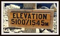 view gallery view gallery SW3.2 km SW3.2 km
|  Artist Point - Glacier, WA. 1,545 meters Artist Point - Glacier, WA. 1,545 meters
in Elevation Signs Artist Point is a popular destination for tourists and hikers trying to get a closer look at Mt. Baker and Mt. Shuskan, two remarkable peaks in the North Cascades. posted by: Dunbar Loop location: Washington date approved: 06/30/2015 last visited: never |
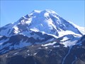
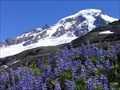
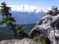
 view gallery view gallerySW3.4 km |  Mount Baker — Glacier, WA Mount Baker — Glacier, WA
in Volcano Watching As part of the Cascade Volcanic Arc, Mt. Baker is considered to be the second most active volcano within the Arc. Only Mt. St. Helens is more active. Mt. Baker's last eruption was in the Autumn of 1880; however, venting is often seen today. posted by: Dunbar Loop location: Washington date approved: 06/27/2015 last visited: 07/04/2022 |
 view gallery view gallery S9.7 km S9.7 km
|  Glacier Peak Glacier Peak
in Mountain Summits Glacier Peak is one of the higher peaks in Washington state that takes a little longer to get to the approach. posted by: E4han location: Washington date approved: 07/02/2008 last visited: never |
 view gallery view gallerySW15.1 km | Mt. Baker - North Cascades, WA in Mountain Summits With good weather this is a great climb and the views are of course like few other. posted by:  lahontan lahontan location: Washington date approved: 09/01/2022 last visited: never |
 view gallery view galleryW15.6 km |  Mt Baker Skyline Divide Trail, Glacier WA Mt Baker Skyline Divide Trail, Glacier WA
in Scenic Hikes One of the most popular scenic hikes on Mt Baker is the Skyline Divide Trail. This trail is along an open ridge heading up towards of the summit on the north side of Mt Baker. posted by: arby101ca location: Washington date approved: 10/11/2010 last visited: never |
 view gallery view gallerySW17.2 km |  Deming Glacier - Mount Baker Deming Glacier - Mount Baker
in Glaciers Deming Glacier on Mt. Baker posted by: E4han location: Washington date approved: 08/24/2008 last visited: 08/12/2020 |
 view gallery view galleryW18.8 km | Mt. Baker, Heliotrope Trail, Glacier, WA in Scenic Hikes The Heliotrope Trail is one of the most scenic hikes on Mt Baker. This hike offers easy access to the trailhead and a varied walk bringing you to the Coleman Glacier and the climbers alpine route to the summit. posted by: arby101ca location: Washington date approved: 09/08/2010 last visited: 02/21/2022 |
 view gallery view galleryW20.9 km |  Smokey Bear — Glacier, WA Smokey Bear — Glacier, WA
in Smokey Bear Sign Sightings Heading up the Mount Baker Highway into the national forest and Smokey is there to tell you about the current fire level. posted by: Dunbar Loop location: Washington date approved: 07/01/2015 last visited: never |
 view gallery view galleryW20.9 km | Glacier Public Service Center — Glacier, WA in Ranger Stations The North Cascades is a rugged and wild place that is popular with hikers and campers. The Glacier Public Service Center has rangers to provide you the latest information for thMt. Baker-Snoqualmie National Forest and North Cascades National Park. posted by: Dunbar Loop location: Washington date approved: 06/25/2015 last visited: never |
 view gallery view galleryW20.9 km |  Glacier Ranger Station — Glacier, WA Glacier Ranger Station — Glacier, WA
in Civilian Conservation Corps Finished in 1938 by the Civilian Conservation Corps the Glacier Ranger Station remains in use by the US Forest Service providing information to visitors to the Mt Baker-Snoqualmie National Forest. posted by: Dunbar Loop location: Washington date approved: 11/01/2010 last visited: never |
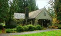 view gallery view galleryW20.9 km |  Glacier Ranger Station — Glacier, WA Glacier Ranger Station — Glacier, WA
in American Guide Series Built by the Civilian Conservation Corps the Glacier Ranger Station remains in use by the US Forest Service providing information to visitors to the Mt Baker-Snoqualmie National Forest. posted by: Dunbar Loop location: Washington date approved: 11/02/2010 last visited: 07/01/2012 |
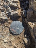
 view gallery view gallery NW20.9 km NW20.9 km
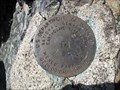
|  Mount McGuire Summit Mount McGuire Summit
in Canadian Benchmarks This survey marker is located at the summit of Mount McGuire. posted by: One Man Clapping location: British Columbia, Canada date approved: 09/08/2009 last visited: 09/16/2009 |
 view gallery view galleryS21.4 km | Anderson Butte in Mountain Summits The mountain is 5,420 feet in elevation, and lies within the Noisy-Diobsud Wilderness. The hike is a short 2 miles (one way), with about 1100 feet of elevation gain. posted by: krazykatzen location: Washington date approved: 08/09/2008 last visited: never |
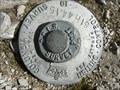
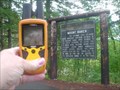
 view gallery view gallerySW21.9 km |  PARK BUTTE REFERENCE PARK BUTTE REFERENCE
in U.S. Benchmarks A USDIGS MONUMENT SET AT THE PARK BUTTE LOOKOUT. posted by: stevebratz location: Washington date approved: 09/01/2010 last visited: never |
 view gallery view gallery N23.7 km N23.7 km
| Borden Creek FSR Survey Disk in Canadian Benchmarks Survey Disk marked with steel post/sign and pile of rocks. posted by: irlpguy location: British Columbia, Canada date approved: 07/31/2010 last visited: 04/19/2020 |
 view gallery view galleryW26.9 km |  Mt. Baker Mt. Baker
in Washington Historical Markers The present-day cone of Mount Baker is relatively young, perhaps less than 30,000 years old, but it sits atop a similar older volcanic cone called Black Buttes Volcano which was active between 500,000 and 300,000 years ago. posted by: SeabeckTribe location: Washington date approved: 04/05/2008 last visited: 09/15/2013 |
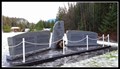
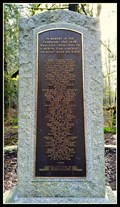 view gallery view galleryNW27.5 km |  Trans-Canada Air Lines Flight 810 — Chilliwack, BC Trans-Canada Air Lines Flight 810 — Chilliwack, BC
in Disaster Memorials 62 people died in December 1956 when Trans-Canada Air Lines Flight 810 flew too low and crashed into Mt Sleese. posted by: Dunbar Loop location: British Columbia, Canada date approved: 07/20/2016 last visited: never |
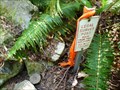
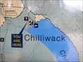 view gallery view gallery NE29.3 km NE29.3 km
|  'You Are Here' map — Chilliwack Lake Provincial Park, BC 'You Are Here' map — Chilliwack Lake Provincial Park, BC
in 'You Are Here' Maps In the campground area of Chilliwack Lake Provincial Park is this map orientating people around the campground and the park. posted by: Dunbar Loop location: British Columbia, Canada date approved: 11/29/2010 last visited: never |
 view gallery view galleryNW29.3 km | Airplane Creek Memorial B-24 Liberator KK241 - June 1st, 1945 — Chilliwack, BC in Disaster Memorials On the morning of Friday, June 1st, 1945 the crew of Liberator KK241 take off from Abbotsford, BC on a navigational training exercise as a part of the RCAF World War II effort. The plane crashed on Mount Walsh just 100 feet shy of the summit posted by: Dunbar Loop location: British Columbia, Canada date approved: 01/19/2016 last visited: never |
 view gallery view gallerySW30.1 km | SISTERS (TQ0669) - Whatcom Co., WA in U.S. Benchmarks Benchmark at summit of South Twin Sister posted by: lahontan location: Washington date approved: 08/07/2022 last visited: never |
|