 view gallery view gallery SE7.9 km SE7.9 km
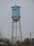
|   Scobey, MT Water Tower Scobey, MT Water Tower
in Water Towers Scobey, MT: City Water Tower
posted by:  The Yoyo Man The Yoyo Man location: Montana date approved: 12/06/2008 last visited: never |
 view gallery view gallery N18 km N18 km
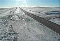
|  Saskatchewan / Montana Border - Highway 13 (USA) / Highway 36 (Canada) Saskatchewan / Montana Border - Highway 13 (USA) / Highway 36 (Canada)
in Border Crossings a border crossing between the Canadian province of Saskatchewan and the US state of Montana located on highway 13 in Montana, USA. posted by:  oiseau_ca oiseau_ca location: Montana date approved: 09/04/2014 last visited: never |
 view gallery view gallery E22.7 km E22.7 km
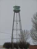
| Flaxville, MT Water Tower in Water Towers Flaxville, MT: City Water Tower posted by: The Yoyo Man location: Montana date approved: 12/06/2008 last visited: never |
 view gallery view galleryE22.9 km |  Flaxville, MT 59222 Flaxville, MT 59222
in U.S. Post Offices Tiny little building in rural town posted by: ZenPanda location: Montana date approved: 10/29/2014 last visited: 10/29/2014 |
 view gallery view galleryN29.8 km |  Coronach Horse Coronach Horse
in Saskatchewan Historical Markers Historical reference to a horse race in 1926. posted by: Altima Voyageur location: Alberta, Canada date approved: 09/22/2013 last visited: never |
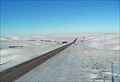
 view gallery view galleryE30.9 km |  Navajo Web Camera - Redstone, MT Navajo Web Camera - Redstone, MT
in Web Cameras This is one of 73 (as of January 2017) Road Weather Information System camera sites operated by the Montana Department of Transportation to aid motorists as they make their way across BIG SKY Country. posted by: T0SHEA location: Montana date approved: 02/04/2017 last visited: never |
 view gallery view gallery NE36.2 km NE36.2 km
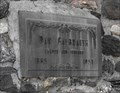
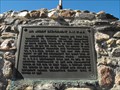
| Dan Galbraith in Saskatchewan Historical Markers This huge cairn was located by an building that was almost missed when I drove by! This is located in the small community of Big Beaver, Saskatchewan. posted by: Altima Voyageur location: Saskatchewan, Canada date approved: 09/29/2013 last visited: never |
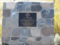
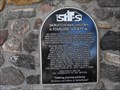 view gallery view galleryNE36.2 km | Big Beaver, Schools that are History! in Saskatchewan Historical Markers This plaque is located on the Dan Galbraith cairn. It mentions all the country schools that were located around the community of Big Beaver. posted by: Altima Voyageur location: Saskatchewan, Canada date approved: 09/29/2013 last visited: never |
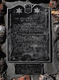 view gallery view galleryNE40.1 km | The Willow Bunch - Big Muddy Trail in Saskatchewan Historical Markers This cain was erected by the South Country Buckaroos, 4H Horse Club in co-operation with the Saskatchewan Department of Natural Resources in the year 1967. posted by: Altima Voyageur location: Saskatchewan, Canada date approved: 09/22/2013 last visited: 07/21/2017 |
 view gallery view gallery S46.5 km S46.5 km
| McDonalds North Web Camera - Scobey, MT in Web Cameras This is one of 73 (as of January 2017) Road Weather Information System camera sites operated by the Montana Department of Transportation to aid motorists as they make their way across BIG SKY Country. posted by: T0SHEA location: Montana date approved: 02/02/2017 last visited: never |
 view gallery view galleryS46.5 km | McDonalds South Web Camera - Scobey, MT in Web Cameras This is one of 73 (as of January 2017) Road Weather Information System camera sites operated by the Montana Department of Transportation to aid motorists as they make their way across BIG SKY Country. posted by: T0SHEA location: Montana date approved: 02/02/2017 last visited: never |
 view gallery view galleryNE48.3 km | Big Muddy Detachment RNWMP/ Last Mounted Horse Patrol in Saskatchewan Historical Markers Unfortunately this is located on private land that has a locked gate. I I was able to see this through a tour that is provided by Big Muddy Tours out of Coronach, Saskatchewan. posted by: Altima Voyageur location: Saskatchewan, Canada date approved: 09/30/2013 last visited: never |
 view gallery view gallery NW49.6 km NW49.6 km
| Saskatchewan Wildlife Federation - Yost Family in Saskatchewan Historical Markers A nice hiking area that was donated by the Yost family. posted by: Altima Voyageur location: Saskatchewan, Canada date approved: 09/25/2013 last visited: never |
 view gallery view galleryNE54.4 km |  Big Muddy Badlands, SK, Canada Big Muddy Badlands, SK, Canada
in Philatelic Photographs This stamp shows the view from southbound highway 34 just before it descends into the Big Muddy Valley in southern Saskatchewan. posted by: hykesj location: Saskatchewan, Canada date approved: 04/03/2017 last visited: never |
 view gallery view galleryN56.2 km |  Little Woody Cemetery, RM of Willow Bunch #42, SK, Canada Little Woody Cemetery, RM of Willow Bunch #42, SK, Canada
in Worldwide Cemeteries A neglected cemetery in rural mid south SK. posted by: kjohn73 location: Saskatchewan, Canada date approved: 04/09/2022 last visited: never |
 view gallery view galleryNW59.2 km | St. Therese Roman Catholic Cemetery - Lisieux Districk, SK, Canada in Worldwide Cemeteries A Prairie cemetery surrounded by healthy trees. posted by: kjohn73 location: Saskatchewan, Canada date approved: 10/17/2011 last visited: never |
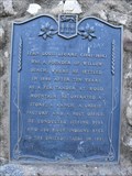 view gallery view galleryN60.2 km | Jean Louis Legare (1841-1918) in Saskatchewan Historical Markers This cairn is located inside Jean Louis Legare Regional Park. The park is just outside of Willow Bunch, Saskatchewan. posted by: Altima Voyageur location: Saskatchewan, Canada date approved: 09/30/2013 last visited: never |
 view gallery view galleryN60.2 km | Leópold Sylvestre in Saskatchewan Historical Markers This is located at the same location as Jean Louis Legare Regional Park. posted by: Altima Voyageur location: Saskatchewan, Canada date approved: 09/30/2013 last visited: never |
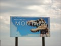
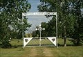
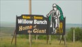 view gallery view galleryN60.4 km |  Home of the Giant - Willow Bunch (Saskatchewan) Canada Home of the Giant - Willow Bunch (Saskatchewan) Canada
in Welcome Signs a welcome sign located on the highway 36 in the town of Willow Bunch (Saskatchewan) Canada posted by: oiseau_ca location: Saskatchewan, Canada date approved: 09/01/2014 last visited: never |
 view gallery view galleryN60.4 km |  Welcome to Willow Bunch - Saskatchewan Welcome to Willow Bunch - Saskatchewan
in Artistic Welcome Signs a welcome sign located on the highway 36 in the town of Willow Bunch (Saskatchewan) Canada posted by: oiseau_ca location: Saskatchewan, Canada date approved: 09/04/2014 last visited: never |
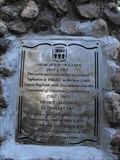
 view gallery view galleryN61.6 km |  CNHP Jean-Louis Légaré 1841-1918 CNHP Jean-Louis Légaré 1841-1918
in Canadian National Historic Sites Located in the community of Willow Bunch posted by: Altima Voyageur location: Saskatchewan, Canada date approved: 11/19/2017 last visited: never |
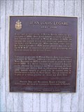
 view gallery view galleryN61.6 km | Jean-Louis Légaré 1841-1918, National Monument in Saskatchewan Historical Markers Located in the community of Willow Bunch posted by: Altima Voyageur location: Saskatchewan, Canada date approved: 09/30/2013 last visited: never |
 view gallery view galleryN61.6 km | In Memory of Edouard Beaupre, The Willow Bunch Giant in Saskatchewan Historical Markers Located outside Willow Bunch Museum, Willow Bunch. posted by: Altima Voyageur location: Saskatchewan, Canada date approved: 09/30/2013 last visited: never |
 view gallery view galleryN62 km | St. Ignace Des Saules Catholic Cemetery, Willow Bunch, SK, Canada in Worldwide Cemeteries Old cemetery in Willow Bunch, SK. posted by: kjohn73 location: Saskatchewan, Canada date approved: 07/22/2020 last visited: never |
 view gallery view galleryNW69.2 km | St. Victors Petroglyphs in Saskatchewan Historical Markers This is a provincial historic park with aboriginal sandstone carvings. Located just south of St. Victor. posted by: Altima Voyageur location: Saskatchewan, Canada date approved: 04/15/2010 last visited: never |
|