 view gallery view gallery SE3.1 km SE3.1 km
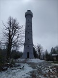
|   Champ du Feu Champ du Feu
in Look-Out Towers Look-out tower on the highest peak of the Central Vosges. posted by:  GEOrgCACHING GEOrgCACHING location: Grand-Est, France date approved: 04/29/2023 last visited: never |
 view gallery view gallery W4 km W4 km
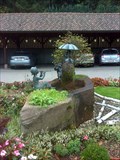
|  La fontaine ''Julien'' (Alsace) La fontaine ''Julien'' (Alsace)
in Fountains Des enfants enchanteurs animent cette fontaine superbe! posted by: gemeloj location: Grand-Est, France date approved: 02/04/2013 last visited: 02/06/2013 |
 view gallery view gallery N5 km N5 km
|  Konzentrationslager Natzweiler-Struthof - Alsace, France Konzentrationslager Natzweiler-Struthof - Alsace, France
in WWII Prisoner of War Camps KZ Natzweiler-Struthof was a German concentration and extermination camp in Alsace. posted by:  ArktiS ArktiS location: Grand-Est, France date approved: 08/19/2009 last visited: 09/03/2015 |
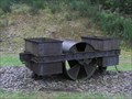 view gallery view galleryN5 km |  Le rouleau compresseur de Schirmeck ( Alsace) Le rouleau compresseur de Schirmeck ( Alsace)
in Last of its Kind Rouleau-compresseur pour l’aplanissement des routes, mu par traction humaine et utilisé au camp. posted by: gemeloj location: Grand-Est, France date approved: 12/01/2012 last visited: 12/06/2012 |
 view gallery view gallery NW5.5 km NW5.5 km
|  La Brocque (Alsace) La Brocque (Alsace)
in Free Overnight RV Parking Locations Un endroit pour y dormir avec son ''camper'' au stade de la Suchette, ici posted by: gemeloj location: Grand-Est, France date approved: 10/15/2012 last visited: 12/06/2012 |
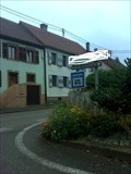
 view gallery view gallerySE6.4 km |  "VOUS ÊTES ICI", Breitenbach, Bas-Rhin/FR "VOUS ÊTES ICI", Breitenbach, Bas-Rhin/FR
in 'You Are Here' Maps YAH Map, on the departure car park of the main hiking trail in the village posted by: CrAzYoTa location: Grand-Est, France date approved: 05/05/2017 last visited: never |
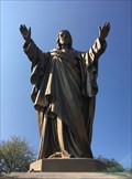 view gallery view gallerySE6.6 km |  Le Sacré Coeur, Breitenbach, Bas-Rhin/FR Le Sacré Coeur, Breitenbach, Bas-Rhin/FR
in Statues of Religious Figures [FR] Statue taille réel du sacré-coeur sur un chemin de randonée / [EN] Real size statue of the sacred-heart on a hiking trail posted by: CrAzYoTa location: Grand-Est, France date approved: 05/08/2017 last visited: never |
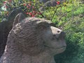 view gallery view gallerySE6.6 km |  Brown Bear Grateful, Breitenbach, Bas-Rhin/FR Brown Bear Grateful, Breitenbach, Bas-Rhin/FR
in Bear Statues Sculpture real sized, of Bear that helped Saint-Gall, below the church Saint-Gall posted by: CrAzYoTa location: Grand-Est, France date approved: 04/19/2017 last visited: 09/04/2014 |
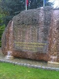 view gallery view galleryN7.1 km |  Défunte Principauté de Salm (La Brocque) (Alsace) Défunte Principauté de Salm (La Brocque) (Alsace)
in Community Commemoration Un petit monument pour commémorer les 200 ans du rattachement de la Principauté de Salm à la France. posted by: gemeloj location: Grand-Est, France date approved: 02/09/2013 last visited: 02/09/2013 |
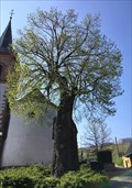 view gallery view gallerySE8.5 km |  Arbre de la liberté, Albé, Bas-Rhin/FR Arbre de la liberté, Albé, Bas-Rhin/FR
in Exceptional Trees [FR] Arbre de la Liberté planté en 1795 / [EN] Tree of Liberty Planted in 1795 posted by: CrAzYoTa location: Grand-Est, France date approved: 05/14/2017 last visited: never |
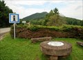
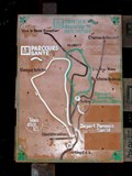 view gallery view gallerySE8.7 km | Parcours de santé - Villé, France in 'You Are Here' Maps [FR] Parcours de santé situé sur les hauteurs de Villé.
[ENG] Fitness trail located on the heights of Villé. posted by: Chris777 location: Grand-Est, France date approved: 08/27/2007 last visited: 08/26/2007 |
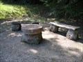 view gallery view gallerySE8.7 km |  Les Hauteurs de Villé - France Les Hauteurs de Villé - France
in Orientation Tables [FR] Une table d'orientation toute simple sur les hauteurs de Villé
[ENG] A very simple orientation table, at the top of Villé. posted by: Chris777 location: Grand-Est, France date approved: 04/04/2008 last visited: 08/26/2007 |
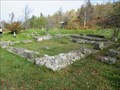
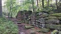 view gallery view gallery E12.2 km E12.2 km
|  Mur païen du mont Sainte-Odile - Mont Ste Odile - France Mur païen du mont Sainte-Odile - Mont Ste Odile - France
in Wikipedia Entries [FR] Vestige d'un mur d'enceinte faisant le tour du plateau du mont Sainte-Odile.[EN] Remains of a wall surrounding the plateau of Mont Sainte-Odile. posted by: PaulLassiter location: Grand-Est, France date approved: 09/18/2021 last visited: never |
 view gallery view galleryNW12.4 km | Émetteur du Donon-Sarrebourg - Grandfontaine - France in Wikipedia Entries [FR] Emetteur de radio et de télévision du département Bas-Rhin et du département de la Moselle. [EN] Radio and television transmitter for the Bas-Rhin department and the Moselle department. posted by: PaulLassiter location: Grand-Est, France date approved: 10/19/2023 last visited: never |
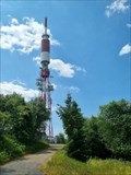 view gallery view galleryNW12.4 km |  Émetteur du Donon-Sarrebourg - Grandfontaine - France Émetteur du Donon-Sarrebourg - Grandfontaine - France
in Radio and Television Transmitter Towers [FR] Emetteur de radio et de télévision du département Bas-Rhin et du département de la Moselle. [EN] Radio and television transmitter for the Bas-Rhin department and the Moselle department. posted by: PaulLassiter location: Grand-Est, France date approved: 10/21/2023 last visited: never |
 view gallery view galleryNW12.4 km |  Summit of Donon - Alsace/France Summit of Donon - Alsace/France
in Ancient Roman Civilization The summit of the Donon in the Vosges du Nord is marked by a historical heritage. posted by:  KaPsTeam KaPsTeam location: Grand-Est, France date approved: 10/04/2014 last visited: 06/17/2023 |
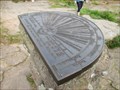 view gallery view galleryNW12.6 km |  Breite 48°30´49" Länge 24°49´55" Orientation table - Donon - Alsace/France Breite 48°30´49" Länge 24°49´55" Orientation table - Donon - Alsace/France
in Permanent Geographic Coordinates Permanent Geographic Coordinates on the orientation table at the summit of the mountain Donon. posted by: KaPsTeam location: Grand-Est, France date approved: 10/06/2014 last visited: 06/17/2023 |
 view gallery view galleryNW12.6 km |  Le Temple du Donon Le Temple du Donon
in French Benchmarks Au sommet de la montagne à 1000m d'altitude,un site Géodésique fort intéressant. Il y de nombreux repères à découvrir, je suis loin de les avoir tous trouvés. posted by: Pat5488 location: Grand-Est, France date approved: 10/19/2008 last visited: 06/17/2023 |
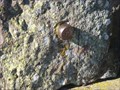 view gallery view galleryNW12.6 km |  TP bolzen-Donon-Lorraine-France TP bolzen-Donon-Lorraine-France
in European Historic Survey Stones, Monuments and Benchmarks a TP bold on the rock! Un poinçon TP dans la roche! posted by: gemeloj location: Grand-Est, France date approved: 03/09/2015 last visited: 03/18/2015 |
 view gallery view galleryNW12.6 km |  Le Donon - Alsace/France Le Donon - Alsace/France
in Mountain Summits The Donon is a mountain in the Vosges in Alsace, France. posted by: KaPsTeam location: Grand-Est, France date approved: 10/06/2014 last visited: 06/17/2023 |
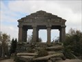 view gallery view galleryNW12.6 km |  Donon - Alsace/France Donon - Alsace/France
in Official Local Tourism Attractions The Donon is a mountain in the Vosges in Alsace, France. posted by: KaPsTeam location: Grand-Est, France date approved: 10/05/2014 last visited: 06/17/2023 |
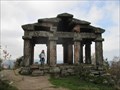 view gallery view galleryNW12.6 km | Le Donon - Alsace/France in Wikipedia Entries The Donon is a mountain in the Vosges in Alsace, France. posted by: KaPsTeam location: Grand-Est, France date approved: 10/04/2014 last visited: 06/17/2023 |
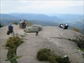 view gallery view galleryNW12.6 km |  View from summit of Donon - Alsace/France View from summit of Donon - Alsace/France
in Scenic Overlooks Great view from the mountain Donon. posted by: KaPsTeam location: Grand-Est, France date approved: 10/04/2014 last visited: 06/17/2023 |
 view gallery view galleryNW12.6 km | Sentier du Donon - Alsace/France in Scenic Hikes Great hike to the summit of the mountain "Donon" posted by: KaPsTeam location: Grand-Est, France date approved: 10/05/2014 last visited: 10/11/2014 |
 view gallery view galleryNW12.6 km | Plate-forme du Donon - Col du Donon, France in Orientation Tables [FR] Table d'orientation située au Col du Donon, face au sommet du Donon.
[ENG] Orientation table located at the Donon pass, in front of the Donon summit. posted by: Chris777 location: Grand-Est, France date approved: 08/24/2008 last visited: 10/11/2014 |
|