 view gallery view gallery NE0.3 km NE0.3 km
|   Blackwell Flats Recreation Area - Libby, MT Blackwell Flats Recreation Area - Libby, MT
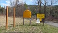
in Campgrounds This campground is on the Kootenai River 18 miles east of Libby, MT and less than four miles south of Libby Dam. posted by:  T0SHEA T0SHEA location: Montana date approved: 12/04/2014 last visited: never |
 view gallery view galleryNE0.3 km | Blackwell Flats Recreation Area - Libby, MT in Free Campsites This free campground is on the Kootenai River 18 miles east of Libby, MT and less than four miles south of Libby Dam. posted by: T0SHEA location: Montana date approved: 12/04/2014 last visited: never |
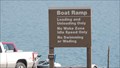
 view gallery view galleryNE0.5 km |  Blackwell Flats Rec Area Ramp - Libby, MT Blackwell Flats Rec Area Ramp - Libby, MT
in Boat Ramps This is one of a bunch of boat ramps available along the Kootenai River east of Libby. posted by: T0SHEA location: Montana date approved: 12/05/2014 last visited: never |
 view gallery view gallery W1.8 km W1.8 km
|  Canoe Gulch Ranger Station - Libby, MT Canoe Gulch Ranger Station - Libby, MT
in Guest Books In the Libby Ranger District, the Canoe Gulch Ranger Station is twelve miles east of the city of Libby along the Kootenai River. posted by: T0SHEA location: Montana date approved: 12/06/2014 last visited: never |
 view gallery view galleryW1.8 km |  Canoe Gulch Ranger Station - Libby, MT Canoe Gulch Ranger Station - Libby, MT
in Ranger Stations In the Libby Ranger District, the Canoe Gulch Ranger Station is twelve miles east of the city of Libby along the Kootenai River. posted by: T0SHEA location: Montana date approved: 12/06/2014 last visited: never |
 view gallery view gallery N2.9 km N2.9 km
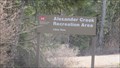
| Alexander Creek Campground - Libby, MT in Free Campsites This small campground is the second one north on Highway 228 toward Libby Dam from Highway 37. posted by: T0SHEA location: Montana date approved: 12/05/2014 last visited: never |
 view gallery view galleryN2.9 km | Alexander Creek Campground - Libby, MT in Campgrounds This small campground is the second one north on Highway 228 toward Libby Dam from Highway 37. posted by: T0SHEA location: Montana date approved: 12/07/2014 last visited: never |
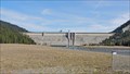
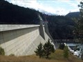 view gallery view galleryN5 km |  Libby Dam, Libby, MT Libby Dam, Libby, MT
in Water Dams Straight concrete gravity gate controlled dam, 370 feet high and 2,887 feet long, on the Kootenai River. Built by the COE (1966-1972) for flood control. posted by: SeabeckTribe location: Montana date approved: 12/12/2008 last visited: 07/30/2010 |
 view gallery view galleryN5 km |  Libby Dam and Lake Koocanusa - Libby, Montana Libby Dam and Lake Koocanusa - Libby, Montana
in Tourist Information Centers - Visitor Centers The visitor's center is located at 260 Souse Gulch Road. It is 28 km west of Libby. Take Hwy. 37 west 22 km then north on National Forest Develop Road 228 6.5 km then right on Souse Gulch Road 360 meters to parking lot. posted by: T0SHEA location: Montana date approved: 09/09/2016 last visited: never |
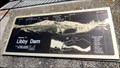
 view gallery view galleryN5.1 km |  Counting display "Libby Dam Data Panel" - Libby, MT Counting display "Libby Dam Data Panel" - Libby, MT
in Counting and Measuring Displays Libby dam was originally conceived as a flood control dam to mitigate flooding downstream on the Kootenai River. Its reservoir, Lake Koocanusa, was named for the treaty formed among the Kootenai Indians and the Canadian and U.S. governments. posted by: T0SHEA location: Montana date approved: 09/06/2019 last visited: never |
 view gallery view galleryN5.1 km |  Libby Dam Visitor Center You Are Here - Libby, MT Libby Dam Visitor Center You Are Here - Libby, MT
in 'You Are Here' Maps This is just one of the UR Here signs at Libby Dam. It's hard to get lost here as they'll tell you at every turn just where you are. posted by: T0SHEA location: Montana date approved: 12/04/2014 last visited: never |
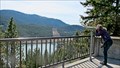
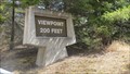 view gallery view galleryN5.1 km |  Libby Dam Lookout - Libby, MT Libby Dam Lookout - Libby, MT
in Scenic Roadside Look-Outs This is one of several viewing opportunities on the west side of Libby Dam and Lake Kookanusa. posted by: T0SHEA location: Montana date approved: 12/04/2014 last visited: never |
 view gallery view galleryN5.1 km |  Libby Dam Binoculars - Libby, MT Libby Dam Binoculars - Libby, MT
in Coin-Op Binoculars At Libby Dam there are a pair of lookouts on the west side of the dam, one above and the other below the dam. At the latter, nearest the Visitor Centre, are two pairs of free binoculars. posted by: T0SHEA location: Montana date approved: 12/26/2014 last visited: never |
 view gallery view galleryN5.1 km | Libby Dam You Are Here - Libby, MT in 'You Are Here' Maps At the viewpoint beside Libby Dam are a pair of Orientation maps. This is the map just below the dam. This one is nearest the visitor centre just to the south. There is a pair of binoculars nearby which the public may use. posted by: T0SHEA location: Montana date approved: 12/04/2014 last visited: never |
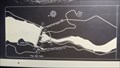
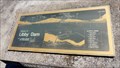
 view gallery view galleryN5.1 km |  The View from Below Libby Dam - Libby, MT The View from Below Libby Dam - Libby, MT
in Orientation Tables At the viewpoint beside Libby Dam are a pair of Orientation maps. This is the map just below the dam. This one is nearest the visitor centre just to the south. There is a pair of binoculars nearby which the public may use. posted by: T0SHEA location: Montana date approved: 12/14/2014 last visited: never |
 view gallery view galleryN5.1 km |  Libby Dam - Libby, MT Libby Dam - Libby, MT
in Official Local Tourism Attractions Libby dam was originally conceived as a flood control dam to mitigate flooding downstream on the Kootenai River. Its reservoir, Lake Koocanusa, was named for the treaty formed among the Kootenai Indians and the Canadian and U.S. governments. posted by: T0SHEA location: Montana date approved: 05/25/2014 last visited: never |
 view gallery view galleryN5.1 km |  Libby Dam - Libby, MT Libby Dam - Libby, MT
in Wikipedia Entries Libby dam was originally conceived as a flood control dam to mitigate flooding downstream on the Kootenai River. Its reservoir, Lake Koocanusa, was named for the treaty formed among the Kootenai Indians and the Canadian and U.S. governments. posted by: T0SHEA location: Montana date approved: 05/23/2014 last visited: never |
 view gallery view galleryN5.1 km |  Alteration of water spill over Montana's Libby Dam may help... Alteration of water spill over Montana's Libby Dam may help...
in News Article Locations Libby dam was originally conceived as a flood control dam to mitigate flooding downstream on the Kootenai River. Its reservoir, Lake Koocanusa, was named for the treaty formed among the Kootenai Indians and the Canadian and U.S. governments. posted by: T0SHEA location: Montana date approved: 03/11/2017 last visited: never |
 view gallery view galleryN5.1 km |  Libby Dam - Libby, MT Libby Dam - Libby, MT
in Lucky 7 Libby dam was originally conceived as a flood control dam to mitigate flooding on the Kootenai River. Its reservoir, Lake Koocanusa, was named for the treaty formed among the Kootenai Indians and the Canadian and U.S. governments. Tally=14 posted by: T0SHEA location: Montana date approved: 02/11/2016 last visited: never |
 view gallery view galleryN5.1 km |  Libby Dam - Libby, MT Libby Dam - Libby, MT
in Hydroelectric Power Stations Libby dam was originally conceived as a flood control dam to mitigate flooding downstream on the Kootenai River. Its reservoir, Lake Koocanusa, was named for the treaty formed among the Kootenai Indians and the Canadian and U.S. governments. posted by: T0SHEA location: Montana date approved: 05/22/2014 last visited: never |
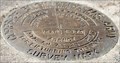 view gallery view galleryN5.1 km |  5+76.25 - Libby Dam - Libby, MT 5+76.25 - Libby Dam - Libby, MT
in U.S. Benchmarks This Corps of Engineers Survey Mark is at the west end of Libby Dam, about 29 km. northeast of Libby, MT along Highway 37 posted by: T0SHEA location: Montana date approved: 06/08/2014 last visited: never |
 view gallery view galleryN5.3 km | The View from Above Libby Dam - Libby, MT in Orientation Tables At the viewpoint beside Libby Dam are a pair of Orientation maps. This is the map just above the dam. posted by: T0SHEA location: Montana date approved: 12/14/2014 last visited: never |
 view gallery view galleryN5.3 km |  Kooky Noosa Course - Libby Dam - Libby, MT Kooky Noosa Course - Libby Dam - Libby, MT
in Disc Golf Courses While taking a tour of the Libby Dam, one can while away a couple more hours by playing a round or two of disc golf, right at the dam, on the Kooky Noosa disc golf course. posted by: T0SHEA location: Montana date approved: 12/06/2014 last visited: never |
 view gallery view galleryN5.3 km | Libby Dam Boat Ramp - Libby, MT in Boat Ramps This is the first boat ramp above Libby dam on the west side of Lake Koocanusa. posted by: T0SHEA location: Montana date approved: 12/05/2014 last visited: never |
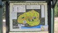
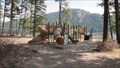 view gallery view galleryN5.5 km |  Souse Gulch Day Use Area - Libby, MT Souse Gulch Day Use Area - Libby, MT
in Public Playgrounds Immediately north of Libby Dam, which is about 17 miles northeast of Libby, MT., is a large day use area which includes a playground. posted by: T0SHEA location: Montana date approved: 12/08/2014 last visited: never |
|