 view gallery view gallery E0.6 km E0.6 km
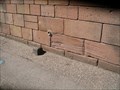
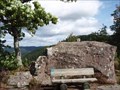
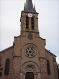
|   Benchmark Abbayes St Pierre d'Etival Benchmark Abbayes St Pierre d'Etival
in French Benchmarks le repère se situe sur le mur de la facade du transept droit, face à la route posted by:  geotrouvtou59 geotrouvtou59 location: Grand-Est, France date approved: 04/30/2017 last visited: 04/23/2017 |
 view gallery view gallery SE3.1 km SE3.1 km
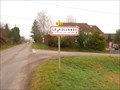
|  La Hollande, Vosges (Lorraine) La Hollande, Vosges (Lorraine)
in Small Town, Big Name Un petit hameau de la Vallée de la Meurthe dans la commune de la Voivre posted by: gemeloj location: Grand-Est, France date approved: 01/17/2013 last visited: 01/18/2013 |
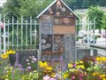 view gallery view galleryE4.3 km |  Insect hotel de l'abbaye-Moyenmoutier-Vosges,France Insect hotel de l'abbaye-Moyenmoutier-Vosges,France
in Insect Hotels Un bel hôtel à insectes dans le parc de l'abbaye. A nice insect hotel in the park of abbey. posted by: gemeloj location: Grand-Est, France date approved: 04/24/2017 last visited: never |
 view gallery view gallery NE4.3 km NE4.3 km
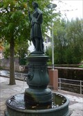
|  Fontaine La Minerve - Moyenmoutier- Gd-Est, France Fontaine La Minerve - Moyenmoutier- Gd-Est, France
in Fountains Une belle fontaine! a beautiful fountain! posted by: gemeloj location: Grand-Est, France date approved: 03/18/2019 last visited: never |
 view gallery view galleryNE4.3 km |  La Fontaine de Minerve-Moyenmoutier-Gd-Est, France La Fontaine de Minerve-Moyenmoutier-Gd-Est, France
in Extraterrestrial Locations La fontaine de Minerve! Minerva fountain! posted by: gemeloj location: Grand-Est, France date approved: 03/13/2019 last visited: never |
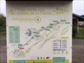
 view gallery view galleryNE4.5 km | La Haute Pierre - Moyenmoutier in French Benchmarks Roche de la Haute Pierre au dessus de Moyenmoutier (88) à 575 m d'altitude posted by: Pat5488 location: Grand-Est, France date approved: 09/07/2008 last visited: 09/07/2008 |
 view gallery view gallery N5 km N5 km
|  Voie Verte de la vallée de la Plaine - Raon l'étape - France Voie Verte de la vallée de la Plaine - Raon l'étape - France
in Rails to Trails La Voie verte de la Vallée de la Plaine est une piste cyclable qui reprend l'emprise de l'ancienne voie ferrée.
The Green Lane of the Plains Valley is a bicycle path that follows the old railway line. posted by: Alfouine location: Grand-Est, France date approved: 05/16/2019 last visited: never |
 view gallery view galleryN5 km |  Voie Verte de la vallée de la Plaine - Raon l'étape - France Voie Verte de la vallée de la Plaine - Raon l'étape - France
in Official Local Tourism Attractions La Voie verte de la Vallée de la Plaine est une piste cyclable qui reprend l'emprise de l'ancienne voie ferrée.
The Green Lane of the Plains Valley is a bicycle path that follows the old railway line. posted by: Alfouine location: Grand-Est, France date approved: 05/11/2019 last visited: never |
 view gallery view galleryN5 km |  Voie Verte de la vallée de la Plaine - Raon l'étape - France Voie Verte de la vallée de la Plaine - Raon l'étape - France
in Cycling Routes La Voie verte de la Vallée de la Plaine est une piste cyclable qui reprend l'emprise de l'ancienne voie ferrée.
The Green Lane of the Plains Valley is a bicycle path that follows the old railway line. posted by: Alfouine location: Grand-Est, France date approved: 05/08/2019 last visited: never |
 view gallery view galleryN5 km |  Museumotel - Raon l'Etape - France Museumotel - Raon l'Etape - France
in Odd-Shaped Buildings Le Museumotel l'Utopie est un motel maison bulle musée sur une île fluviale à Raon-l'Étape dans les Vosges conçu par l'architecte Pascal Haüsermann en 1967. posted by: Alfouine location: Grand-Est, France date approved: 05/19/2019 last visited: never |
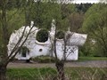 view gallery view galleryN5 km |  Museumotel - Raon l'Etape - France Museumotel - Raon l'Etape - France
in Wikipedia Entries Le Museumotel l'Utopie est un motel maison bulle musée sur une île fluviale à Raon-l'Étape dans les Vosges conçu par l'architecte Pascal Haüsermann en 1967. posted by: Alfouine location: Grand-Est, France date approved: 05/07/2019 last visited: never |
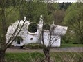 view gallery view galleryN5 km |  le Museumotel de Raon-l'Etape vendu pour 120.000 euros - France le Museumotel de Raon-l'Etape vendu pour 120.000 euros - France
in News Article Locations Le Museumotel l'Utopie est un motel maison bulle musée sur une île fluviale à Raon-l'Étape dans les Vosges conçu par l'architecte Pascal Haüsermann en 1967. posted by: Alfouine location: Grand-Est, France date approved: 05/07/2019 last visited: never |
 view gallery view galleryN5 km |  Museumotel - Raon l'Etape - France Museumotel - Raon l'Etape - France
in Monuments Historiques Français Le Museumotel l'Utopie est un motel maison bulle musée sur une île fluviale à Raon-l'Étape dans les Vosges conçu par l'architecte Pascal Haüsermann en 1967. posted by: Alfouine location: Grand-Est, France date approved: 05/07/2019 last visited: never |
 view gallery view gallery NW5.1 km NW5.1 km
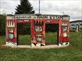
| Bienvenue à Raon l'Etape - France in Welcome Signs A la sortie de la voie express, un rond-point avec une décoration caractéristique de l'art pictural de la région des Vosges.
At the exit of the expressway, a welcome roundabout with a decoration characteristic of the pictorial art of the Vosges. posted by: Alfouine location: Grand-Est, France date approved: 05/08/2019 last visited: never |
 view gallery view galleryNW5.1 km |  Bienvenue à Raon l'Etape - France Bienvenue à Raon l'Etape - France
in Pictorial Village Signs A la sortie de la voie express, un rond-point avec une décoration caractéristique de l'art pictural de la région des Vosges.
At the exit of the expressway, a welcome roundabout with a decoration characteristic of the pictorial art of the Vosges. posted by: Alfouine location: Grand-Est, France date approved: 05/08/2019 last visited: never |
 view gallery view galleryNW5.1 km |  Bienvenue à Raon l'Etape - France Bienvenue à Raon l'Etape - France
in Artistic Welcome Signs A la sortie de la voie express, un rond-point avec une décoration caractéristique de l'art pictural de la région des Vosges.
At the exit of the expressway, a welcome roundabout with a decoration characteristic of the pictorial art of the Vosges. posted by: Alfouine location: Grand-Est, France date approved: 05/12/2019 last visited: never |
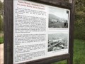
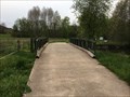
 view gallery view galleryN5.8 km | Pierre-Percée : le pont de la libération et son histoire - France in News Article Locations Posé sur la voie verte à La Trouche, le pont Bailey a été inauguré à l'occasion du 70e anniversaire de la libération de la ville.
Located on the greenway at La Trouche, the Bailey Bridge was inaugurated for the 70th anniversary of the town. posted by: Alfouine location: Grand-Est, France date approved: 05/03/2019 last visited: never |
 view gallery view galleryN5.8 km |  Le Pont Bailey de Raon l'étape - France Le Pont Bailey de Raon l'étape - France
in Relocated Structures Posé sur la voie verte à La Trouche, le pont Bailey a été inauguré à l'occasion du 70e anniversaire de la libération de la ville.
Located on the greenway at La Trouche, the Bailey Bridge was inaugurated for the 70th anniversary of the town. posted by: Alfouine location: Grand-Est, France date approved: 05/04/2019 last visited: never |
 view gallery view galleryN5.8 km | ") Le Pont Bailey de Raon l'étape - France Le Pont Bailey de Raon l'étape - France
in Histoires de France (French historical markers) Posé sur la voie verte à La Trouche, le pont Bailey a été inauguré à l'occasion du 70e anniversaire de la libération de la ville.
Located on the greenway at La Trouche, the Bailey Bridge was inaugurated for the 70th anniversary of the town. posted by: Alfouine location: Grand-Est, France date approved: 05/04/2019 last visited: never |
 view gallery view galleryN5.8 km |  Le Pont Bailey de Raon l'étape - France Le Pont Bailey de Raon l'étape - France
in Bailey Bridges Posé sur la voie verte à La Trouche, le pont Bailey a été inauguré à l'occasion du 70e anniversaire de la libération de la ville.
Located on the greenway at La Trouche, the Bailey Bridge was inaugurated for the 70th anniversary of the town. posted by: Alfouine location: Grand-Est, France date approved: 06/01/2019 last visited: 10/09/2022 |
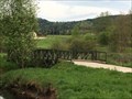
 view gallery view galleryN5.8 km |  La route de la Trouche - France La route de la Trouche - France
in Plank Roads Sur la route menant à la Trouche, un pont en planche de bois.
On the road leading to La Trouche, a bridge made of wood. posted by: Alfouine location: Grand-Est, France date approved: 05/03/2019 last visited: never |
 view gallery view galleryNW6.6 km | Eglise de Thiaville sur Meurthe (54) in French Benchmarks Repère de nivellement cylindrique sur le soubassement en grès du mur de façade de l'église. A droite de la porte. posted by: Pat5488 location: Grand-Est, France date approved: 11/02/2008 last visited: 09/26/2010 |
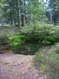 view gallery view gallerySE7.2 km |  Le bassin Taranis (St-Dié) Le bassin Taranis (St-Dié)
in New World Ancient Evidence Un bassin rustique qui était consacré aux Dieux posted by: gemeloj location: Grand-Est, France date approved: 11/01/2012 last visited: 11/05/2012 |
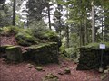 view gallery view gallerySE7.2 km |  Le camp celtique de La Bure (St-Dié)) Le camp celtique de La Bure (St-Dié))
in In Search of the Celts Un camp celtique en pleine nature dans le massif de la Bure posted by: gemeloj location: Grand-Est, France date approved: 10/14/2012 last visited: 10/15/2012 |
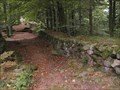 view gallery view gallerySE7.2 km |  Oppidum celte de St-Dié (Lorraine) Oppidum celte de St-Dié (Lorraine)
in Remains of Settlements Un village celte reconstitué dans les années 70 dans le massif de la Bure posted by: gemeloj location: Grand-Est, France date approved: 10/30/2012 last visited: 10/30/2012 |
|