 view gallery view gallery NE4.7 km NE4.7 km
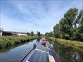
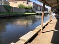
|   Écluse 32 (nord) - Plaine de Charmes - Canal des Vosges - Charmes - France Écluse 32 (nord) - Plaine de Charmes - Canal des Vosges - Charmes - France
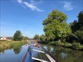
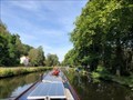
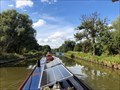
in Waterway Locks, Planes and Lifts This is lock number 32 on the northern slope of the Canal des Vosges and is known as Plaine de Charmes. posted by:  ntpayne ntpayne location: Grand-Est, France date approved: 11/11/2021 last visited: never |
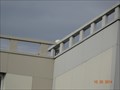 view gallery view galleryNE5 km |  station RGP charmes station RGP charmes
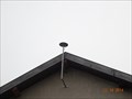
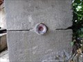
in French Benchmarks sur toit immeuble posted by: geotrou location: Grand-Est, France date approved: 10/20/2014 last visited: 10/22/2014 |
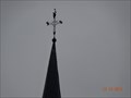
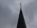
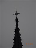
 view gallery view galleryNE5 km | Benchmarck Geodésique Charmes A cheminée in French Benchmarks Cheminée nord :axe et sommet posted by: geotrou location: Grand-Est, France date approved: 10/20/2014 last visited: never |
 view gallery view galleryNE5.1 km | Benchmark Eglise de socourt in French Benchmarks a 30 cm du sol sur le mur droit du chocher posted by: geotrou location: Grand-Est, France date approved: 06/26/2015 last visited: never |
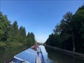
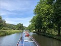
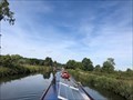 view gallery view galleryNE5.3 km | Écluse 33 (nord) - Socourt - Canal des Vosges - Socourt - France in Waterway Locks, Planes and Lifts This is lock number 33 on the northern slope of the Canal des Vosges and is known as Socourt. posted by: ntpayne location: Grand-Est, France date approved: 11/11/2021 last visited: never |
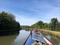 view gallery view galleryNE5.5 km | Écluse 31 (nord) - Charmes - Canal des Vosges - Charmes - France in Waterway Locks, Planes and Lifts This is lock number 31 on the northern slope of the Canal des Vosges and is known as Charmes. posted by: ntpayne location: Grand-Est, France date approved: 11/11/2021 last visited: never |
 view gallery view gallery E5.8 km E5.8 km
| ") Lavoir - Rue du Moulin - Charmes - Vosges (88) - France Lavoir - Rue du Moulin - Charmes - Vosges (88) - France
in Lavoir (wash houses) A canal side lavoir in Charmes, Vosges (88), France. posted by: ntpayne location: Grand-Est, France date approved: 09/20/2021 last visited: never |
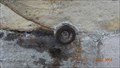
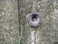
 view gallery view galleryE5.8 km | Benchmarck Géodésique Charmes B église in French Benchmarks Point 1 :centre croix
Point A :centre boule posted by: geotrou location: Grand-Est, France date approved: 10/20/2014 last visited: never |
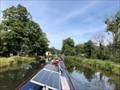
 view gallery view galleryE6 km | Écluse 30 (nord) - Moulin de Charmes - Canal des Vosges - Charmes - France in Waterway Locks, Planes and Lifts This is lock number 30 on the northern slope of the Canal des Vosges and is known as Moulin de Charmes. posted by: ntpayne location: Grand-Est, France date approved: 11/11/2021 last visited: never |
 view gallery view galleryNE6.6 km | Écluse 34 (nord) - Gripport Sud - Canal des Vosges - Gripport - France in Waterway Locks, Planes and Lifts This is lock number 34 on the northern slope of the Canal des Vosges and is known as Gripport Sud. posted by: ntpayne location: Grand-Est, France date approved: 11/11/2021 last visited: never |
 view gallery view gallery W6.8 km W6.8 km
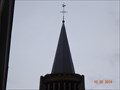
| Benchmarck Géodésique Eglise de mirecourt in French Benchmarks point A clocher :centre boule posted by: geotrou location: Grand-Est, France date approved: 12/14/2014 last visited: never |
 view gallery view galleryE7.6 km | Écluse 29 (nord) - Vincey - Canal des Vosges - Portieux - France in Waterway Locks, Planes and Lifts This is lock number 29 on the northern slope of the Canal des Vosges and is known as Vincey. posted by: ntpayne location: Grand-Est, France date approved: 11/11/2021 last visited: never |
 view gallery view gallery N8 km N8 km
| Écluse 35 (nord) - Gripport Nord - Canal des Vosges - Gripport - France in Waterway Locks, Planes and Lifts This is lock number 35 on the northern slope of the Canal des Vosges and is known as Gripport Nord. posted by: ntpayne location: Grand-Est, France date approved: 11/11/2021 last visited: never |
 view gallery view galleryE8.4 km | Eglise de Vincey in French Benchmarks au début du mur latéral droit de l'eglise a 30 cm de hauteur posted by: geotrou location: Grand-Est, France date approved: 10/04/2014 last visited: never |
 view gallery view galleryE8.4 km | Benchmarck Géodésique église de Vincey in French Benchmarks Point A:clocher centre boule posted by: geotrou location: Grand-Est, France date approved: 10/22/2014 last visited: never |
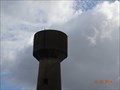 view gallery view galleryE8.4 km | Benchmarck Géodésique chateau d'eau Vincey in French Benchmarks Point A trou d'homme axe et sommet posted by: geotrou location: Grand-Est, France date approved: 10/22/2014 last visited: never |
 view gallery view galleryE9 km | Écluse 28 (nord) - Portieux - Canal des Vosges - Portieux - France in Waterway Locks, Planes and Lifts This is lock number 28 on the northern slope of the Canal des Vosges and is known as Portiuex. It can be found in the village of Portiuex. posted by: ntpayne location: Grand-Est, France date approved: 11/11/2021 last visited: never |
 view gallery view gallery S9.3 km S9.3 km
| Chapelle ND de Pitie in French Benchmarks sur le coté droit de la chapelle posted by: geotrou location: Grand-Est, France date approved: 05/01/2014 last visited: never |
 view gallery view gallery SW9.8 km SW9.8 km
| Station RGP de Mirecourt in French Benchmarks antenne recetption sommet façade batiment INRA posted by: geotrou location: Grand-Est, France date approved: 12/19/2014 last visited: never |
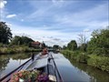
 view gallery view galleryE10.3 km | Écluse 27 (nord) - Fouys - Canal des Vosges - Portieux - France in Waterway Locks, Planes and Lifts This is lock number 27 on the northern slope of the Canal des Vosges and is known as Fouys. posted by: ntpayne location: Grand-Est, France date approved: 11/09/2021 last visited: never |
 view gallery view galleryNE10.5 km | Écluse 36 (nord) - Bainville - Canal des Vosges - Bainville-aux-Miroirs - France in Waterway Locks, Planes and Lifts This is lock number 36 on the northern slope of the Canal des Vosges and is known as Bainville. posted by: ntpayne location: Grand-Est, France date approved: 11/11/2021 last visited: never |
 view gallery view gallerySW10.6 km | Benchmarck Géodésique Eglise de Mattaincourt in French Benchmarks Point A clocher fleuron supérieur: centre posted by: geotrou location: Grand-Est, France date approved: 12/14/2014 last visited: never |
 view gallery view galleryNE11.4 km | Écluse 37 (nord) - Charupt - Canal des Vosges - Bainville-aux-Miroirs - France in Waterway Locks, Planes and Lifts This is lock number 37 on the northern slope of the Canal des Vosges and is known as Charupt. posted by: ntpayne location: Grand-Est, France date approved: 11/11/2021 last visited: never |
 view gallery view galleryE12.2 km | Écluse 26 (nord) - l'Avière - Canal des Vosges - Nomexy - France in Waterway Locks, Planes and Lifts This is lock number 26 on the northern slope of the Canal des Vosges and is known as l'Avière. posted by: ntpayne location: Grand-Est, France date approved: 11/09/2021 last visited: never |
 view gallery view gallery SE12.2 km SE12.2 km
| lavoir St Mathieu in French Benchmarks contre le mur du lavoir posted by: geotrou location: Grand-Est, France date approved: 05/22/2014 last visited: never |
|