 view gallery view gallery E1.1 km E1.1 km
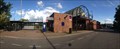
|   Gare de Rouffach, Haut-Rhin, Alsace, France Gare de Rouffach, Haut-Rhin, Alsace, France
in Train Stations/Depots Gare ferroviaire française de la SNCF située sur le territoire de la commune de Rouffach / Train Station in the territory of the town of Rouffach posted by:  CrAzYoTa CrAzYoTa location: Grand-Est, France date approved: 08/10/2016 last visited: never |
 view gallery view gallery SW2.3 km SW2.3 km
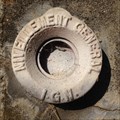
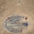
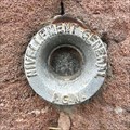
|  A.I.L3 - 111 / 209,652 m A.I.L3 - 111 / 209,652 m
in French Benchmarks Repère cylindrique du nivellement général IGN type M, Rouffach, Haut-Rhin, Alsace, France posted by: CrAzYoTa location: Grand-Est, France date approved: 08/12/2016 last visited: never |
 view gallery view gallery SE6.1 km SE6.1 km
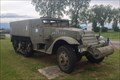
|  Half-Track M3, RMT Meyenheim, Alsace, France Half-Track M3, RMT Meyenheim, Alsace, France
in Military Ground Equipment Displays [FR] Au premier carrefour, à l'entrée nord de Meyenheim / [EN] At the first crossing at the northern entrance of Meyenheim posted by: CrAzYoTa location: Grand-Est, France date approved: 07/07/2016 last visited: never |
 view gallery view gallery W6.1 km W6.1 km
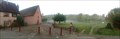
|  Val du Pâtre, Haut-Rhin, Alsace, France Val du Pâtre, Haut-Rhin, Alsace, France
in Boy Scout Camps Base d'acceuil des Scouts et Guides de France du territoire du Haut-Rhin / [EN] Home base since 1930 of the Boy Scouts and Guides of France of the Upper Rhine Territory posted by: CrAzYoTa location: Grand-Est, France date approved: 10/21/2016 last visited: never |
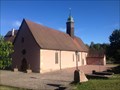 view gallery view galleryW6.1 km |  Schaefertal chapel, Soultzmatt, Alsace, France Schaefertal chapel, Soultzmatt, Alsace, France
in Waychapels Dans une magnifique clairière qui invite à la méditation / [EN] On a beautiful glade, which invites you to meditate / [DE] Auf einer wunderschönen Waldwiese, die zur Meditation einlädt posted by: CrAzYoTa location: Grand-Est, France date approved: 10/21/2016 last visited: never |
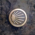 view gallery view galleryW6.1 km |  Way Marker at Schaefertal chapel - Soultzmatt, Alsace, France Way Marker at Schaefertal chapel - Soultzmatt, Alsace, France
in Way of St. James [EN] " In a valley of shepherds, on the Way of St. James... " / [FR] “Dans un val de bergers, sur les chemins de Compostelle...” posted by: CrAzYoTa location: Grand-Est, France date approved: 10/21/2016 last visited: never |
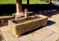 view gallery view galleryW6.1 km |  Spring of Val du Pâtre, Soultzmatt, Alsace, France Spring of Val du Pâtre, Soultzmatt, Alsace, France
in Natural Springs Source Miraculeuse / [EN] Supernatural spring / [DE] Wunderquelle posted by: CrAzYoTa location: Grand-Est, France date approved: 10/20/2016 last visited: never |
 view gallery view gallery N6.9 km N6.9 km
| ") Le "Waschbach" d'Herrlisheim-près-Colmar, France Le "Waschbach" d'Herrlisheim-près-Colmar, France
in Lavoir (wash houses) [FR] La première trace d'un document sur ce lavoir date du 10 novembre 1864 / [EN] The first trace of a document on this washhouse dates from 10/10/1864 / [DE] Die erste Spur eines Dokuments in diesem Waschhaus stammt aus dem 10/10/1864 posted by: CrAzYoTa location: Grand-Est, France date approved: 10/17/2017 last visited: never |
 view gallery view gallerySE6.9 km |  "Football" in Meyenheim - Alsace / France "Football" in Meyenheim - Alsace / France
in Realistic Object Sculptures Football Sculpture made of stone posted by: Iris & Harry location: Grand-Est, France date approved: 09/29/2016 last visited: never |
 view gallery view gallery NE7.1 km NE7.1 km
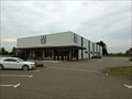
|  ALDI Rue des Alpes, 68127 Niederhergheim - Alsace / France ALDI Rue des Alpes, 68127 Niederhergheim - Alsace / France
in ALDI Stores ALDI Marche 68127 Niederhergheim posted by: Iris & Harry location: Grand-Est, France date approved: 10/01/2016 last visited: never |
 view gallery view galleryE7.2 km | A.I.L3 - 127-I / 202,589 m in French Benchmarks Repère rivet du nivellement général IGN type R , Cimetière d’Oberhergheim, Haut-Rhin, Alsace, France posted by: CrAzYoTa location: Grand-Est, France date approved: 08/03/2016 last visited: never |
 view gallery view galleryE7.4 km | A.I.L3 - 127 BIS / 202,782 m in French Benchmarks Repère cylindrique du nivellement général IGN type M, Cimetière d’Oberhergheim, Haut-Rhin, Alsace, France posted by: CrAzYoTa location: Grand-Est, France date approved: 08/03/2016 last visited: never |
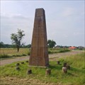
 view gallery view galleryE7.7 km |  Obélisque Terme Nord de la Base d'Oberhergheim - Oberhergheim, Alsace France Obélisque Terme Nord de la Base d'Oberhergheim - Oberhergheim, Alsace France
in Obelisks Stèle géodésique qui est une mire (1804)/ geodesic stele that is the test card (1804) posted by: CrAzYoTa location: Grand-Est, France date approved: 10/05/2016 last visited: never |
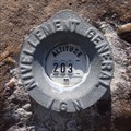
 view gallery view galleryE7.7 km | OBERHERGHEIM IX / 6824209 in French Benchmarks stèle géodésique d'Oberhergheim, mire topographique située dans le département français du Haut-Rhin, en Alsace, entre Mulhouse et Colmar. posted by: CrAzYoTa location: Grand-Est, France date approved: 10/05/2016 last visited: never |
 view gallery view galleryW7.9 km | SOULTZMATT II / 6831802 in French Benchmarks Au Col du Bannstein, Site du Réseau de détail, Soultzmatt, Alsace, France posted by: CrAzYoTa location: Grand-Est, France date approved: 08/12/2016 last visited: never |
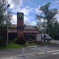 view gallery view gallerySW8.4 km |  McDonald’s - Guebwiller - France McDonald’s - Guebwiller - France
in McDonald's Restaurants Open 7/7 from 08:30am to 10:30pm (Fri & Sat. 11pm) posted by: CrAzYoTa location: Grand-Est, France date approved: 06/19/2016 last visited: never |
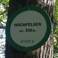 view gallery view galleryW8.5 km |  Hochfelsen - Lautenbach, France / 510m (1674Ft) Hochfelsen - Lautenbach, France / 510m (1674Ft)
in Elevation Signs In the forest, near a Traditional GeoCache (walking time : 5min) posted by: CrAzYoTa location: Grand-Est, France date approved: 06/08/2016 last visited: never |
 view gallery view gallery S8.7 km S8.7 km
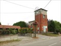
|  Trafotower in Ungersheim - Alsace / France Trafotower in Ungersheim - Alsace / France
in Historic Transformer Sub-Stations Buildings Old Trafotower nearby the road. posted by: Iris & Harry location: Grand-Est, France date approved: 09/29/2016 last visited: 04/15/2017 |
 view gallery view galleryS8.7 km |  Cross near the road, Ungersheim - Alsace / France Cross near the road, Ungersheim - Alsace / France
in Christian Crosses Old Cross, dated 1726. posted by: Iris & Harry location: Grand-Est, France date approved: 09/29/2016 last visited: 04/15/2017 |
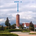
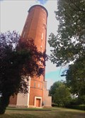 view gallery view galleryS9 km |  Ungersheim's Water Tower, Alsace, France Ungersheim's Water Tower, Alsace, France
in Water Towers Brick-built constructed circular water tower, in 1933. posted by: CrAzYoTa location: Grand-Est, France date approved: 10/26/2016 last visited: 10/26/2016 |
 view gallery view galleryS9 km | UNGERSHEIM I / 6834301 in French Benchmarks Site du Réseau de détail, Ungersheim, Alsace, France posted by: CrAzYoTa location: Grand-Est, France date approved: 10/27/2016 last visited: never |
 view gallery view galleryS9 km | A.I.M3 - 114 / 221,113 m in French Benchmarks Repère cylindrique du nivellement général IGN, type M, Eglise, Ungersheim, Haut-Rhin/FR posted by: CrAzYoTa location: Grand-Est, France date approved: 04/19/2017 last visited: never |
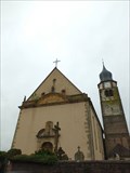 view gallery view galleryS9 km |  Église Saint-Michel, Ungersheim - Alsace / France Église Saint-Michel, Ungersheim - Alsace / France
in Monuments Historiques Français Church dates back to the late eleventh century was rebuilt in 1749. posted by: Iris & Harry location: Grand-Est, France date approved: 09/30/2016 last visited: 04/15/2017 |
 view gallery view galleryS9 km |  Église Saint-Michel, Ungersheim - Alsace / France Église Saint-Michel, Ungersheim - Alsace / France
in Wikipedia Entries Église Saint-Michel d'Ungersheim posted by: Iris & Harry location: Grand-Est, France date approved: 09/28/2016 last visited: 04/15/2017 |
 view gallery view galleryS9 km |  Église Saint-Michel, Ungersheim - Alsace / France Église Saint-Michel, Ungersheim - Alsace / France
in Roman Catholic Churches Church which dates back to the late eleventh century was rebuilt in 1749. posted by: Iris & Harry location: Grand-Est, France date approved: 09/28/2016 last visited: 04/15/2017 |
|