 view gallery view gallery N16.9 km N16.9 km
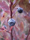
|   Tonga Ridge Area Blueberries Tonga Ridge Area Blueberries
in Berry Picking Wild berries near Snohomish. posted by:  Ambrosia Ambrosia location: Washington date approved: 10/24/2006 last visited: 11/03/2006 |
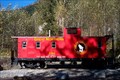
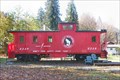
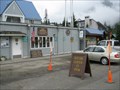
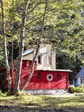 view gallery view galleryN17.2 km |  Cabin made from an old Caboose. Cabin made from an old Caboose.
in Train Cabooses This caboose cabin is located on the south side of Highway 2 near Scenic, Washington. posted by: HeyRob4449 location: Washington date approved: 11/11/2007 last visited: 07/25/2009 |
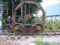
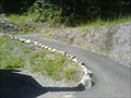 view gallery view galleryN17.2 km |  Iron Goat Trail Iron Goat Trail
in Rails to Trails This trail starts at a rest area off of Highway 2 on the way to Leavenworth and Wenatchee in Washington State. posted by:  bootron bootron location: Washington date approved: 07/30/2007 last visited: 10/31/2009 |
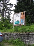
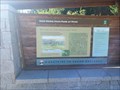
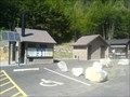 view gallery view galleryN17.2 km |  Iron Goat Trail Rest Area Iron Goat Trail Rest Area
in Highway Rest Areas A convenient stop off of Washington state's highway 2, near the quaint Bavarian hamlet, Leavenworth. posted by: bootron location: Washington date approved: 07/30/2007 last visited: 07/25/2009 |
 view gallery view galleryN17.4 km | Great Northern Caboose X294 @ Iron Goat Trail in Train Cabooses Former Great Northern (& Burlington Northern) Caboose number X-294 is now nicely restored and used as an interpretive center at the west end of the Iron Goat Trail near Stevens Pass Washington. posted by: HeyRob4449 location: Washington date approved: 11/11/2007 last visited: 09/02/2018 |
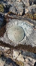 view gallery view gallery NW20.6 km NW20.6 km
|  Maloney Ridge Fire Lookout Site BM TS 17-25 - Skykomish WA Maloney Ridge Fire Lookout Site BM TS 17-25 - Skykomish WA
in U.S. Benchmarks Washington State Highway Department Survey Marker on the Original Maloney Ridge Fire Tower Lookout site. posted by: Winos_Seattle location: Washington date approved: 06/26/2020 last visited: never |
 view gallery view galleryN21.4 km |  Wellington Washington Wellington Washington
in Wikipedia Entries Wellington was on the West side of the original Cascade Tunnel just off the Stevens Pass Highway. posted by: Blue J Wenatchee location: Washington date approved: 11/06/2006 last visited: 10/31/2009 |
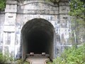
 view gallery view galleryN21.6 km |  Old Cascade Tunnel Old Cascade Tunnel
in Abandoned Train Tunnels The Original Cascade Tunnel posted by: Blue J Wenatchee location: Washington date approved: 07/08/2006 last visited: 10/31/2009 |
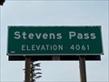 view gallery view galleryN21.7 km |  Stevens Pass - Skykomish, WA - 4061' Stevens Pass - Skykomish, WA - 4061'
in Elevation Signs Highway 2 between Skykomish and Leavenworth, Washington. posted by: WR7X location: Washington date approved: 10/04/2020 last visited: never |
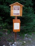 view gallery view galleryN22 km | Pacific Crest Trail - Stevens Pass, WA in Trail Registers Trail Register for the Pacific Crest Trail at Stevens Pass posted by: Prying Pandora location: Washington date approved: 09/08/2008 last visited: never |
 view gallery view galleryNW22.5 km | Great Northern Railway Caboose X228 in Train Cabooses Great Northern Railway Caboose X228, located in Skykomish, Washington. posted by: HeyRob4449 location: Washington date approved: 11/11/2007 last visited: 07/25/2009 |
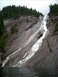
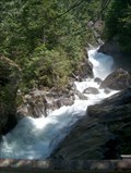 view gallery view gallery W22.5 km W22.5 km
|  Dingford Creek Cascades Dingford Creek Cascades
in Waterfalls Large cascading waterfall near the Middle Fork of the Snoqualmie River. posted by: Prying Pandora location: Washington date approved: 06/03/2007 last visited: 08/28/2008 |
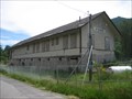 view gallery view galleryNW22.7 km |  Skykomish Depot - Skykomish, Washington Skykomish Depot - Skykomish, Washington
in Train Stations/Depots This depot was built in 1894, shortly after the Great Northern Railway began running trains through Skykomish in 1893. Prior to 1894, a boxcar was used as the depot. posted by: Bluejacket01 location: Washington date approved: 01/03/2012 last visited: 06/25/2020 |
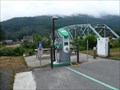
 view gallery view galleryNW23 km |  Skykomish Bridge- 1939 - Skykomish, WA Skykomish Bridge- 1939 - Skykomish, WA
in Bridge Date Stones and Plaques This bridge takes you from Highway 2 into Skykomish. posted by: gypsie2 location: Washington date approved: 08/29/2013 last visited: never |
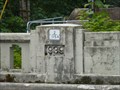
 view gallery view galleryNW23 km |  Skykomish Exit Charging Station, Hwy 2, WA Skykomish Exit Charging Station, Hwy 2, WA
in Electric Car Charging Stations Located on Highway 2 at the turn off to Skykomish. posted by: gypsie2 location: Washington date approved: 08/26/2013 last visited: 06/25/2020 |
 view gallery view galleryW23.5 km | Otter Falls in Waterfalls The third highest waterfall in WA - 1600 feet high! posted by: Prying Pandora location: Washington date approved: 06/20/2007 last visited: 08/21/2013 |
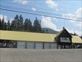 view gallery view gallery SW24.3 km SW24.3 km
|  Snoqualmie Pass Fire & Rescue Snoqualmie Pass Fire & Rescue
in Firehouses This fire station was originally built in the 1930’s as a maintenance shed for the Department of Transportation. posted by: DougK location: Washington date approved: 08/18/2010 last visited: 09/10/2022 |
 view gallery view gallerySW24.3 km |  Snoqualmie Pass Visitor Center, Washington Snoqualmie Pass Visitor Center, Washington
in Ranger Stations This Ranger Station serves the Mt. Baker, Snoqualmie, and Wenatchee National Forests. posted by: Queens Blessing location: Washington date approved: 07/16/2010 last visited: 08/13/2023 |
 view gallery view gallerySW24.3 km |  Smokey Bear at Snoqualmie Pass, Washington Smokey Bear at Snoqualmie Pass, Washington
in Smokey Bear Sign Sightings Smokey the Bear must LOVE living here! It is so beautiful, and it must be fun to watch skiers fly down the hill. posted by: Queens Blessing location: Washington date approved: 07/15/2010 last visited: 07/26/2021 |
 view gallery view gallerySW24.3 km |  Laconia, former Railroad Station, Snoqualmie WA Laconia, former Railroad Station, Snoqualmie WA
in Signs of History This sign represents local history as well as some artwork located here. posted by: Queens Blessing location: Washington date approved: 07/15/2010 last visited: 09/10/2022 |
 view gallery view gallerySW24.3 km |  Snoqualmie Pass Visitors Center, Washington Snoqualmie Pass Visitors Center, Washington
in 'You Are Here' Maps This You Are Here sign is located just outside the Mt Baker/Snoqualmie/Wenatchee National Forests Visitors Center. posted by: Queens Blessing location: Washington date approved: 07/14/2010 last visited: 08/17/2018 |
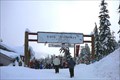 view gallery view gallerySW24.9 km |  The Summit Tubing Center - Snoqualmie Pass, Washington The Summit Tubing Center - Snoqualmie Pass, Washington
in Sledding Places A tubing area near the Snoqualmie ski areas at "The Summit". You must use their tubes and time slots are sold in 2 hour allocations starting at 9 am. Rope tows to the top of the hill. posted by:  Hikenutty Hikenutty location: Washington date approved: 12/27/2006 last visited: 10/12/2020 |
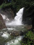 view gallery view gallerySW25.3 km | Franklin Falls in Waterfalls An easily accessible and spectacular waterfall located right off I-90, just west of Snoqualmie Pass. posted by: krazykatzen location: Washington date approved: 07/08/2008 last visited: 06/02/2023 |
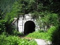
 view gallery view gallerySW25.4 km |  Snoqualmie Tunnel - 1912 - Snoqualmie, WA Snoqualmie Tunnel - 1912 - Snoqualmie, WA
in Dated Architectural Structures Multifarious Dated tunnel in Snoqualmie posted by: stinger503 location: Washington date approved: 09/26/2022 last visited: 07/16/2023 |
 view gallery view gallerySW25.4 km |  Iron Horse State Park - North Bend, WA Iron Horse State Park - North Bend, WA
in State/Provincial Parks [EN] Iron Horse State Park, part of the Washington State Park System, is a 1,612-acre (7 km2) state park located in the Cascade Mountains and Yakima River Valley, between Cedar Falls on the west and the Columbia River on the east. [FR] Le parc d'État d'Iron Horse, qui fait partie du système de parcs d'État de Washington, est un parc d'État de 1 612 acres (7 km2) situé dans les montagnes Cascade et la vallée de la rivière Yakima, entre Cedar Falls à l'ouest et le fleuve Columbia à l'est. posted by: pmaupin location: Washington date approved: 09/09/2022 last visited: 08/17/2022 |
|