 view gallery view gallery W22.9 km W22.9 km
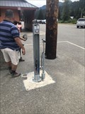
|   Hyak Trailhead Bike Repair Station - Snoqualmie Pass, WA Hyak Trailhead Bike Repair Station - Snoqualmie Pass, WA
in Bicycle Repair Stations Bicycle repair station near the Snoqualmie Tunnel posted by:  stinger503 stinger503 location: Washington date approved: 09/26/2022 last visited: never |
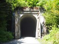
 view gallery view galleryW23 km |  Snoqualmie Tunnel - 1912 - Snoqualmie, WA Snoqualmie Tunnel - 1912 - Snoqualmie, WA
in Dated Architectural Structures Multifarious Dated tunnel in Snoqualmie posted by: stinger503 location: Washington date approved: 09/26/2022 last visited: 07/16/2023 |
 view gallery view galleryW23 km |  Iron Horse State Park - North Bend, WA Iron Horse State Park - North Bend, WA
in State/Provincial Parks [EN] Iron Horse State Park, part of the Washington State Park System, is a 1,612-acre (7 km2) state park located in the Cascade Mountains and Yakima River Valley, between Cedar Falls on the west and the Columbia River on the east. [FR] Le parc d'État d'Iron Horse, qui fait partie du système de parcs d'État de Washington, est un parc d'État de 1 612 acres (7 km2) situé dans les montagnes Cascade et la vallée de la rivière Yakima, entre Cedar Falls à l'ouest et le fleuve Columbia à l'est. posted by: pmaupin location: Washington date approved: 09/09/2022 last visited: 08/17/2022 |
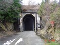 view gallery view galleryW23 km |  Snoqualmie Train Tunnel Snoqualmie Train Tunnel
in Abandoned Train Tunnels This tunnel is located along the Iron Horse Trail. posted by:  GeoBlank GeoBlank location: Washington date approved: 07/14/2006 last visited: 07/16/2023 |
 view gallery view galleryW23 km |  Snoqualmie Trail Tunnel - Snoqualmie Pass, Washington Snoqualmie Trail Tunnel - Snoqualmie Pass, Washington
in Wikipedia Entries an abandoned train tunnel located at Snoqualmie Pass in Washington, USA posted by: oiseau_ca location: Washington date approved: 07/24/2016 last visited: 07/16/2023 |
 view gallery view galleryW23 km | John Wayne Pioneer Trail - Snoqualmie Pass, Washington, USA in Wikipedia Entries a trail following the former railway roadbed of the Chicago, Milwaukee, St. Paul & Pacific Railroad (Milwaukee Road)located in Washington, USA posted by: oiseau_ca location: Washington date approved: 07/24/2016 last visited: 07/16/2023 |
 view gallery view galleryW23 km | Iron Horse State Park - North Bend, WA in Wikipedia Entries [EN] Iron Horse State Park, part of the Washington State Park System, is a 1,612-acre (7 km2) state park located in the Cascade Mountains and Yakima River Valley, between Cedar Falls on the west and the Columbia River on the east.
[FR] Le parc d'État d'Iron Horse, qui fait partie du système de parcs d'État de Washington, est un parc d'État de 1 612 acres (7 km2) situé dans les montagnes Cascade et la vallée de la rivière Yakima, entre Cedar Falls à l'ouest et le fleuve Columbia à l'est. posted by: pmaupin location: Washington date approved: 09/07/2022 last visited: 08/17/2022 |
 view gallery view galleryW23.2 km |  Summit at Snoqualmie, Nordic Center - Washington Summit at Snoqualmie, Nordic Center - Washington
in Winter Sports Locations The Summit Nordic Center is one of three base areas of the Summit at Snoqualmie. This base focuses on cross-country, or Nordic skiing and offers lessons, rentals and food, coffee, cocoa, etc. posted by:  Hikenutty Hikenutty location: Washington date approved: 12/28/2007 last visited: 10/10/2020 |
 view gallery view galleryW23.5 km |  The Summit Tubing Center - Snoqualmie Pass, Washington The Summit Tubing Center - Snoqualmie Pass, Washington
in Sledding Places A tubing area near the Snoqualmie ski areas at "The Summit". You must use their tubes and time slots are sold in 2 hour allocations starting at 9 am. Rope tows to the top of the hill. posted by: Hikenutty location: Washington date approved: 12/27/2006 last visited: 10/12/2020 |
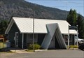
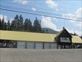 view gallery view galleryW23.7 km |  Snoqualmie Pass Fire & Rescue Snoqualmie Pass Fire & Rescue
in Firehouses This fire station was originally built in the 1930’s as a maintenance shed for the Department of Transportation. posted by: DougK location: Washington date approved: 08/18/2010 last visited: 09/10/2022 |
 view gallery view galleryW23.7 km |  Smokey Bear at Snoqualmie Pass, Washington Smokey Bear at Snoqualmie Pass, Washington
in Smokey Bear Sign Sightings Smokey the Bear must LOVE living here! It is so beautiful, and it must be fun to watch skiers fly down the hill. posted by: Queens Blessing location: Washington date approved: 07/15/2010 last visited: 07/26/2021 |
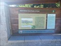
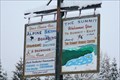
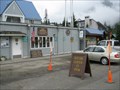 view gallery view galleryW23.7 km |  Snoqualmie Pass Visitor Center, Washington Snoqualmie Pass Visitor Center, Washington
in Ranger Stations This Ranger Station serves the Mt. Baker, Snoqualmie, and Wenatchee National Forests. posted by: Queens Blessing location: Washington date approved: 07/16/2010 last visited: 08/13/2023 |
 view gallery view galleryW23.7 km |  Laconia, former Railroad Station, Snoqualmie WA Laconia, former Railroad Station, Snoqualmie WA
in Signs of History This sign represents local history as well as some artwork located here. posted by: Queens Blessing location: Washington date approved: 07/15/2010 last visited: 09/10/2022 |
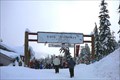
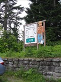
 view gallery view galleryW23.7 km |  Snoqualmie Pass Visitors Center, Washington Snoqualmie Pass Visitors Center, Washington
in 'You Are Here' Maps This You Are Here sign is located just outside the Mt Baker/Snoqualmie/Wenatchee National Forests Visitors Center. posted by: Queens Blessing location: Washington date approved: 07/14/2010 last visited: 08/17/2018 |
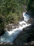
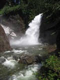 view gallery view galleryW24.9 km |  Franklin Falls Franklin Falls
in Waterfalls An easily accessible and spectacular waterfall located right off I-90, just west of Snoqualmie Pass. posted by: krazykatzen location: Washington date approved: 07/08/2008 last visited: 06/02/2023 |
 view gallery view gallery S25.1 km S25.1 km
|  Easton, Washington 98925 Easton, Washington 98925
in U.S. Post Offices This Post Office is located at 2151 Railroad Street in Easton, Washington. posted by: brwhiz location: Washington date approved: 02/02/2013 last visited: never |
 view gallery view galleryW26.1 km |  Mt. Catherine Mt. Catherine
in Mountain Summits Mt. Catherine, 5052' posted by: M&M location: Washington date approved: 10/02/2007 last visited: 04/15/2020 |
 view gallery view galleryW26.6 km |  John Wayne Pioneer Trail John Wayne Pioneer Trail
in Rails to Trails The Snoqualmie Tunnel is an abandoned railroad tunnel at Snoqualmie Pass at the border of King County and Kittitas County in Washington State. It is 2.3 miles (3.7 km) long. posted by: ILuvAZ location: Washington date approved: 06/19/2013 last visited: 07/16/2023 |
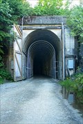 view gallery view galleryW26.6 km | Snoqualmie Tunnel in Abandoned Train Tunnels The Snoqualmie Tunnel is an abandoned railroad tunnel at Snoqualmie Pass at the border of King County and Kittitas County in Washington State. It is 2.3 miles (3.7 km) long. posted by: ILuvAZ location: Washington date approved: 06/23/2013 last visited: 07/16/2023 |
 view gallery view gallery NE26.9 km NE26.9 km
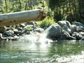
|  Icicle River Icicle River
in Swimming Holes One of the several beautiful holes for swimming in the Icicle River, Leavenworth Washington. posted by: Ambrosia location: Washington date approved: 08/28/2005 last visited: never |
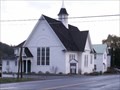 view gallery view galleryS26.9 km |  Mt. Pisgah Presbyterian Church, Roslyn, WA Mt. Pisgah Presbyterian Church, Roslyn, WA
in This Old Church A small church on the main street in Roslyn, WA. posted by: Ambrosia location: Washington date approved: 11/25/2006 last visited: 08/15/2009 |
 view gallery view galleryW27 km | Dingford Creek Cascades in Waterfalls Large cascading waterfall near the Middle Fork of the Snoqualmie River. posted by: Prying Pandora location: Washington date approved: 06/03/2007 last visited: 08/28/2008 |
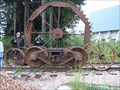
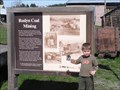 view gallery view galleryS27.2 km |  Roslyn Coal Mining Roslyn Coal Mining
in Washington Historical Markers Roslyn Coal Mining sign next to the museum on Pennsylvania Street in Roslyn. posted by: xy,xx,xy,xy,xy,xy location: Washington date approved: 04/18/2006 last visited: 08/12/2018 |
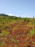 view gallery view galleryW27.7 km |  Hidden Huckleberry Patch Hidden Huckleberry Patch
in Berry Picking This is a secret huckleberry patch that was found as part of a geocache hunt. In fact the point of the cache being there was to point out how it is a great huckleberry picking location. posted by: Jeremy location: Washington date approved: 08/12/2005 last visited: 02/15/2016 |
 view gallery view gallery N28.6 km N28.6 km
| Tonga Ridge Area Blueberries in Berry Picking Wild berries near Snohomish. posted by: Ambrosia location: Washington date approved: 10/24/2006 last visited: 11/03/2006 |
|