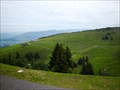
 view gallery view gallery NE3.2 km NE3.2 km
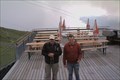
|   Panorama-Wanderweg Andelsbuch-Niedere - Bezau, Vorarlberg, Austria Panorama-Wanderweg Andelsbuch-Niedere - Bezau, Vorarlberg, Austria
in Scenic Hikes Panorama-Wanderweg Andelsbuch-Niedere - Bezau, Vorarlberg, Austria posted by:  luzzi-reloaded luzzi-reloaded location: Vorarlberg, Austria date approved: 10/14/2011 last visited: 07/06/2013 |
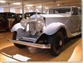 view gallery view gallery W9.3 km W9.3 km
|  Rolls-Royce Museum Rolls-Royce Museum
in Motor Vehicle Museums The Rolls-Royce Museum in the Austrian town Dornbirn is the world's largest Rolls-Royce Museum. posted by: tomduck location: Vorarlberg, Austria date approved: 12/31/2007 last visited: 03/26/2017 |
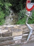
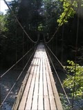 view gallery view galleryNE10.1 km |  "Hängebrücke" - Vorarlberg, Austria "Hängebrücke" - Vorarlberg, Austria
in Pedestrian Suspension Bridges Modern suspension brigde for hikers in Vorarlberg (Austria) posted by:  Gavriel Gavriel location: Vorarlberg, Austria date approved: 11/06/2005 last visited: never |
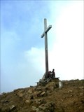 view gallery view gallery SE10.3 km SE10.3 km
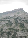
|  Diedamskopf, Vorarlberg - Austria Diedamskopf, Vorarlberg - Austria
in Mountain Summits Diedamskopf in Vorarlberg - Österreich posted by: jotheonly location: Vorarlberg, Austria date approved: 01/31/2016 last visited: 01/31/2016 |
 view gallery view gallerySE10.5 km |  Webcam Diedamskopf, Vorarlberg - Austria Webcam Diedamskopf, Vorarlberg - Austria
in Web Cameras Webcam für persönliche Fotos auf der Gipfelstation des Diedamskopfes.
Webcam for personal photos on the summit station of the Diedamskopf. posted by: jotheonly location: Vorarlberg, Austria date approved: 02/05/2016 last visited: 05/02/2016 |
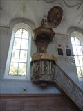 view gallery view gallerySE11.7 km |  Pulpit, Sts. Philip and James - Schoppernau, Vorarlberg Pulpit, Sts. Philip and James - Schoppernau, Vorarlberg
in Stone Church Artefacts The parish church of Sts. Philip and James is a Roman Catholic church in Schoppernau in the Bregenz Forest. posted by: SMacB location: Vorarlberg, Austria date approved: 05/29/2014 last visited: never |
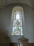 view gallery view gallerySE11.7 km |  Stained Glass Windows, Sts. Philip and James - Schoppernau, Vorarlberg Stained Glass Windows, Sts. Philip and James - Schoppernau, Vorarlberg
in Stained Glass Windows The parish church of Sts. Philip and James is a Roman Catholic church in Schoppernau in the Bregenz Forest. posted by: SMacB location: Vorarlberg, Austria date approved: 05/27/2014 last visited: never |
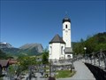 view gallery view gallerySE11.9 km |  Pfarrkirche hll. Philippus und Jakobus - Schoppernau, Vorarlberg Pfarrkirche hll. Philippus und Jakobus - Schoppernau, Vorarlberg
in This Old Church The parish church of Sts. Philip and James is a Roman Catholic church in Schoppernau in the Bregenz Forest. posted by: SMacB location: Vorarlberg, Austria date approved: 05/26/2014 last visited: never |
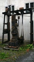 view gallery view galleryW12.6 km |  Lufthammer - Dornbirn, VA, Austria Lufthammer - Dornbirn, VA, Austria
in Preserved Machines on Public Display Lufthammer der Rüschwerke in Dornbirn posted by: jotheonly location: Vorarlberg, Austria date approved: 08/09/2016 last visited: 11/07/2021 |
 view gallery view gallery N12.6 km N12.6 km
|  Sennerei Huban - 6933 Doren, VA, Austria Sennerei Huban - 6933 Doren, VA, Austria
in Dairy Creameries Sennerei und ehem. Landkäereischule Huban in Doren.....Sennerei and former country cheesery school Huban in Doren posted by: jotheonly location: Vorarlberg, Austria date approved: 08/29/2019 last visited: never |
 view gallery view galleryW13.4 km |  great art along the road - Dornbirn great art along the road - Dornbirn
in Murals grafitti art along the road on concrete posted by: speedwalkers location: Vorarlberg, Austria date approved: 12/25/2008 last visited: 05/09/2014 |
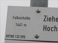 view gallery view galleryNE15.1 km |  Falkenhütte, 1441m - Steibis, Oberstaufen, Lk Oberallgäu, Bayern, D Falkenhütte, 1441m - Steibis, Oberstaufen, Lk Oberallgäu, Bayern, D
in Elevation Signs Falkenhütte 1441m
---
Falkebhütte 4728 feet posted by: lumbricus location: Bayern, Germany date approved: 09/09/2011 last visited: never |
 view gallery view galleryNE15.3 km |  Staatsgrenze Deutschland-Österreich, Balderschwang, Lk Oberallgäu Staatsgrenze Deutschland-Österreich, Balderschwang, Lk Oberallgäu
in Border Crossings Staatsgrenze Deutschland-Österreich bei Balderschwang.
---
State border Germany-Austria in the near of Balderschwang. posted by: lumbricus location: Bayern, Germany date approved: 07/20/2011 last visited: 10/06/2016 |
 view gallery view gallery E15.3 km E15.3 km
|  Gottesacker, Oberstdorf, Lk Oberallgäu Gottesacker, Oberstdorf, Lk Oberallgäu
in Wikipedia Entries Karstlandschaft "Gottesackerplateau" im Allgäu.
---
Karst landscape "Gottesackerplateau", Allgäu. posted by: lumbricus location: Bayern, Germany date approved: 08/19/2011 last visited: 02/25/2014 |
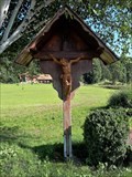 view gallery view galleryN15.4 km |  Wayside Cross nearly Busstop Sulzberg-Süßenwinkel, VA, Austria Wayside Cross nearly Busstop Sulzberg-Süßenwinkel, VA, Austria
in Christian Crosses Wayside Cross nearly Busstop Sulzberg-Süßenwinkel....Kreuz nahe Bushaltestelle Sulzberg-Süßenwinkel posted by: jotheonly location: Vorarlberg, Austria date approved: 09/20/2019 last visited: never |
 view gallery view galleryNE15.6 km | Eineguntkopf bzw. Rohnehöhe - 1639 m - Bavaria, Germany in Mountain Summits "Der Eineguntkopf, beziehungsweise die Rohnehöhe ist ein Berg der Nagelfluhkette am Nordrand der Allgäuer Alpen. Er hat eine Höhe von 1639 m." Wikipedia posted by: lumbricus location: Bayern, Germany date approved: 12/17/2020 last visited: never |
 view gallery view galleryN15.9 km | Staatsgrenze Deutschland-Österreich, Aach , Lk Oberallgäu in Border Crossings Staatsgrenze Deutschland-Österreich bei Aach. --- State border Germany-Austria in the near of Aach. posted by: lumbricus location: Bayern, Germany date approved: 07/20/2011 last visited: 10/06/2016 |
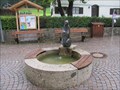 view gallery view galleryN16.1 km |  Brunnen an der Kirche, Aach, Lk Oberallgäu Brunnen an der Kirche, Aach, Lk Oberallgäu
in Fountains Brunnen an der Kirche in Aach bei Oberstaufen.
---
Fountain by the church in Aach near Oberstaufen. posted by: lumbricus location: Bayern, Germany date approved: 07/20/2011 last visited: 08/30/2019 |
 view gallery view gallery NW16.3 km NW16.3 km
| Pfänderwanderung - Bregenz, VA, Austria in Scenic Hikes There are a lot of trails to the top of "Pfänder" where you have a 360° panorama view and a great overlook over the Lake of Constance. posted by: [somnambulist] location: Vorarlberg, Austria date approved: 01/14/2016 last visited: 10/07/2023 |
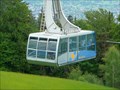 view gallery view galleryNW16.4 km |  Pfänderbahn — Bregenz, Austria Pfänderbahn — Bregenz, Austria
in Aerial Lifts Aerial tramway connecting the city of Bregenz with the Pfänderspitze posted by: prussel location: Vorarlberg, Austria date approved: 12/23/2011 last visited: 10/07/2023 |
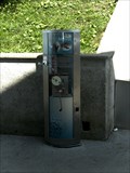 view gallery view galleryNW16.4 km |  Souvenir-Medaille - auf dem Bregenzer Hausberg Souvenir-Medaille - auf dem Bregenzer Hausberg
in Penny Smashers Gerät zum Souvenir Medaille prägen posted by: jotheonly location: Vorarlberg, Austria date approved: 08/15/2011 last visited: 11/06/2017 |
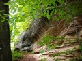 view gallery view galleryNW16.4 km |  Konglomeratfelsen, Vorarlberg, Austria Konglomeratfelsen, Vorarlberg, Austria
in Places of Geologic Significance Konglomeratfelsen, Vorarlberg, Austria posted by: luzzi-reloaded location: Vorarlberg, Austria date approved: 02/18/2012 last visited: 08/15/2021 |
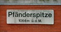 view gallery view galleryNW16.6 km | Pfänderspitze — Bregenz, Austria. 1064 m in Elevation Signs Elevation Sign at the Gasthaus Pfänderspitze posted by: prussel location: Vorarlberg, Austria date approved: 12/21/2011 last visited: 10/07/2023 |
 view gallery view galleryE16.6 km | Gottesacker Scharte, 1967m, Oberstdorf, Lk Oberallgäu in Elevation Signs Schild an der Gottesacker Scharte bei 1967m.
---
Sign at the Gottesacker Scharte (6453feet). posted by: lumbricus location: Bayern, Germany date approved: 07/28/2011 last visited: never |
 view gallery view galleryE16.6 km |  TP Torkopfscharte, Gottesacker, Oberstdorf, Bayern TP Torkopfscharte, Gottesacker, Oberstdorf, Bayern
in German Trigonometric Points Der TP liegt bei der Torkopfscharte mit Blick über den Gottesacker.
---
This German Trigpoint is located at the Torkopfscharte near the Gottesackerplateau. posted by: lumbricus location: Bayern, Germany date approved: 07/27/2011 last visited: never |
|