 view gallery view gallery NW11.6 km NW11.6 km
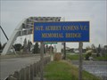
|   Sgt Aubrey Cosens, VC, Memorial Bridge - Latchford, Ontario, Canada Sgt Aubrey Cosens, VC, Memorial Bridge - Latchford, Ontario, Canada
in People-Named Places An arch bridge in memory of a local WWII hero. posted by:  Loonwatcher Loonwatcher location: Ontario, Canada date approved: 08/10/2015 last visited: 09/28/2022 |
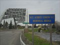 view gallery view galleryNW11.6 km |  Sgt. Aubrey Cosens VC Memorial Bridge - Latchford, Ontario Sgt. Aubrey Cosens VC Memorial Bridge - Latchford, Ontario
in Arch Bridges A recognizable arch bridge commemorating a local WWII Victoria Cross recipient. posted by: Loonwatcher location: Ontario, Canada date approved: 05/20/2015 last visited: 09/28/2022 |
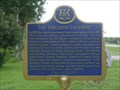
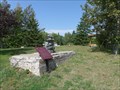
 view gallery view galleryNW11.7 km |  Sgt. Aubrey Cosens, VC - Latchford, Ontario Sgt. Aubrey Cosens, VC - Latchford, Ontario
in Specific Veteran Memorials A roadside rest area and memorial to a local war hero. posted by: Loonwatcher location: Ontario, Canada date approved: 08/07/2013 last visited: 10/03/2022 |
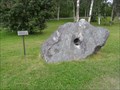 view gallery view galleryNW11.7 km |  Iron Ore Boulder - Latchford, Ontario Iron Ore Boulder - Latchford, Ontario
in Rock and Mineral Displays An iron-ore sample from a local mine, complete with drill hole. posted by: Loonwatcher location: Ontario, Canada date approved: 12/15/2013 last visited: 09/27/2022 |
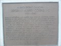
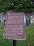
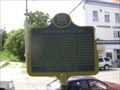
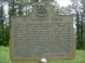
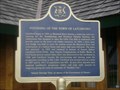 view gallery view galleryNW11.7 km |  "FOUNDING OF THE TOWN OF LATCHFORD" "FOUNDING OF THE TOWN OF LATCHFORD"
in Ontario Provincial Plaques Located in a picnic area just north of the Montreal River bridge on Highway 11. posted by: monkeys4ever location: Ontario, Canada date approved: 08/10/2009 last visited: 09/28/2022 |
 view gallery view galleryNW11.7 km | "FERGUSON HIGHWAY" ~ Town of Latchford in Ontario Provincial Plaques Located in a picnic area just north of the montreal River bridge on Highway 11. posted by: monkeys4ever location: Ontario, Canada date approved: 08/10/2009 last visited: 10/03/2022 |
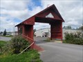 view gallery view galleryNW12.1 km |  SHORTEST -- World's Shortest covered Bridge, Latchford, Ontario SHORTEST -- World's Shortest covered Bridge, Latchford, Ontario
in Superlatives The worlds SHORTEST covered Bridge, or so says the sign. Located at the creek crossing in Latchford, Ontario. The town's slogan is "The Best Little Town by a Dam Site!" posted by: Juicepig location: Ontario, Canada date approved: 10/03/2010 last visited: 09/28/2022 |
 view gallery view galleryNW12.1 km |  World's Shortest covered Bridge- Latchford, Ontario World's Shortest covered Bridge- Latchford, Ontario
in Covered Bridges Listed by Guinness book of world records, the towns claim to fame is the world's shortest covered bridge. Located at the creek crossing in Latchford, Ontario. The town's slogan is "The Best Little Town by a Dam Site!" posted by: Juicepig location: Ontario, Canada date approved: 09/23/2010 last visited: 09/28/2022 |
 view gallery view gallery S12.2 km S12.2 km
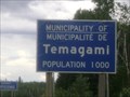
|  Temagami - Ontario, Canada Temagami - Ontario, Canada
in Population Signs Temagami pop. 1000 posted by: monkeys4ever location: Ontario, Canada date approved: 10/22/2009 last visited: 07/12/2023 |
 view gallery view gallery N13.2 km N13.2 km
|  Mining (Silver) National Historic Event of Canada, Cobalt, Ontario Mining (Silver) National Historic Event of Canada, Cobalt, Ontario
in Canadian National Historic Sites There are 2 commemorations of mining in the community of Cobalt. Here, the extraction of silver was a major commercial enterprise. The remaining mining infrastructure gives credence to Cobalt's claim to be the most historic town in Ontario. posted by:  colincan colincan location: Ontario, Canada date approved: 12/30/2016 last visited: never |
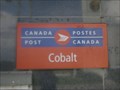 view gallery view galleryN13.4 km |  COBALT PO P0J 1C0 COBALT PO P0J 1C0
in Canada Post Offices This post office is located on 22 Silver Street in Cobalt, Ontario. posted by: monkeys4ever location: Ontario, Canada date approved: 10/23/2009 last visited: 05/18/2015 |
 view gallery view galleryN13.4 km | CNHS - COBALT MINING" in Canadian National Historic Sites An Amazing exhibit near the cobalt mining museum posted by: bwmick location: Ontario, Canada date approved: 06/23/2008 last visited: 07/13/2023 |
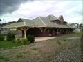 view gallery view galleryN13.4 km |  Cobalt Railway Station Cobalt Railway Station
in Train Stations/Depots Cobalt Railway Station posted by: Cdn Howlers location: Ontario, Canada date approved: 08/16/2012 last visited: 07/13/2023 |
 view gallery view galleryN13.4 km | "COBALT MINING CAMP" in Ontario Provincial Plaques Located in a park at Silver Street in Cobalt. posted by: monkeys4ever location: Ontario, Canada date approved: 08/11/2009 last visited: 07/13/2023 |
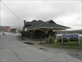 view gallery view galleryN13.4 km |  Cobalt Train Station - Cobalt, ON, Cnada Cobalt Train Station - Cobalt, ON, Cnada
in Ontario Heritage Properties An imposing train station set in an important mining town. posted by: Loonwatcher location: Ontario, Canada date approved: 05/24/2015 last visited: 07/13/2023 |
 view gallery view galleryN13.5 km |  Cobalt Firefighters Museun - Cobalt, Ontario, Canada Cobalt Firefighters Museun - Cobalt, Ontario, Canada
in History Museums Cobalt Firefighter Museum is located at 22 Lang Street in Cobalt, Ontario. posted by: monkeys4ever location: Ontario, Canada date approved: 10/23/2009 last visited: 07/13/2023 |
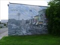 view gallery view galleryN13.5 km |  Lang Street 1911 - Cobalt, Ontario, Canada Lang Street 1911 - Cobalt, Ontario, Canada
in Murals This Mural is painted on the east side of the Firefighter Museum at 22 Lang Street in Cobalt, Ontario. posted by: monkeys4ever location: Ontario, Canada date approved: 10/24/2009 last visited: 07/13/2023 |
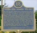 view gallery view galleryN13.5 km | "WILLIAM HENRY DRUMMOND 1854 - 1907" ~ Cobalt in Ontario Provincial Plaques Located at the library on Lang Street in Cobalt. posted by: monkeys4ever location: Ontario, Canada date approved: 08/11/2009 last visited: 05/18/2015 |
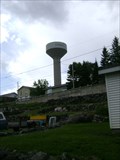 view gallery view galleryN13.8 km |  Cobalt Water Tower - Cobalt, Ontario, Canada Cobalt Water Tower - Cobalt, Ontario, Canada
in Water Towers This water tower is located at the end of Ferland Avenue on the west side of Cobalt, Ontario. posted by: monkeys4ever location: Ontario, Canada date approved: 10/23/2009 last visited: 05/18/2015 |
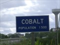 view gallery view galleryN14 km | Cobalt - Ontario, Canada in Population Signs Cobalt pop. 1500 posted by: monkeys4ever location: Ontario, Canada date approved: 10/22/2009 last visited: 09/17/2011 |
 view gallery view gallery NE15.4 km NE15.4 km
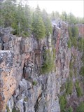
|  Devil's Rock - Lake Timiskaming, Ontario Devil's Rock - Lake Timiskaming, Ontario
in Geological Devilish Locations Devil's Rock is a 300' high escarpment of which 150' is above the surface of Lake Temiskaming. The rock offers 180 degree panoramic view of the lake, its islands, and Quebec on the east shore. Trailhead on Highway 567 at ~N47 24.100 W79 36.018. posted by: Trail Blaisers location: Ontario, Canada date approved: 07/16/2014 last visited: never |
 view gallery view gallery E15.6 km E15.6 km
| "THE TIMISKAMING MISSION" in Ontario Provincial Plaques A plague on an incredibly scenic shoreline. posted by: bwmick location: Ontario, Canada date approved: 06/22/2008 last visited: never |
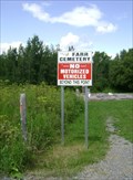 view gallery view galleryN18 km |  Farr Historic Cemetery (Township of Bucke) - Haileysbury, Ontario, Canada Farr Historic Cemetery (Township of Bucke) - Haileysbury, Ontario, Canada
in Worldwide Cemeteries This unique pioneer cemetery is located at the end of Farr Drive in Haileybury, Ontario. posted by: monkeys4ever location: Ontario, Canada date approved: 12/10/2009 last visited: 10/09/2011 |
 view gallery view galleryN19.3 km |  The Haileybury Fire - Haileybury, Ontario, Canada The Haileybury Fire - Haileybury, Ontario, Canada
in Signs of History Located in Harbour Place Park in Haileybury, Ontario. posted by: monkeys4ever location: Ontario, Canada date approved: 12/10/2009 last visited: 07/13/2023 |
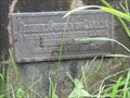 view gallery view galleryN19.3 km |  Vertical Benchmark - 30U1976, Haileybury, Ontario Vertical Benchmark - 30U1976, Haileybury, Ontario
in Canadian Benchmarks A CDN Geodetic Benchmark in a quiet municipal park. posted by: Loonwatcher location: Ontario, Canada date approved: 05/27/2015 last visited: 10/03/2022 |
|