 view gallery view gallery E22 km E22 km
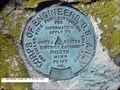
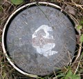
|   U.S. ENGINEERS POINT NO. 6 U.S. ENGINEERS POINT NO. 6
in U.S. Benchmarks USGS BENCH MARK posted by:  Z15 Z15 location: Michigan date approved: 11/01/2007 last visited: never |
 view gallery view gallery SE28.2 km SE28.2 km
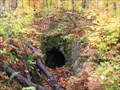
| ") Abandoned Mine Entrance Near Mass City, MI Abandoned Mine Entrance Near Mass City, MI
in Cave Entrances (Artificial) Abandoned mine entrance northeast of Mass City, Michigan. posted by:  Team B Squared Team B Squared location: Michigan date approved: 01/20/2009 last visited: 08/17/2010 |
 view gallery view gallery SW29 km SW29 km
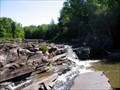
|  Bonanza Falls Bonanza Falls
in Waterfalls A fun place to play! posted by: Trent & Kittie location: Michigan date approved: 09/11/2006 last visited: 07/31/2021 |
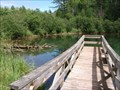
 view gallery view gallerySW32.7 km |  You Are Here at Visitors Center - Porcupine Mountains Wilderness, MI USA You Are Here at Visitors Center - Porcupine Mountains Wilderness, MI USA
in 'You Are Here' Maps Map of the Porcupine Mountains Wilderness of Michigan highlighting the Union Bay Area with a You Are Here at the Visitors Center, near Silver City, Michigan posted by: MountainWoods location: Michigan date approved: 09/30/2016 last visited: 09/25/2016 |
 view gallery view gallerySW34.4 km |  Union Spring Union Spring
in Natural Springs Second largest spring in Michigan, largest in the Upper Penninsula posted by: phatdad location: Michigan date approved: 08/16/2013 last visited: never |
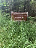 view gallery view gallerySW36.5 km |  Nonesuch Copper Mine - Ontonagon County, Michigan USA Nonesuch Copper Mine - Ontonagon County, Michigan USA
in Mines The Nonesuch Copper Mine in Ontonagon County posted by: theHostas location: Michigan date approved: 08/03/2021 last visited: 08/08/2021 |
 view gallery view gallerySW36.5 km |  Nonesuch Copper Mine - Ontonagon County, Michigan USA Nonesuch Copper Mine - Ontonagon County, Michigan USA
in Wikipedia Entries Wikipedia entry for the Nonesuch Copper Mine in Ontonagon County posted by: theHostas location: Michigan date approved: 08/03/2021 last visited: 08/08/2021 |
 view gallery view gallerySW36.7 km |  Nonesuch Ghost Town - Ontonagon County, Michigan USA Nonesuch Ghost Town - Ontonagon County, Michigan USA
in Ghost Towns Nonesuch Ghost Town in Ontonagon County posted by: theHostas location: Michigan date approved: 08/03/2021 last visited: 08/08/2021 |
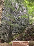
 view gallery view gallerySW39.3 km |  Porcupine Mountains Porcupine Mountains
in Michigan Historical Markers On the north side of M107 in a roadside park about 7.5 miles west of Silver City or M64/M107 intersection. Take a look at the copper mine (now bat cave) on the south side of the road. posted by: S5280ft location: Michigan date approved: 08/19/2006 last visited: 06/19/2016 |
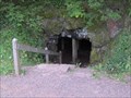 view gallery view gallerySW39.3 km | Carp Lake Mine - Silver City, MI in Cave Entrances (Artificial) An old copper mine within the Porcupine Mountain State Park. posted by: S5280ft location: Michigan date approved: 11/17/2007 last visited: 06/19/2016 |
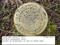
 view gallery view gallerySW39.9 km | USGS 1WRM 1976 in U.S. Benchmarks Basic USGS disk for elevation. posted by: TheRedGoat location: Michigan date approved: 08/17/2008 last visited: never |
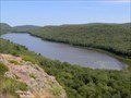
 view gallery view gallerySW41.5 km |  Lake of the Clouds - Ontonagon, Michigan USA Lake of the Clouds - Ontonagon, Michigan USA
in Fishing Holes Lake of the Clouds in the Porcupine Mountains Wilderness State Park posted by: theHostas location: Michigan date approved: 08/01/2021 last visited: 08/08/2021 |
 view gallery view gallerySW41.5 km | Lake of the Clouds - Ontonagon, Michigan USA in Wikipedia Entries Lake of the Clouds in the Porcupine Mountains Wilderness State Park posted by: theHostas location: Michigan date approved: 08/01/2021 last visited: 08/08/2021 |
 view gallery view gallerySW41.5 km |  Lake of the Clouds - Ontonagon, Michigan USA Lake of the Clouds - Ontonagon, Michigan USA
in Natural Lakes Lake of the Clouds in the Porcupine Mountains Wilderness State Park posted by: theHostas location: Michigan date approved: 08/06/2021 last visited: 08/08/2021 |
 view gallery view gallery NE42.2 km NE42.2 km
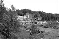
|  Atlantic Mill Ruins -Redridge MI Atlantic Mill Ruins -Redridge MI
in Preserved Architectural Remnants and Ruins The Atlantic Mine Stamp Mill Ruins date back to 1892. The Mill closed in 1912 and was associated with Atlantic Mine (copper), and this site was serviced by Atlantic and Lake Superior Railroad on a 9 mile long track . posted by: kJfishman location: Michigan date approved: 08/06/2016 last visited: never |
 view gallery view galleryNE42.2 km |  Atlantic Mill Ruins - Redridge MI Atlantic Mill Ruins - Redridge MI
in Mills and Gins The Atlantic Mill Ruins near the ghost town of Redridge MI, south and west of Houghton MI. posted by: kJfishman location: Michigan date approved: 01/13/2015 last visited: never |
 view gallery view galleryNE42.2 km |  Atlantic Mill Ruins - Redridge MI Atlantic Mill Ruins - Redridge MI
in Iron Furnace Ruins The Atlantic Mill Ruins date back to 1892. The Mill closed in 1912 and was associated with Atlantic Mine (copper), serviced by Atlantic and Lake Superior Railroad on a 9 mile long track . posted by: kJfishman location: Michigan date approved: 01/15/2015 last visited: never |
 view gallery view gallerySW42.5 km |  Lake of the Clouds Overlook - Ontonagon, Michigan USA Lake of the Clouds Overlook - Ontonagon, Michigan USA
in Scenic Overlooks Lake of the Clouds Overlook in the Porcupine Mountains Wilderness State Park posted by: theHostas location: Michigan date approved: 08/01/2021 last visited: 08/08/2021 |
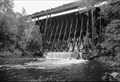
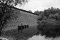
 view gallery view galleryNE42.6 km |  Redridge Steel Dam -1901 - Freda MI Redridge Steel Dam -1901 - Freda MI
in Dated Architectural Structures Multifarious Built when copper was King in the Upper Peninsula the Redridge Steel Dam is a steel dam that spanned the Salmon Trout River in Houghton County, Michigan. It is one of only 3 steel dams built in the United States. It was Built in 1901 posted by: kJfishman location: Michigan date approved: 01/26/2016 last visited: never |
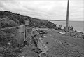
 view gallery view galleryNE42.6 km |  A&LS - Redridge Dam Bridge Hougton County MI A&LS - Redridge Dam Bridge Hougton County MI
in Orphaned Bridges This abandoned railroad bridge is remnant of the days Copper mining was big in the Upper Peninsula. It sits above the historic Redridge Steel Dam. It is not safe to walk across. posted by: kJfishman location: Michigan date approved: 12/27/2021 last visited: never |
 view gallery view galleryNE42.6 km |  Redridge Steel Dam Redridge Steel Dam
in Engineering Landmarks Redridge Steel Dam is a steel dam across the Salmon Trout River in Houghton County, Michigan. posted by: kJfishman location: Michigan date approved: 12/24/2013 last visited: never |
 view gallery view galleryNE42.6 km |  Redridge Steel Dam - Redridge MI Redridge Steel Dam - Redridge MI
in Water Dams Redridge Steel Dam - Redridge MI An American Society of Civil Engineers Engineering Historical site. posted by: kJfishman location: Michigan date approved: 12/27/2021 last visited: never |
 view gallery view galleryE45.7 km | PRIM TRAV STA NO 4 1911 in U.S. Benchmarks A USGS PIPE CAP posted by: Z15 location: Michigan date approved: 11/27/2005 last visited: never |
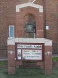 view gallery view galleryE48.9 km |  Holy Family Bell - South Range, MI Holy Family Bell - South Range, MI
in Bells This bell sits in front of the catholic church at the end of TriMountain Avenue. posted by: linkys location: Michigan date approved: 09/03/2011 last visited: 08/20/2018 |
 view gallery view galleryE48.9 km |  1937 - Holy Family Church - South Range, MI 1937 - Holy Family Church - South Range, MI
in Dated Buildings and Cornerstones Cornerstone on a Spanish Mission style church in Michigan's copper country. posted by: linkys location: Michigan date approved: 09/04/2011 last visited: 08/20/2018 |
|