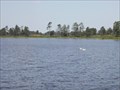
 view gallery view gallery SW1.6 km SW1.6 km
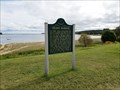
|   Grand Marais Grand Marais
in Michigan Historical Markers This can be found on the outer edge of the bay side park. posted by:  Rattrak Rattrak location: Michigan date approved: 10/30/2017 last visited: 09/15/2018 |
 view gallery view gallerySW1.8 km |  Pickle Barrel House - Grand Marais MI Pickle Barrel House - Grand Marais MI
in Odd-Shaped Buildings Pickle Barrel House in Grand Marais MI is shapped like a pickle barrel. posted by: kJfishman location: Michigan date approved: 08/24/2009 last visited: 08/07/2019 |
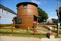 view gallery view gallerySW1.8 km |  Pickle Barrel House - Grand Marais MI Pickle Barrel House - Grand Marais MI
in Roadside Attractions Pickle Barrel House in Grand Marais MI is shaped like a pickle barrel. posted by: kJfishman location: Michigan date approved: 06/06/2016 last visited: 08/07/2019 |
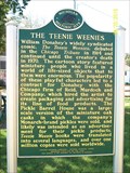 view gallery view gallerySW1.8 km | The Teenie Weenies in Michigan Historical Markers The Teenie Weenies posted by:  just for the fun just for the fun location: Michigan date approved: 05/02/2017 last visited: 06/20/2021 |
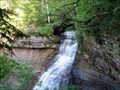
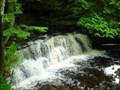
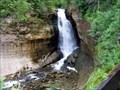
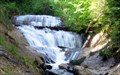 view gallery view gallerySW3.5 km |  Sable Falls Sable Falls
in Waterfalls This waterfall is located off of senic H-58 posted by: Trent & Kittie location: Michigan date approved: 09/17/2006 last visited: 09/07/2017 |
 view gallery view gallerySW4.7 km |  Pictured Rocks Natl Lakeshore Grand Sable VC Pictured Rocks Natl Lakeshore Grand Sable VC
in NPS Passport Cancellation Stations Sandstone cliffs, beaches, sand dunes, waterfalls, lakes, forest, and shoreline beckon you to visit Pictured Rocks National Lakeshore. posted by: nomadwillie location: Michigan date approved: 11/06/2008 last visited: 09/15/2018 |
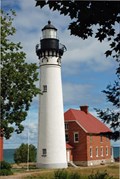 view gallery view gallery W12.9 km W12.9 km
|  Au Sable Point Light Station Au Sable Point Light Station
in Coastal Lighthouses The lighthouse grounds are open year round. Tours of the lighthouse are given a short few months during the summer. The 3 mile round trip hike over firm packed sand follows the Lake Superior shoreline. posted by: moochie location: Michigan date approved: 09/16/2008 last visited: 09/06/2017 |
 view gallery view gallerySW40.1 km | Chapel Falls in Waterfalls This waterfall is located near Pictured Rocks National Lakeshore. posted by: Trent & Kittie location: Michigan date approved: 09/12/2006 last visited: 02/16/2012 |
 view gallery view gallery SE40.6 km SE40.6 km
|  Oswalds Bear Ranch - Newberry, MI Oswalds Bear Ranch - Newberry, MI
in Penny Smashers This penny smasher is located at Oswalds Bear Ranch, 13814 Co. Rd. 407
Newberry, MI posted by: DougandSandra location: Michigan date approved: 08/17/2013 last visited: 07/01/2018 |
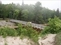 view gallery view gallery E42 km E42 km
|  Two Hearted River North Country Trail Bridge Two Hearted River North Country Trail Bridge
in Pedestrian Suspension Bridges Located at the edge of nowhere, at a beautiful campground on Lake Superior. posted by: S5280ft location: Michigan date approved: 11/23/2007 last visited: 10/29/2011 |
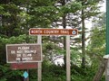 view gallery view galleryE42 km |  NCT at Two-Hearted River State Forest Campground NCT at Two-Hearted River State Forest Campground
in North Country Trail This sign is where the North Country Trail crosses the Big Two-Hearted River on a great suspension bridge. posted by: S5280ft location: Michigan date approved: 11/24/2007 last visited: 07/05/2015 |
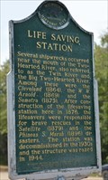 view gallery view galleryE42 km | Life Saving Station in Michigan Historical Markers Its a tough drive just to get a marker with the station not even there. posted by: Historic Markers location: Michigan date approved: 03/19/2018 last visited: 03/13/2018 |
 view gallery view gallerySW43 km | Mosquito Falls in Waterfalls This waterfall is located not far from Chapel Falls. posted by: Trent & Kittie location: Michigan date approved: 09/13/2006 last visited: 07/14/2016 |
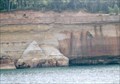
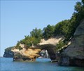 view gallery view gallerySW43.3 km |  Pictured Rocks National Sea Shore - Lake Superior MI Pictured Rocks National Sea Shore - Lake Superior MI
in Natural Arches Pictured Rocks National Sea Shore arch on Lake Superior posted by: kJfishman location: Michigan date approved: 09/01/2009 last visited: 09/20/2022 |
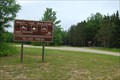 view gallery view gallerySE45.4 km |  Silver Creek Trailhead Silver Creek Trailhead
in Offroad Trails Located in Luce County, this Off-Road Trail is maintained by the Michigan DNR (Department of Natural Resources). This trailhead is located about 2 miles west of M-123. posted by: S5280ft location: Michigan date approved: 07/20/2008 last visited: 07/04/2020 |
 view gallery view gallery S46.5 km S46.5 km
|  Seney National Wildlife Refuge - Michigan Seney National Wildlife Refuge - Michigan
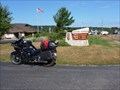
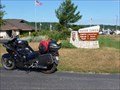
in National Wildlife Refuges The Seney National Wildlife Refuge was established in 1935 for the protection of migratory birds and other wildlife. The Refuge is located in the upper peninsula of Michigan on M-77. posted by: stachowskik location: Michigan date approved: 08/06/2006 last visited: 04/13/2017 |
 view gallery view gallerySW48.6 km | Miners Falls in Waterfalls This waterfall is located close to Pictured Rocks National Lakeshore. posted by: Trent & Kittie location: Michigan date approved: 09/13/2006 last visited: 09/05/2017 |
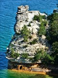 view gallery view gallerySW48.9 km |  Miner's Castle - Pictured Rocks National Lakeshore -MI Miner's Castle - Pictured Rocks National Lakeshore -MI
in Places of Geologic Significance A 42 mile stretch of lakeshore along Lake Superior in the Upper Penisula of Michigan. Miner's Castle is on focal point of the cliffs and sand dunes. posted by: nomadwillie location: Michigan date approved: 03/01/2013 last visited: 09/05/2017 |
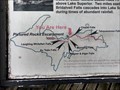
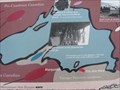 view gallery view gallerySW49.1 km |  Lake Superior Basin Geology Your Are Here Map - Munising, MI Lake Superior Basin Geology Your Are Here Map - Munising, MI
in 'You Are Here' Maps You Are Here map at the overlook at Miners Castle in the Pictured Rocks National Lakeshore. posted by: linkys location: Michigan date approved: 08/03/2011 last visited: 09/05/2017 |
 view gallery view gallerySW49.1 km |  Pictured Rocks National Lakeshore - Munising MI Pictured Rocks National Lakeshore - Munising MI
in Official Local Tourism Attractions Pictured Rocks National Lakeshore is a U.S. National Lakeshore in the Upper Peninsula of Michigan, United States. It extends for 42 miles (67 km) along the shore of Lake Superior and covers 73,236 acres (114 sq. mi; 296 km2). posted by: Don.Morfe location: Michigan date approved: 09/21/2022 last visited: 12/25/2023 |
 view gallery view gallerySW49.1 km | ") Pictured Rocks NL - Michigan Pictured Rocks NL - Michigan
in National Parks (U.S.) Sandstone cliffs, beaches, sand dunes, waterfalls, lakes, forest, and shoreline beckon you to visit Pictured Rocks National Lakeshore. Hiking, camping, sightseeing, and four season outdoor opportunities abound. posted by: nomadwillie location: Michigan date approved: 02/16/2009 last visited: 09/20/2022 |
 view gallery view gallerySW49.1 km | North Country National Scenic Trail - Michigan in National Parks (U.S.) North Country National Scenic Trail
Hiking Adventures in Seven States
The North Country National Scenic Trail links scenic, natural, historic, and cultural areas in seven states.
posted by: nomadwillie location: Michigan date approved: 02/16/2009 last visited: 02/08/2021 |
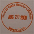 view gallery view gallerySW49.1 km | Pictured Rocks Natl Lakeshore Miners Castle in NPS Passport Cancellation Stations Sandstone cliffs, beaches, sand dunes, waterfalls, lakes, forest, and shoreline beckon you to visit Pictured Rocks National Lakeshore. posted by: nomadwillie location: Michigan date approved: 11/06/2008 last visited: 09/20/2022 |
 view gallery view gallerySW49.1 km |  Pictured Rocks National Lakeshore - Munising MI Pictured Rocks National Lakeshore - Munising MI
in Wikipedia Entries Pictured Rocks National Lakeshore is a U.S. National Lakeshore in the Upper Peninsula of Michigan, United States. It extends for 42 miles (67 km) along the shore of Lake Superior and covers 73,236 acres (114 sq. mi; 296 km2). posted by: Don.Morfe location: Michigan date approved: 09/20/2022 last visited: 12/25/2023 |
 view gallery view gallerySW49.1 km | You Are Here - Pictured Rocks Upper View - Munising MI USA in 'You Are Here' Maps You Are Here at the upper viewing area for Pictured Rocks east posted by: MountainWoods location: Michigan date approved: 09/29/2018 last visited: 09/21/2018 |
|