 view gallery view gallery SE0.3 km SE0.3 km
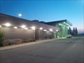
|   Sudbury Airport - Garson, Ontario, Canada Sudbury Airport - Garson, Ontario, Canada
in Airports Air Canada and Porter Airlines fly regularly to/from Toronto to Sudbury and you can catch a flight with Bearskin Air to a number of northern communities. The charter business does well as it serves the mining camps from here. posted by:  Trail Blaisers Trail Blaisers location: Ontario, Canada date approved: 07/21/2014 last visited: 09/01/2018 |
 view gallery view gallery S0.3 km S0.3 km
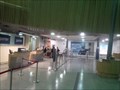
|  Inside Sudbury Airport - Garson, Ontario Inside Sudbury Airport - Garson, Ontario
in Inside Airports Air Canada and Porter Airlines fly regularly to/from Toronto to Sudbury and you can catch a flight with Bearskin Air to a number of northern communities. The charter business does well as it serves the mining camps from here. posted by: Trail Blaisers location: Ontario, Canada date approved: 07/21/2014 last visited: never |
 view gallery view gallery SW10.6 km SW10.6 km
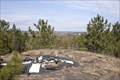
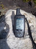
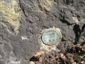
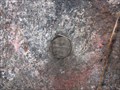
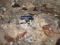
|  Sudbury 750060 Sudbury 750060
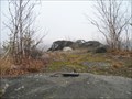
in Canadian Benchmarks A Regional Municipality Of Sudbury horizontal control benchmark accessible off the end of Penman Ave. in Garson Ontario. A walk and a climb is required. posted by:  tec_64 tec_64 location: Ontario, Canada date approved: 03/28/2010 last visited: 04/11/2010 |
 view gallery view galleryS10.8 km | 027SPT-10 in Canadian Benchmarks One of a group of 10 located in the eastern part of the City Of Greater Sudbury, Ontario. Accessible from Regional Road 90 (Garson-Coniston Road) and a round-trip hike of about 2.2 kms. posted by: tec_64 location: Ontario, Canada date approved: 08/29/2011 last visited: never |
 view gallery view gallery W11.9 km W11.9 km
| 36U2365 Garson Lake in Canadian Benchmarks A Geodetic Survey of Canada Benchmark beside CN rail line 7.6 Km south of the Hanmer station. posted by: broder location: Ontario, Canada date approved: 04/27/2010 last visited: never |
 view gallery view gallerySW13.7 km | Sudbury 64-49 in Canadian Benchmarks Topographical Survey Monument destroyed posted by: broder location: Ontario, Canada date approved: 03/28/2010 last visited: never |
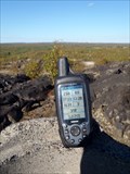 view gallery view galleryS14.2 km | 027SPT-2 in Canadian Benchmarks One of a group of 10 located in the eastern part of the City Of Greater Sudbury, Ontario. Accessible from the north side of Highway 17 just west of RR90 Garson-Coniston Road and a round-trip hike of about 5 kms. posted by: tec_64 location: Ontario, Canada date approved: 09/17/2011 last visited: 09/18/2011 |
 view gallery view gallery NW14.2 km NW14.2 km
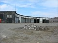
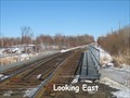
|  CN Roundhouse - Capreol, Ontario CN Roundhouse - Capreol, Ontario
in Railway Roundhouses This roundhouse is in Canadian National's yard in Capreol, Ontario. It is no longer used for engine repairs, as the turntable has been removed, but is still used by the railway as a mechanical building. posted by: Cedar Grove Seekers location: Ontario, Canada date approved: 04/24/2008 last visited: 12/04/2010 |
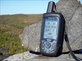 view gallery view galleryS14.3 km | 027SPT-8 in Canadian Benchmarks One of a group of 10 located in the eastern part of the City Of Greater Sudbury, Ontario. Accessible from the north side of Highway 17 just east of RR90 Garson-Coniston Road and a round-trip hike of about 3 kms. posted by: tec_64 location: Ontario, Canada date approved: 09/12/2011 last visited: never |
 view gallery view gallerySW14.8 km | Sudbury 69-09 in Canadian Benchmarks INCO triangulation station 69-09 posted by: broder location: Ontario, Canada date approved: 04/29/2010 last visited: never |
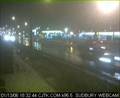 view gallery view gallerySW14.8 km |  New Sudbury - CJTK New Sudbury - CJTK
in Web Cameras A view from the east end of Lasalle Blvd. posted by: L&theBoys location: Ontario, Canada date approved: 12/18/2005 last visited: 11/10/2012 |
 view gallery view galleryS14.8 km | 027SPT-3 in Canadian Benchmarks One of a group of 10 located in the eastern part of the City Of Greater Sudbury, Ontario. Accessible from the north side of Highway 17 at the bottom of the hill in the village of Wahnapitae, and a round-trip hike of less than 3 kms. posted by: tec_64 location: Ontario, Canada date approved: 08/10/2012 last visited: never |
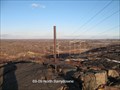
 view gallery view gallerySW15.3 km | 027790043 in Canadian Benchmarks Regional Municipality of Sudbury - Horizontal Control. Its top of a peak of Falconbridge Rd area. Great view from the top. posted by: jwinther location: Ontario, Canada date approved: 11/03/2010 last visited: 11/13/2010 |
 view gallery view gallerySW15.3 km | Sudbury 64-47 in Canadian Benchmarks A 1964 topographical survey monument which has been destroyed is located west of the south end of Brookfield Ave in New Sudbury and 12 meters south and 4 meters west of Waymark 02719790043. posted by: broder location: Ontario, Canada date approved: 11/15/2010 last visited: never |
 view gallery view gallerySE15.4 km | CPR Cartier Sub - MP 62.05 in Canadian Benchmarks 1921 CGC Survey bolt located at Milepost 62.05 on the CPR Cartier Subdivision posted by: bandsaw1 location: Ontario, Canada date approved: 03/28/2010 last visited: never |
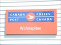 view gallery view galleryS15.8 km |  Wahnapitae P.O. P0M 3C0 Wahnapitae P.O. P0M 3C0
in Canada Post Offices Wahnapitae Post office posted by: bushman003 location: Ontario, Canada date approved: 06/19/2010 last visited: 02/10/2011 |
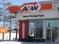 view gallery view galleryW15.9 km |  A & W Restaurant in Val Caron, ON A & W Restaurant in Val Caron, ON
in A + W Restaurants Local A&W Restaurant in Val Caron, ON posted by: SweetPea57 location: Ontario, Canada date approved: 01/20/2015 last visited: 04/22/2023 |
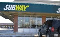 view gallery view galleryW16.1 km |  Subway - Val Caron, ON Subway - Val Caron, ON
in Subway Restaurants Subway restaurant posted by: SweetPea57 location: Ontario, Canada date approved: 01/20/2015 last visited: 04/22/2023 |
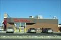 view gallery view galleryW16.1 km |  Tim Hortons - Val Caron, ON Tim Hortons - Val Caron, ON
in Tim Horton's Restaurants Tim Hortons restaurant posted by: SweetPea57 location: Ontario, Canada date approved: 01/22/2015 last visited: 04/22/2023 |
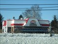 view gallery view galleryW16.1 km |  Dairy Queen - Val Caron, ON Dairy Queen - Val Caron, ON
in Dairy Queen Restaurants Dairy Queen in Val Caron, ON posted by: SweetPea57 location: Ontario, Canada date approved: 01/20/2015 last visited: 04/22/2023 |
 view gallery view galleryS16.9 km | Sudbury 64-32 in Canadian Benchmarks A 1964 Horizontal control point that utilized a 1929 Topographical Disk. It is located just east and south of the SW bypass bridge over the CPR tracks near Romford. posted by: broder location: Ontario, Canada date approved: 11/26/2010 last visited: never |
 view gallery view gallerySW17.1 km | Sudbury 64-36 Kingsway East in Canadian Benchmarks A Topographical Survey Monument located Southwest Side Kingsway Southeast of Third Ave posted by: broder location: Ontario, Canada date approved: 03/12/2010 last visited: never |
 view gallery view gallerySW17.2 km | Sudbury 64-35 in Canadian Benchmarks A Topographical survey monument. posted by: broder location: Ontario, Canada date approved: 03/16/2010 last visited: never |
 view gallery view gallerySW17.4 km | Tim Hortons - Sudbury, ON in Tim Horton's Restaurants Located at the corner of Kingsway Rd and Barrydowne Rd in Sudbury, Ontario. posted by: monkeys4ever location: Ontario, Canada date approved: 08/20/2008 last visited: 01/27/2015 |
 view gallery view gallerySW17.5 km | BM near Junction Creek Sudbury ON in Canadian Benchmarks Tablet in face of outcrop NE bridge over Junction Creek The station in the description is long gone, urban renewal and the posted coodinates were scaled. Used the bridge and track measurements to find the tablet. posted by: broder location: Ontario, Canada date approved: 03/07/2010 last visited: never |
|