 view gallery view gallery W4.5 km W4.5 km
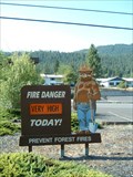
|   Gone - Clearwater National Forest Smokey - Orofino, Idaho Gone - Clearwater National Forest Smokey - Orofino, Idaho
in Smokey Bear Sign Sightings Smokey Bear sign in front of Clearwater National Forest - North Fork Ranger Station in Orofino, Idaho. Unfortunately this Smokey has been removed. posted by:  BruceS BruceS location: Idaho date approved: 09/08/2007 last visited: 07/29/2013 |
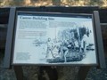 view gallery view galleryW5.6 km |  Canoe-Building Site Canoe-Building Site
in Lewis and Clark Trail Historical marker commemorating the location where Lewis and Clark Expedition built canoes to continue their westward trip after their arduous overland travel. posted by: BruceS location: Idaho date approved: 09/08/2007 last visited: 05/19/2017 |
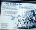 view gallery view galleryW5.6 km |  Canoe-Building Site Canoe-Building Site
in Idaho Historical Markers Historical marker commemorating the location where Lewis and Clark Expedition built canoes to continue their westward trip after their arduous overland travel. posted by: BruceS location: Idaho date approved: 09/09/2007 last visited: 05/19/2017 |
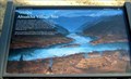
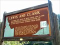 view gallery view gallery SE5.6 km SE5.6 km
| Lewis and Clark in Idaho Historical Markers Historical marker commemorating the Lewis and Clark Expedition finally reaching a westward river on their journey, thus ending their overland portion. posted by: BruceS location: Idaho date approved: 09/08/2007 last visited: 05/14/2015 |
 view gallery view galleryW5.8 km | ?asáqa -Ahsakha Village Site in Idaho Historical Markers Historical marker referencing the Indian village where Lewis and Clark built five canoes to continue their westward journey. posted by: BruceS location: Idaho date approved: 09/08/2007 last visited: 05/19/2017 |
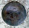 view gallery view galleryW5.8 km |  Corps of Discovery II - Canoe Camp - Ahsahka, Idaho Corps of Discovery II - Canoe Camp - Ahsahka, Idaho
in U.S. Benchmarks Corps of Discovery II disklocated in Canoe Camp area of the Nez Perce National Historic Park near Ahsahka, Idaho. posted by: BruceS location: Idaho date approved: 09/08/2007 last visited: 05/19/2017 |
 view gallery view galleryW5.8 km | ") Canoe Camp - Nez Perce National Historic Park Canoe Camp - Nez Perce National Historic Park
in National Parks (U.S.) Canoe Camp is a site in the Nez Perce National Historic Park in Idaho. posted by: BruceS location: Idaho date approved: 09/08/2007 last visited: 05/19/2017 |
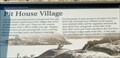 view gallery view galleryW5.8 km | Pit House Village in Idaho Historical Markers Historical marker about a Native American village located along the Clearwater River in Idaho. posted by: BruceS location: Idaho date approved: 09/09/2007 last visited: 05/19/2017 |
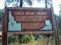 view gallery view gallerySE13.4 km | Gold Rush Ferry in Idaho Historical Markers Historical marker commemorating a ferry which transported prospectors across the river in 1860. posted by: BruceS location: Idaho date approved: 09/08/2007 last visited: 05/19/2017 |
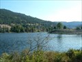
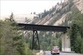
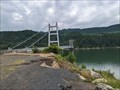 view gallery view gallery NE14.6 km NE14.6 km
|  Dent Bridge Dent Bridge
in Suspension Bridges Dent Bridge spans the Dworshak Reservoir in Clearwater County. It is both the tallest and highest bridge in Idaho. posted by:  Wolfmoat Wolfmoat location: Idaho date approved: 06/12/2023 last visited: never |
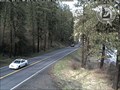
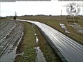 view gallery view gallerySE15.3 km |  Top of Greer Grade Web Camera - Weippe, MT Top of Greer Grade Web Camera - Weippe, MT
in Web Cameras This is one of about 150 highway traffic cameras in Idaho which cover every major and a great many of the minor thoroughfares in the state, as well as many of the towns and cities. posted by:  T0SHEA T0SHEA location: Montana date approved: 04/04/2017 last visited: never |
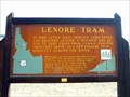 view gallery view galleryW22.7 km | Lenore Tram in Idaho Historical Markers Historical marker commemorating a former aerial tram which operated in the area of the marker. posted by: BruceS location: Idaho date approved: 09/08/2007 last visited: 06/08/2009 |
 view gallery view galleryW23.3 km | Slaterville in Idaho Historical Markers Historical marker commemorating the ghost town of Slaterville, Idaho. posted by: BruceS location: Idaho date approved: 09/08/2007 last visited: never |
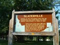 view gallery view galleryW23.3 km |  Slaterville, Idaho Slaterville, Idaho
in Ghost Towns Slaterville, Idaho was founded as a steamboat port in 1861 but was short lived as it was replaced by Lewiston as the steamboat port. posted by: BruceS location: Idaho date approved: 09/08/2007 last visited: never |
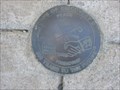 view gallery view gallerySE29.8 km | CORPS OF DISCOVERY II - WEIPPE PRAIRIE, ID in U.S. Benchmarks CORPS OF DISCOVERY II - WEIPPE PRAIRIE, ID, is a four-inch commemorative disk set to commemorate the 200th anniversary of Lewis and Clark's contact with the Nez Perce (September, 1805). posted by: seventhings location: Idaho date approved: 09/11/2008 last visited: never |
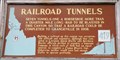 view gallery view gallery SW31.1 km SW31.1 km
| #419 - Railroad Tunnels in Idaho Historical Markers Railroad Tunnels history sign (#419) along US Hwy 95. posted by: Volcanoguy location: Idaho date approved: 01/19/2011 last visited: 09/29/2009 |
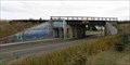
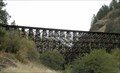 view gallery view gallerySW31.1 km |  Rock Creek and Halfmoon Trestles - Idaho Rock Creek and Halfmoon Trestles - Idaho
in Railroad Bridges Two railroad trestles along US Hwy 95. posted by: Volcanoguy location: Idaho date approved: 01/19/2011 last visited: 06/20/2019 |
 view gallery view gallerySE31.4 km | Kamiah North Webcam - Kamiah, ID in Web Cameras This is one of about 150 highway traffic cameras in Idaho which cover every major and a great many of the minor thoroughfares in the state, as well as many of the towns and cities. posted by: T0SHEA location: Idaho date approved: 03/31/2017 last visited: never |
 view gallery view gallerySW31.7 km |  Lake Scene Mural - Craigmont, Idaho Lake Scene Mural - Craigmont, Idaho
in Murals This mural displays a mountain lake scene. posted by: Volcanoguy location: Idaho date approved: 01/20/2011 last visited: 09/29/2009 |
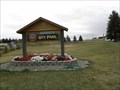 view gallery view gallerySW31.7 km |  City Park - Craigmont, Idaho City Park - Craigmont, Idaho
in Municipal Parks and Plazas The City Park for the community of Craigmont, Idaho. posted by: Volcanoguy location: Idaho date approved: 01/20/2011 last visited: 09/29/2009 |
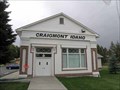
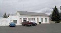 view gallery view gallerySW31.7 km |  Craigmont, Idaho Craigmont, Idaho
in City and Town Halls City Hall for the community of Craigmont, Idaho. posted by: Volcanoguy location: Idaho date approved: 01/20/2011 last visited: 09/29/2009 |
 view gallery view gallerySW31.7 km |  Craigmont, ID. 83523 {RETIRED} Craigmont, ID. 83523 {RETIRED}
in U.S. Post Offices A former post office builting in Craigmont, Idaho. posted by: Volcanoguy location: Idaho date approved: 01/22/2011 last visited: 09/29/2009 |
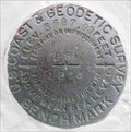 view gallery view gallerySW31.7 km | RZ0129 - USCGS P24, Idaho in U.S. Benchmarks U.S. Coast & Geodetic Survey Benchmark P24. posted by: Volcanoguy location: Idaho date approved: 01/19/2011 last visited: 09/29/2009 |
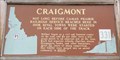 view gallery view gallerySW31.7 km | #331 - Craigmont (#1) in Idaho Historical Markers Craigmont history sign (#331) in Craigmont City Park. posted by: Volcanoguy location: Idaho date approved: 01/19/2011 last visited: 09/29/2009 |
 view gallery view gallerySW31.9 km | Camas Prairie Railroad Bridge over US Hwy 95 - Idaho in Railroad Bridges Railroad bridge over Lapwai Creek and US Hwy 95. posted by: Volcanoguy location: Idaho date approved: 01/19/2011 last visited: 08/07/2018 |
|