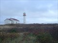
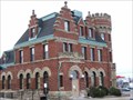
 view gallery view gallery SE7.7 km SE7.7 km
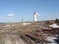
|   Point Aconi Light house Point Aconi Light house
in Coastal Lighthouses Point Aconi Light house, second Light on this landmark posted by:  stagunner stagunner location: Nova Scotia, Canada date approved: 11/17/2007 last visited: 05/11/2010 |
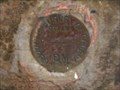 view gallery view gallery S12.4 km S12.4 km
|  56N221M 56N221M
in Canadian Benchmarks 56N221M BIG BRAS D'OR
CONCRETE BRIDGE OVER FIFES BROOK, AT VICTORIA-CAPE BRETON COUNTY BOUNDARY, 2.5 KM SOUTHEAST OF ST-JOHNS UNITED CHURCH, TABLET IN WEST FACE OF SOUTH CONCRETE ABUTMENT, 61 CM FROM SOUTHWEST CORNER, 91 CM BELOW TOP. posted by: PGILL location: Nova Scotia, Canada date approved: 01/22/2007 last visited: never |
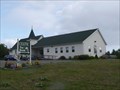
 view gallery view gallery W12.7 km W12.7 km
|  North Shore & District Volunteer Fire Dept. North Shore & District Volunteer Fire Dept.
in Firehouses This rural fire department is on the scenic Cabot Trail about 10 km north of the Englishtown Ferry. posted by:  PeterNoG PeterNoG location: Nova Scotia, Canada date approved: 05/05/2010 last visited: 08/01/2014 |
 view gallery view galleryW13.5 km |  Celtic Tea Room - Nova Scotia, Canada Celtic Tea Room - Nova Scotia, Canada
in Tearooms and Teahouses This Tea Room is located inside the St Anns Bay United Church on the Cabot Trail about 7km north of the Englishtown Ferry. posted by: PeterNoG location: Nova Scotia, Canada date approved: 05/03/2010 last visited: 04/30/2016 |
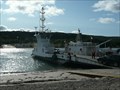 view gallery view gallery SW16.9 km SW16.9 km
|  Englishtown Ferry - Nova Scotia Englishtown Ferry - Nova Scotia
in Ferries and Ferry Landings This ferry on Hwy 312 takes you across St Anns Bay. The trip is only about 125 meters (400 feet). posted by: PeterNoG location: Nova Scotia, Canada date approved: 05/06/2010 last visited: 06/30/2023 |
 view gallery view gallerySW17.1 km |  CNHS - Sainte Anne ~ Englishtown NS CNHS - Sainte Anne ~ Englishtown NS
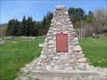
in Canadian National Historic Sites This is historic site of an early Jesuit mission that was selected in 1713 to be a naval base and one of the principal places in Isle Royale.
The cairn located just east of the Englishtown Ferry. posted by: PeterNoG location: Nova Scotia, Canada date approved: 05/03/2010 last visited: 06/06/2014 |
 view gallery view gallerySW17.1 km |  Fort Sainte-Anne - Englishtown, Nova Scotia Fort Sainte-Anne - Englishtown, Nova Scotia
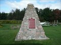
in Cairns This cairn is located in Englishtown, Nova Scotia. This area was previously the site of former French military installations. Fort Sainte-Anne, built by Captain Charles Daniel in 1639, and Fort Dauphin by Jean Baptiste Hertel de Rouville in 1713. posted by: Weathervane location: Nova Scotia, Canada date approved: 05/09/2020 last visited: never |
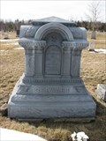 view gallery view gallerySE18.3 km |  ZINC – STEWART, Sydney Mines, Nova Scotia ZINC – STEWART, Sydney Mines, Nova Scotia
in Zinc Headstones A zinc headstone in Brookside Cemetery, Sydney Mines, Nova Scotia. This one is dedicated to Angus STEWART. posted by: Falach-fead location: Nova Scotia, Canada date approved: 04/07/2012 last visited: never |
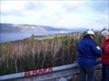
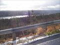 view gallery view gallerySW18.7 km |  Kelly's Mountain Look Off, Cape Breton Island Nova Scotia, Canada Kelly's Mountain Look Off, Cape Breton Island Nova Scotia, Canada
in Scenic Roadside Look-Outs Kelly's Mountain Look Off on Kelly's Mountain on the Trans Canada Highway Cape Breton Canada posted by: stagunner location: Nova Scotia, Canada date approved: 11/24/2007 last visited: 09/07/2018 |
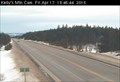 view gallery view gallerySW19.2 km |  Kelly's Mountain Highway Webcam - Kelly's Mountain, NS Kelly's Mountain Highway Webcam - Kelly's Mountain, NS
in Web Cameras The province of Nova Scotia operates a network of highway webcams throughout the province to aid motorists in assessing road conditions before heading out for a long weekend of fishing. posted by: T0SHEA location: Nova Scotia, Canada date approved: 04/19/2015 last visited: 07/09/2016 |
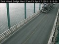 view gallery view gallerySW19.3 km | Seal Island West Highway Webcam - New Harris, NS in Web Cameras The province of Nova Scotia operates a network of highway webcams throughout the province to aid motorists in assessing road conditions before heading out for a long weekend of fishing. posted by: T0SHEA location: Nova Scotia, Canada date approved: 04/19/2015 last visited: 09/07/2018 |
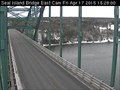 view gallery view gallerySW19.3 km | Seal Island East Highway Webcam - New Harris, NS in Web Cameras The province of Nova Scotia operates a network of highway webcams throughout the province to aid motorists in assessing road conditions before heading out for a long weekend of fishing. posted by: T0SHEA location: Nova Scotia, Canada date approved: 07/06/2015 last visited: 09/07/2018 |
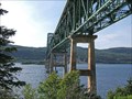 view gallery view gallerySW19.3 km |  SEAL ISLAND BRIDGE, CAPE BRETON ISLAND, NS SEAL ISLAND BRIDGE, CAPE BRETON ISLAND, NS
in Truss Bridges The Seal Island Bridge is an arch truss bridge crossing the Great Bras d'Or channel of Bras d'Or Lake in Victoria County on Nova Scotia's Cape Breton Island. posted by: PGILL location: Nova Scotia, Canada date approved: 01/23/2007 last visited: 06/30/2023 |
 view gallery view gallerySE19.3 km | 18N1879 in Canadian Benchmarks OLD (BURNED) POST OFFICE AT SW CORNER OF INTERSECTION OF HIGHWAY NO. 125 AND HIGHWAY NO. 305, 350 M NW OF POST OFFICE, BOLT IN SECOND COURSE OF STONE ABOVE SIDEWALK, AT LEFT SIDE OF CORNER ENTRANCE, 1.52 M FROM NICHE CONTAINING LETTER DROP posted by: PGILL location: Nova Scotia, Canada date approved: 01/23/2007 last visited: 08/31/2017 |
 view gallery view gallerySW19.5 km | St Anns Look Off Cape Breton Nova Scotia in Scenic Roadside Look-Outs St Anns Look Off Cape Breton Nova Scotia posted by: stagunner location: Nova Scotia, Canada date approved: 11/25/2007 last visited: 06/30/2023 |
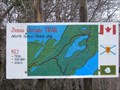 view gallery view galleryS19.8 km |  Branch Road Trail, North Sydney, NS Branch Road Trail, North Sydney, NS
in Rails to Trails The history of the Branch Road "rails to trails" is tied to the Sydney Steel Plant, the many coal mines of Cape Breton Island, and the rail car/passenger ferry link at North Sydney to Newfoundland and St Pierre during World War II. posted by: PGILL location: Nova Scotia, Canada date approved: 05/27/2008 last visited: never |
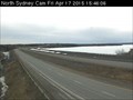 view gallery view galleryS20.9 km | North Sydney Highway Webcam - North Sydney, NS in Web Cameras The province of Nova Scotia operates a network of highway webcams throughout the province to aid motorists in assessing road conditions before heading out for a long weekend of fishing. posted by: T0SHEA location: Nova Scotia, Canada date approved: 04/19/2015 last visited: never |
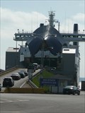 view gallery view gallerySE21.1 km | North Sydney Ferry Terminal - Nova Scotia in Ferries and Ferry Landings Marine Atlantic operates ferry service from their terminal in North Sydney, Nova Scotia to Newfoundland on two routes; to Port Aux Basques and to Argentia. posted by: PeterNoG location: Nova Scotia, Canada date approved: 12/02/2010 last visited: 06/30/2023 |
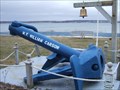 view gallery view gallerySE21.1 km |  MV William Carson - Anchor, Nova Scotia, Canada MV William Carson - Anchor, Nova Scotia, Canada
in Anchors MONUMENT TO THE MV WILLIAM CARSON 1958 - 1975.
The MV William Carson was the first drive-on passenger ice breaking ferry to serve the Cabot Strait between North Sydney NS and Port Aux Basques NFLD. posted by: PGILL location: Nova Scotia, Canada date approved: 01/25/2007 last visited: 08/07/2015 |
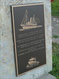 view gallery view gallerySE21.2 km |  Ferry Service NL to NS - 100 Years - North Sydney NS Ferry Service NL to NS - 100 Years - North Sydney NS
in Commercial Commemorations A 1998 plaque to commemorate 100 years of ferry service between Port Aux Basques, Newfoundland and North Sydney, Nova Scotia. posted by: PeterNoG location: Nova Scotia, Canada date approved: 07/09/2010 last visited: 08/31/2017 |
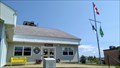
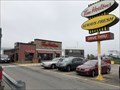 view gallery view gallerySE21.2 km |  Tim Hortons - North Sydney, NS Tim Hortons - North Sydney, NS
in Tim Horton's Restaurants Tim Hortons serving North Sydney posted by: stinger503 location: Nova Scotia, Canada date approved: 02/29/2024 last visited: never |
 view gallery view gallerySE21.2 km |  Subway - North Sydney NS Subway - North Sydney NS
in Subway Restaurants Subway is a short walk from the ferry terminal. posted by: elyob location: Nova Scotia, Canada date approved: 08/11/2021 last visited: never |
 view gallery view gallerySE21.4 km |  Wilfred Oram Centennial Library, North Sydney, Nova Scotia Wilfred Oram Centennial Library, North Sydney, Nova Scotia
in Libraries You may see the museum before you see the library. posted by: elyob location: Nova Scotia, Canada date approved: 07/30/2021 last visited: never |
 view gallery view galleryS22.2 km |  Georges River Limestone Quarry, Georges River, Nova Scotia, Canada. Georges River Limestone Quarry, Georges River, Nova Scotia, Canada.
in Active Quarries Georges River Limestone Quarry, Georges River, Nova Scotia, Canada.
Latitude : N46° 10.990
Longitude : W60° 22.177 posted by: PGILL location: Nova Scotia, Canada date approved: 05/26/2008 last visited: 05/11/2010 |
 view gallery view gallerySE22.5 km | Low Point Lighthouse in Coastal Lighthouses Low Point Lighthouse located on the edge of Sydney Harbour close to the town of New Waterford posted by: stagunner location: Nova Scotia, Canada date approved: 11/12/2007 last visited: 06/26/2023 |
|