 view gallery view gallery NE0.8 km NE0.8 km
|   Mur peint - Saint-Denis d'Oléron, Charente-Maritime Mur peint - Saint-Denis d'Oléron, Charente-Maritime
in Murals Un mur peint le long d'une jetée
A wall painted along a jetty posted by:  Caty1723 Caty1723 location: Nouvelle-Aquitaine, France date approved: 01/14/2018 last visited: 02/23/2023 |
 view gallery view gallery NW2.4 km NW2.4 km
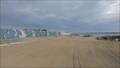
|  Blockhaus de Chassiron - Ile d'Oléron, France Blockhaus de Chassiron - Ile d'Oléron, France
in Luftwaffe Radar Ruins Un parmi d'autres blockhaus de la pointe de l'ile d'Oléron.
One among other bunker tip of the island of Oleron. posted by: Tooms et Jess location: Nouvelle-Aquitaine, France date approved: 11/14/2013 last visited: 02/23/2023 |
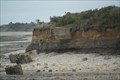
![Image for [Arm] La Brée-les-Bains - Canon](https://img.geocaching.com/waymarking/small/9164fee6-4263-4099-9ffb-36ef45b570cc.jpg) view gallery view gallery SE2.6 km SE2.6 km
|  [Arm] La Brée-les-Bains - Canon [Arm] La Brée-les-Bains - Canon
in Static Artillery Displays This cannon is displayed in front of the sea.
---
Canon exposé en bord de mer. posted by: BmarcW location: Nouvelle-Aquitaine, France date approved: 05/20/2015 last visited: 07/21/2018 |
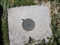
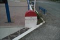 view gallery view galleryNW2.7 km |  Borne de Chassron à Oléron Borne de Chassron à Oléron
in French Benchmarks Borne KM annoncant les distances de grandes villes. posted by: Tooms et Jess location: Nouvelle-Aquitaine, France date approved: 11/13/2013 last visited: 02/23/2023 |
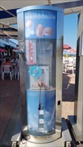 view gallery view galleryNW2.7 km |  Mémodaille Chassiron, Charente Maritime, France Mémodaille Chassiron, Charente Maritime, France
in Penny Smashers Smasher qui transforme une pièce de 5cts d'Euro et pièce estampillée "Phare de Chassiron" ou "Fort Boyard" posted by: Nathalain location: Nouvelle-Aquitaine, France date approved: 08/23/2018 last visited: 02/23/2023 |
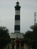
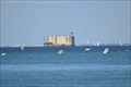
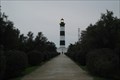 view gallery view galleryNW2.9 km |  Phare de Chassiron - Ile d'Oléron, France Phare de Chassiron - Ile d'Oléron, France
in Coastal Lighthouses Chassiron lighthouse, perched on a rocky cliff, is located at the northern end of the island of Oléron, near the town of Saint-Denis d'Oléron. The lighthouse allows sailors to return to the waters of the sluice of Antioch. posted by: Tooms et Jess location: Nouvelle-Aquitaine, France date approved: 11/13/2013 last visited: 02/23/2023 |
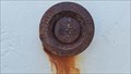
 view gallery view galleryNW2.9 km | Phare de Chassiron à Oléron in French Benchmarks réseau géodésique de détail posted by: Tooms et Jess location: Nouvelle-Aquitaine, France date approved: 11/13/2013 last visited: 02/23/2023 |
 view gallery view galleryNW2.9 km | Chassiron : Le phare , Charente Maritime in French Benchmarks A gauche de l'entrée du phare. posted by: Nathalain location: Nouvelle-Aquitaine, France date approved: 08/23/2018 last visited: 02/23/2023 |
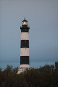
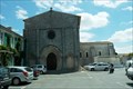
 view gallery view galleryNW2.9 km |  Le Phare de Chassiron - Saint-Denis d'Oléron, France Le Phare de Chassiron - Saint-Denis d'Oléron, France
in Monuments Historiques Français [FR] Le phare de Chassiron se situe sur la pointe Nord de l'Ile d'Oléron, connue sous le nom de "bout du monde".
[EN] The lighthouse of Chassiron is located on the northern tip of the island of Oléron, known as the "end of the world". posted by: pmaupin location: Nouvelle-Aquitaine, France date approved: 06/15/2017 last visited: 02/23/2023 |
 view gallery view galleryNW2.9 km |  Le Phare de Chassiron - Saint-Denis d'Oléron, France Le Phare de Chassiron - Saint-Denis d'Oléron, France
in Wikipedia Entries [EN] The lighthouse of Chassiron is located on the northern tip of the island of Oléron, known as the "end of the world".
[FR] Le phare de Chassiron se situe sur la pointe Nord de l'Ile d'Oléron, connue sous le nom de "bout du monde". posted by: pmaupin location: Nouvelle-Aquitaine, France date approved: 06/14/2017 last visited: 02/23/2023 |
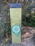
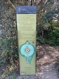
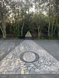 view gallery view galleryNW3.1 km |  Les jardins du Phare de Chassiron - ILe d'Oléron - France Les jardins du Phare de Chassiron - ILe d'Oléron - France
in Compass Roses Découvrez ce jardin contemporain conçu sous la forme d'une rose des vents, au pied du phare de Chassiron. Créé en 2007, il est labellisé "Jardin Remarquable". Entrée libre. posted by: Alfouine location: Nouvelle-Aquitaine, France date approved: 05/31/2023 last visited: never |
 view gallery view galleryNW3.1 km |  Les jardins du Phare de Chassiron - ILe d'Oléron - France Les jardins du Phare de Chassiron - ILe d'Oléron - France
in Demonstration Gardens Découvrez ce jardin contemporain conçu sous la forme d'une rose des vents, au pied du phare de Chassiron. Créé en 2007, il est labellisé "Jardin Remarquable". Entrée libre. posted by: Alfouine location: Nouvelle-Aquitaine, France date approved: 05/31/2023 last visited: never |
 view gallery view galleryNW3.1 km |  Les jardins du Phare de Chassiron - ILe d'Oléron - France Les jardins du Phare de Chassiron - ILe d'Oléron - France
in Official Local Tourism Attractions Découvrez ce jardin contemporain conçu sous la forme d'une rose des vents, au pied du phare de Chassiron. Créé en 2007, il est labellisé "Jardin Remarquable". Entrée libre. posted by: Alfouine location: Nouvelle-Aquitaine, France date approved: 05/10/2023 last visited: never |
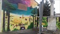
 view gallery view gallerySE3.2 km | Mur peint - La Brée-les-bains - Ile d'Oléron, Charente-Maritime in Murals Un magnifique mur peint face à la mer
A beautiful painted wall facing the sea posted by: Caty1723 location: Nouvelle-Aquitaine, France date approved: 01/14/2018 last visited: 01/14/2018 |
 view gallery view gallerySE7.1 km | SAINT-GEORGES-D'OLERON VII in French Benchmarks repère géodésique de détail posted by: Tooms et Jess location: Nouvelle-Aquitaine, France date approved: 07/15/2014 last visited: 02/23/2023 |
 view gallery view gallerySE7.1 km | Eglise de st Georges d'Oléron in French Benchmarks repère de nivellement cylindrique posted by: Tooms et Jess location: Nouvelle-Aquitaine, France date approved: 07/15/2014 last visited: 02/23/2023 |
 view gallery view gallerySE10 km |  Plage des Saumonards. Oleron . France Plage des Saumonards. Oleron . France
in Nude Beaches Plage naturiste des Saumonards posted by: lulu_et_compagnie location: Nouvelle-Aquitaine, France date approved: 09/17/2015 last visited: 02/23/2023 |
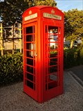 view gallery view gallerySE11.3 km |  Cabine Téléphonique Rouge - Saint-Pierre-d'Oléron, France Cabine Téléphonique Rouge - Saint-Pierre-d'Oléron, France
in Red Telephone Boxes [FR] Une cabine téléphonique rouge dans la première ville de l'île d'Oléron. [EN] A red telephone box in the largest city on the Oléron island. posted by: RakeInTheCache location: Nouvelle-Aquitaine, France date approved: 10/12/2014 last visited: 04/02/2018 |
 view gallery view gallerySE11.3 km | Mur peint - Saint-Pierre d'Oléron, Charente-Maritime in Murals Un magnifique mur peint
A wonderfull mural posted by: Caty1723 location: Nouvelle-Aquitaine, France date approved: 12/23/2017 last visited: 02/23/2023 |
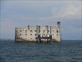
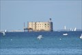
 view gallery view gallery E13.2 km E13.2 km
| Fort Boyard - Ile-d'Aix, France in Wikipedia Entries [EN] Fort Boyard is a fortification located on a high bottom formed of a sandbar at the origin, called the "Boyard's lanyard" which is discovered at low tide.
[FR]Le fort Boyard est une fortification située sur un haut fond formé d'un banc de sable à l'origine, appelé la « longe de Boyard » qui se découvre à marée basse. posted by: pmaupin location: Nouvelle-Aquitaine, France date approved: 06/23/2018 last visited: 02/23/2023 |
 view gallery view galleryE13.2 km | Fort Boyard - Ile-d'Aix, France in Monuments Historiques Français [FR] Le fort Boyard est une fortification située sur un haut fond formé d'un banc de sable à l'origine, appelé la « longe de Boyard » qui se découvre à marée basse.
[EN]Fort Boyard is a fortification located on a high bottom formed of a sandbar at the origin, called the "Boyard's lanyard" which is discovered at low tide. posted by: pmaupin location: Nouvelle-Aquitaine, France date approved: 06/23/2018 last visited: 02/23/2023 |
 view gallery view galleryE13.2 km |  Fort Boyard - Ile-d'Aix, Nouvelle Aquitaine, France Fort Boyard - Ile-d'Aix, Nouvelle Aquitaine, France
in Historic Forts [EN]Fort Boyard is a fortification located on a high bottom.
[FR] Le fort Boyard est une fortification située sur un haut fond. posted by: sara et gege location: Nouvelle-Aquitaine, France date approved: 03/13/2019 last visited: 02/23/2023 |
 view gallery view galleryE13.2 km |  Fort Boyard - Ile-d'Aix, France Fort Boyard - Ile-d'Aix, France
in Satellite Imagery Oddities [EN] Fort Boyard is a fortification located on a high bottom formed of a sandbar at the origin, called the "Boyard's lanyard" which is discovered at low tide. [FR]Le fort Boyard est une fortification située sur un haut fond formé d'un banc de sable à l'origine, appelé la « longe de Boyard » qui se découvre à marée basse. posted by: pmaupin location: Nouvelle-Aquitaine, France date approved: 07/26/2019 last visited: 02/23/2023 |
 view gallery view galleryE13.2 km | Repere geodesique SAINT-GEORGES-D'OLERON VIII in French Benchmarks Fort Boyard comme à la Television. posted by: sara et gege location: Nouvelle-Aquitaine, France date approved: 10/24/2015 last visited: 02/23/2023 |
 view gallery view gallery N13.2 km N13.2 km
| Repere Crue Xynthia - Sainte Marie de Re, France in French Benchmarks un repère de crue de la tempête Xynthia en 2010 . posted by: sara et gege location: Nouvelle-Aquitaine, France date approved: 05/04/2016 last visited: 05/04/2016 |
|